
THE Cadillac on Cadillac Hill
Posted: July 7, 2024 Filed under: Uncategorized | Tags: cadillac, Cadillac Hill, steve-morris 3 CommentsAnyone who is minimally aware of the Rubicon Trail, has heard of Cadillac Hill. But how many know the story of how it got its name? And how the Cadillac got there? I’m honestly not sure if I do.

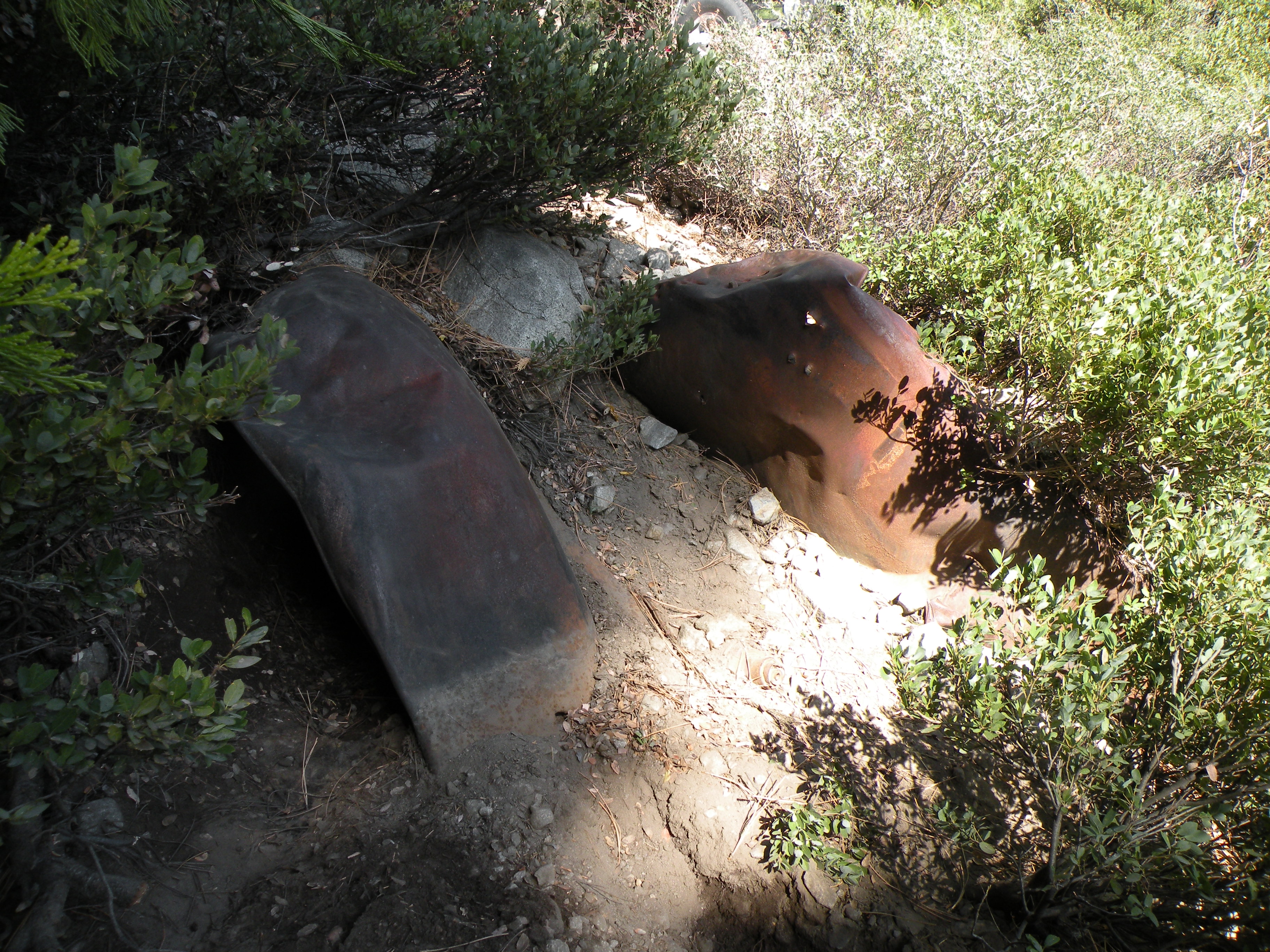
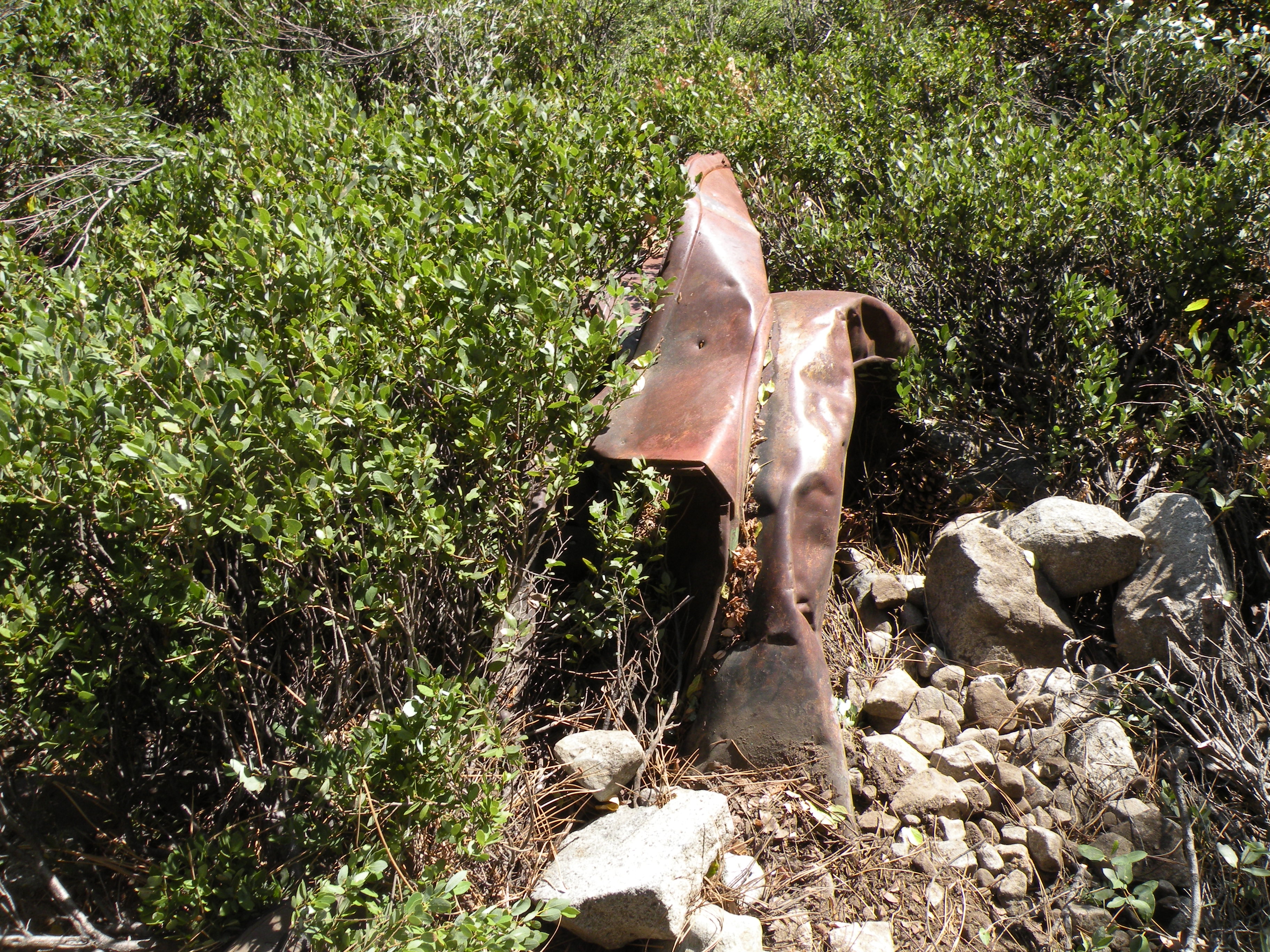
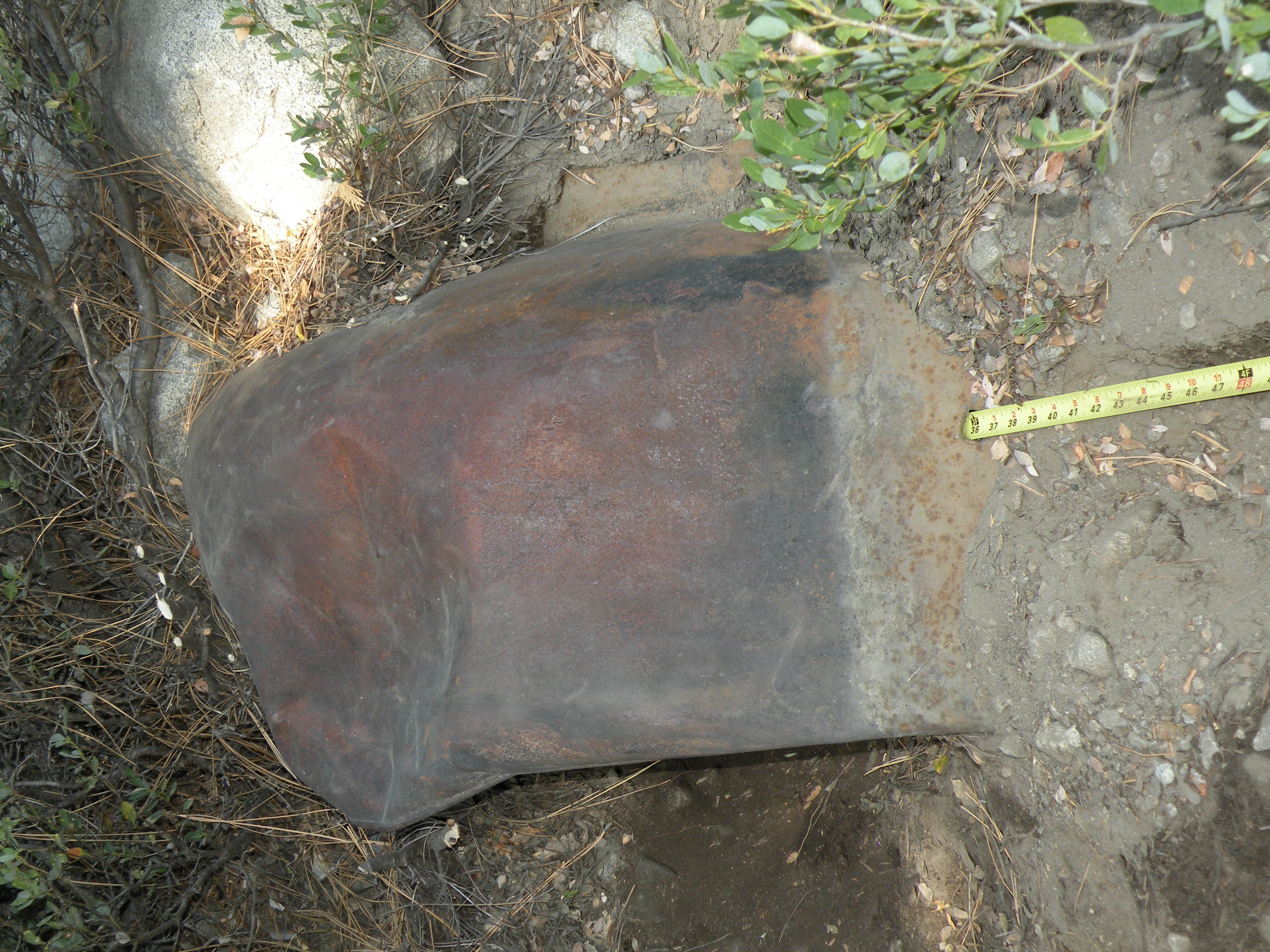
The story I heard was that two sons borrowed dad’s Cadillac to go down to Rubicon Springs. On the way out it broke, got stuck and was left on the side of the trail. Over the years, people took parts off it for souvenirs. All that is left is the frame, front axle and some fenders. Back in those days, the trail was a graded dirt road. It’s not like trying to take an Escalade to the Springs today.
But over the years, rumors circulated that it might not be a Cadillac but a LaSalle. Personally, I thought LaSalle was just a sub-model of a Cadillac, so I never cared about the story. Either way, it would always be Cadillac Hill to me.
One day (November of 2009) I got a call from Steve Morris. Yes, the Steve Morris for whom “Morris Rock” has been named. That obstacle is also known as the ‘The Steps’. Steve’s Cadillac Hill history is that he would leave the Jeepers Jamboree very early Sunday morning and position his red CJ-5 at the top of ‘The Steps’ in order to winch those who could not make it on their own. His famous advice was to start in second gear, as first was too low. He did this for decades. Yes, decades.
Steve was also known for tall, skinny tires, that were usually over inflated and his lack of delicacy while wheeling. But Steve always made it. I don’t think I’ve ever heard of Steve not making it through the trail. There is a story of Steve driving someone out from Rubicon Springs, to the hospital after multiple Black Widow spider bites. He made record time and saved the guys’ life.
So, the phone call. Steve and I knew each other. I considered him a friend. But we didn’t hang out. So, I was surprised by the call. He said he needed to drive in on the Rubicon, but not too far, and those around him had asked that he not wheel alone, so he was calling to see if I’d go with him.
Okay, this is like golfing Pebble Beach with Arnold Palmer, driving around the Indianapolis Speedway with AJ Foyt, throwing a football with Joe Montana or surfing Malibu with Robert August.

Of course, I said yes and agreed to meet him at his cabin in a few days. I didn’t bother asking why.
When I arrived at his cabin, he was ready to go with his lunch, a tool bag and a thermos of coffee. He explained that his son Rick was writing a book about the history of the Rubicon Springs property. The story of the Cadillac came up as did the rumors of it being a LaSalle. So, Steve wanted to go out to the wreck and prove it once and for all, one way or the other. I reminded Steve that we probably were not going to be able to open the glove box and check the registration for the name of the manufacturer. He laughed and said that he had a method worked out.
Then he shocked the heck out of me. He asked that since we were not going in too far, would I mind just taking my Jeep and giving him a ride to the wreck. He reasoned that we didn’t need two vehicles.
Without missing a beat, I said sure, no problem, let’s go. Inside my stomach started to turn. Following Steve along the Rubicon Trail was cool enough, I had followed him out of the Springs and up Cadillac Hill once before and he showed me the original route not the now closed trench past Mog Camp. What an honor for just being asked to join him. But to actually give him a ride, in my Jeep, on the Rubicon Trail, down “Morri Rock”!?!?!?! I was petrified of messing up. But off we went.

For the most part, the trip in was uneventful. Of course, the trail from the staging area towards Cadillac Hill is pretty basic. Where it approaches ‘Hummer Bend’, before it leaves the trees and gets out on some granite slabs at what I call ‘The Step’ and others call ‘Birthday Cake’, there’s a hard left turn around a very large, rounded boulder. The shorter the wheelbase, the further left, on to the boulder you can go. I’m in a CJ-7 on 35s. I’ve done this obstacle a hundred times. This time, I started too far left and was stopped when the skid plate hit the boulder. Steve said, “I thought you were too far left”. Reverse, move right, try again, off we went.
As we continued down the trail, Steve explained his plan. He and Rick had done some research and found that there was a difference of six inches in the wheelbase between a Cadillac and a LaSalle. I can’t remember which was which, but Steve had a plan. All we had to do was measure the wheelbase.
When we got down to the area where the frame and fenders are off the side of the trail, I did an Austin Powers 12-point U-turn and parked off to the side of the trail, out of the way of traffic.
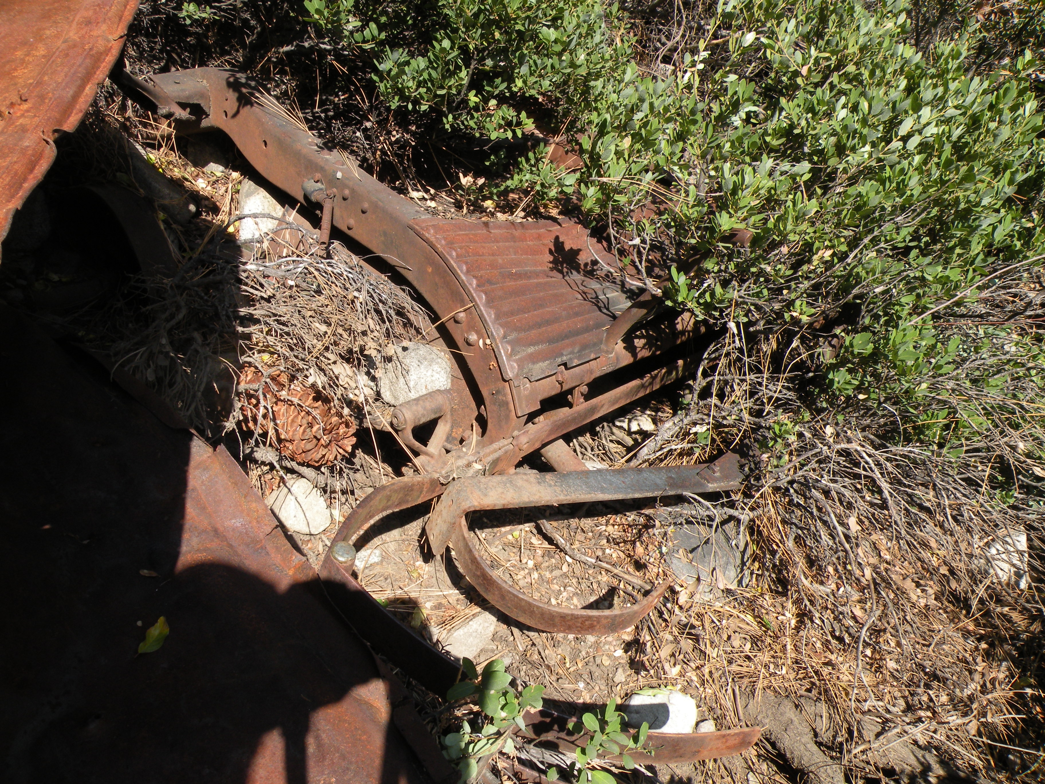
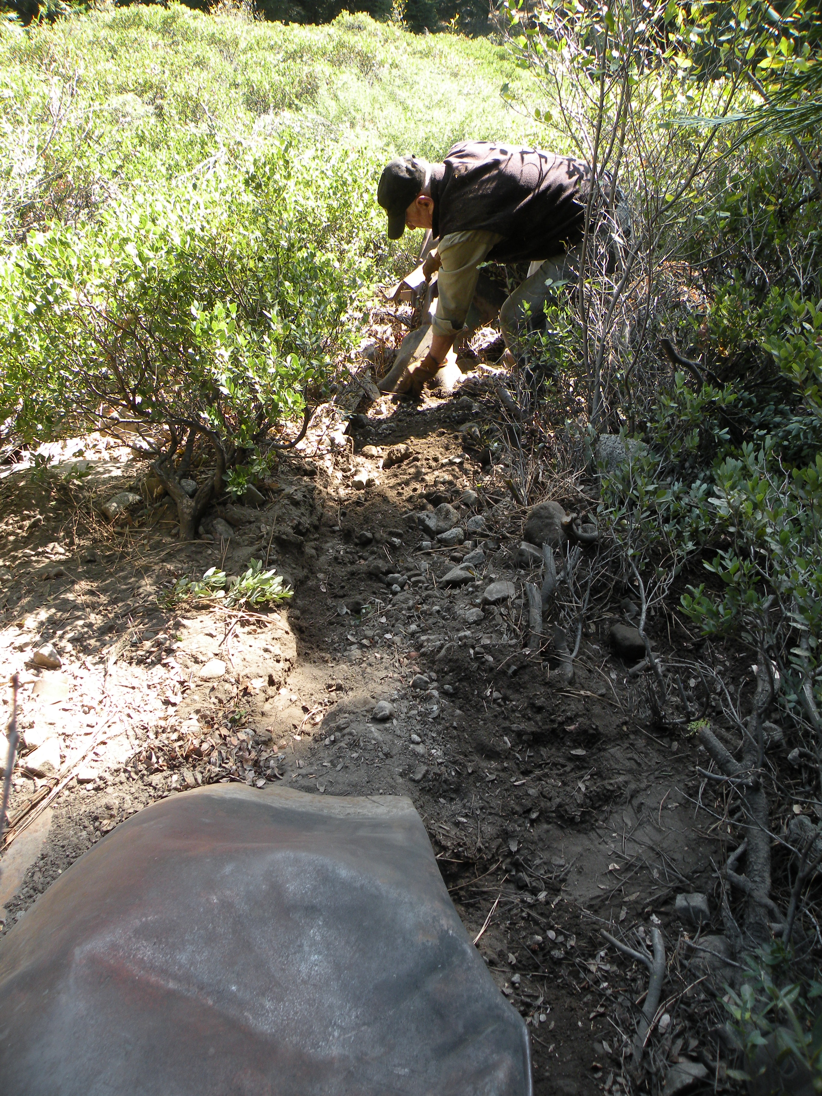
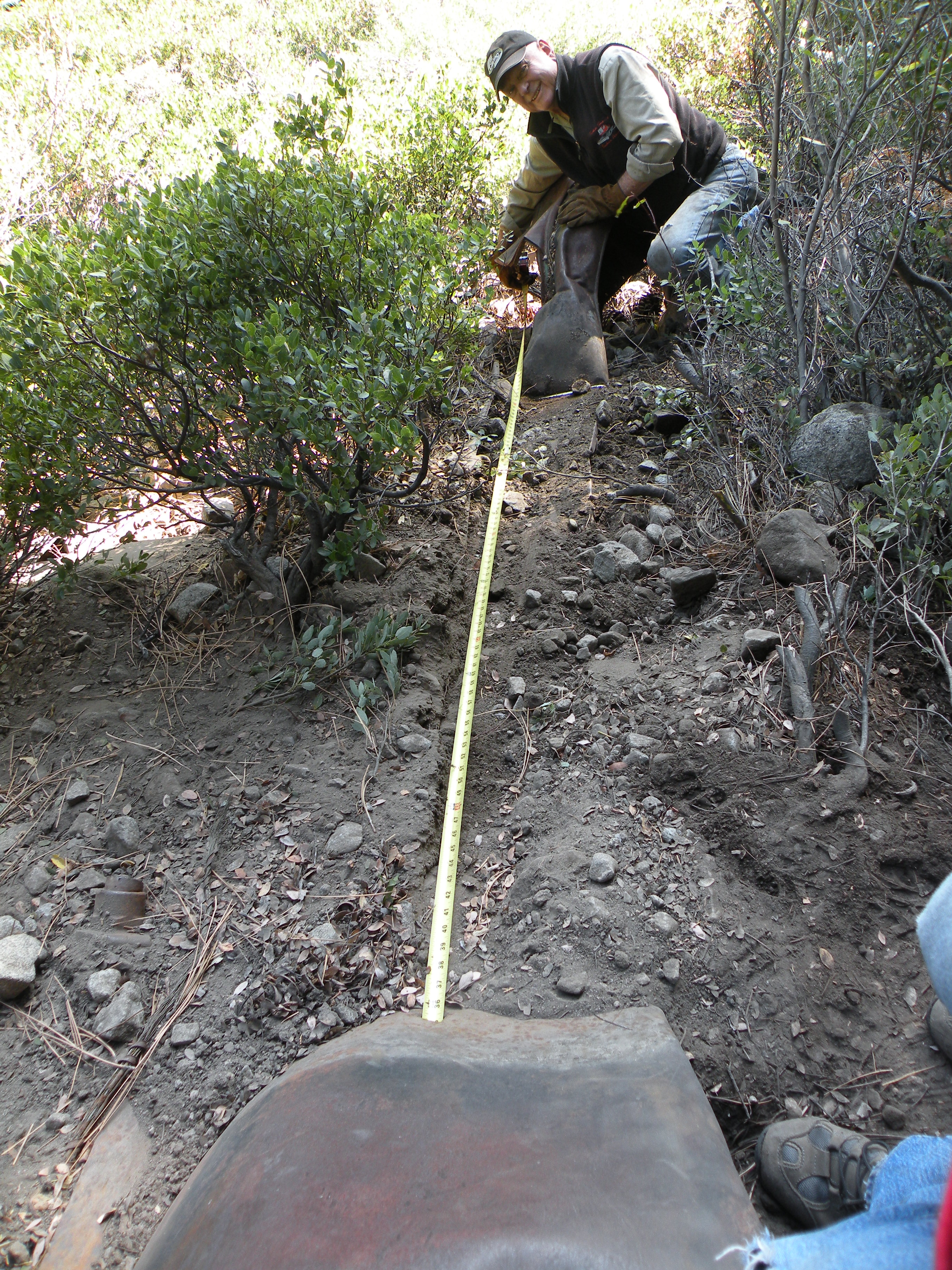
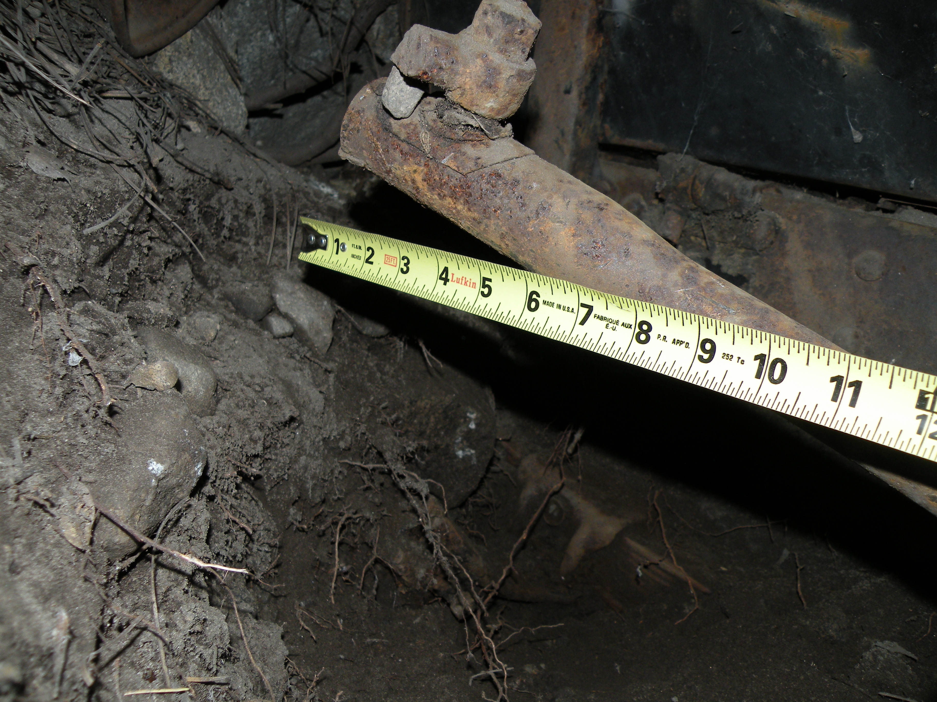
I grabbed a shovel, Steve grabbed a tape measure and over the side of the trail we went. The frame had settled down into the dirt more than I had expected. If I remember correctly, the front axle was still in place, but the rear axle was gone. We wondered about how we were going to get an accurate measurement without the rear axle in place. I suggested that there might be an axle alignment pin like there is on modern leaf springs. The leaf spring was there but buried. I started digging.
Without the rear axle, Steve was concerned about getting that accurate measurement with the tape measure outside the front fender at the hub and the tape measure much more inside near the frame in the rear. Steve said he knew what to do and told me to keep digging. Steve scrambled back up to my Jeep and I kept digging.
Without warning, I hear a very loud metal on metal on metal banging and banging and banging. I turned (actually jumped) to see what was going on. Steve had a pointed chisel in his left hand, a rather large hammer in his right hand and he was pounding a hole into, rather through, the left front fender so he could slide the tape measure through the hole to keep it parallel with the frame in order to get an accurate wheelbase measurement.

Spoiler alert, it is a Cadillac!
We packed up our things and headed out. On the trip out there were no mishaps regarding my driving. After passing ‘Potato Patch’ and ‘Bottom Dollar Hole’, Steve tipped his hat to me and said good job, referring to my driving. What a complement.
I think we drove all the way to out Steve’s cabin before stopping and I aired up there. While doing a quick walk around the rig before hitting the road, I noticed that the right rear leaf spring shackle had flipped. It was flat against the frame with the spring over arched and not flexing.
After I thought about it, it probably happened when I did the Austin Powers U-turn at the Cadillac. That means I drove all that way out and didn’t notice that one of my springs was not flexing. I got out the Highlift jack and Steve grabbed me a long pry bar from his garage. With most of the weight off that spring, I very cautiously used the prybar to flip the shackle back to its normal position. Yes, I was staying well off to the side in case things went sideways.

The above photo is the money shot. Steve Morris standing over THE Cadillac on Cadillac Hill and my CJ-7 in the background! What a day.
Jeep fixed, I was back on the road.
It was a day I will never forget.
Thanks for the phone call Steve. R.I.P!
.
Doug Barr (aka Rubicon Ronin)
ENF Fire Restriction Start 7-3-24
Posted: July 2, 2024 Filed under: Uncategorized Leave a commentAs documented, camp fire restrictions on the Eldorado national Forest start tomorrow, July 3rd.
FYI, the Lake Tahoe Basin Management Unit always have fire restrictions in place. They only allow fires in steal fire pits in Forest Service campgrounds.
Be fire safe. Don’t be that guy.
.
Rubicon Ronin
TNF Fire Restrictions are in place
Posted: July 1, 2024 Filed under: Uncategorized Leave a commentWe all knew it was coming. I’m surprised it took so long. Isn’t it usually in June?
Be safe out there. Don’t be that guy!
.
Rubicon Ronin
LTBMU Gates Unlocked
Posted: June 19, 2024 Filed under: Uncategorized Leave a commentI have heard that the gates up Blackwood Canyon have been unlocked by the Lake Tahoe Basin Management Unit. This should be the upper and lower gates on the paved road, 03 and the lower gate on the Middle Fork Trail 15N38.
Again, I heard the Middle Fork is passable with trees across the trail but you can drive over them.
I do not have a trail report for the Barker Meadow OHV Trails (upper and lower, 16E76 & 16E79).
Please be prepared to deal with trees across the trail. “Turn Around, Don’t Go Around” is the official slogan of this website and a good rule of thumb for the trails.
.
Rubicon Ronin
Clearing Trees, Finding Snow
Posted: June 16, 2024 Filed under: Uncategorized | Tags: closed, gate, gates, snow, trees Leave a commentToday was supposed to be my annual spring tree clearing trip for the side trails along the Rubicon Trail.
When I got to the bottom of the Middle Fork Trail, I found the gate still locked. It was supposed to be unlocked on June 1st. The gate on the paved road to the top of Barker Pass was also locked. It was supposed to be unlocked on June 15th.
I’ve already sent an email to the Forest Service complaining.
So, not able to clear 15N38, 16E79 and 16E76, I headed for the Rubicon. I went up the Sourdough Trail and cleared eight trees from the trail. I was the first 4-wheeled vehicle to the top this year. But it looked like a pair of motorcycles had already made the journey.
Work smarter, not harder. Fewer chainsaw cuts and more winching.

My reward for clearing that first tree was three down in the same area, right around the corner.

With time on my hands, I tried my luck up the Ellis Lake/Peak Trail. It is quite narrow these days. I was able to get to the area with the open meadow.
This one/group was on the Ellis Peak/Lake Trail. I left it as it was quite large and the go around was not crazy off trail.

Further up the Ellis Trail the snow became more than I was willing to take on. I had already busted through a few drifts and winched over one.
The trail is under all that snow as it goes into the trees! Think side hill on slippery snow, sliding into the trees. No thanks.

I also popped up the Buck Lake Trail but only to the lake, not above. Maybe next week I’n try again, but the FS needs to open a few gates.
.
Rubicon Ronin

