
Area Trails
Here is list of OHV trails in the area of the Tahoe side of the Rubicon Trail. I’ve added a trail rating for each, going by memory as a guide. Every winter these trails can change. Explore with caution and remember “Turn Around, Don’t Go Around”, if you get to a section of trail you can’t negotiate.
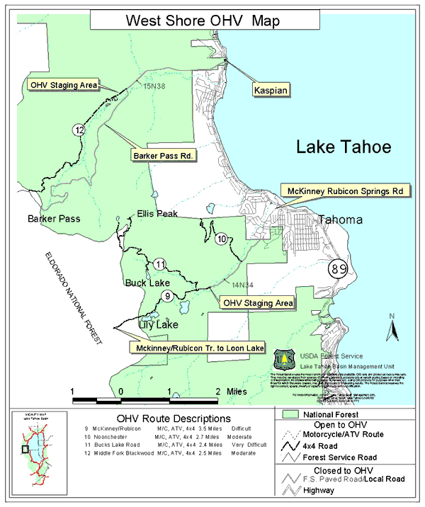
Lake Tahoe Basin Management Unit
Tahoe National Forest
- Ellis Lake/Peak Trail
- Ellis Peak Motorcycle Trail
- Forest Road 003-004
- Barker Meadow OHV Route
- Long Lake Trail (TKS-11)
Eldorado National Forest

The “Overland Journal” has a great article about how to rate a trail. I blogged about it a few years go and figured I should outline the scale here.
Full blog article with detailed descriptions: https://wordpress.com/post/theotherrubicon.com/4826
The scale is 1 through 5, with half numbers.
1 = Improved/Graded Dirt Road
1.5 = Graded Dirt Road
2 = Formed Track
2.5 = Rugged Track
3 = Formed Trail
3.5 = Rugged Trail
4 = Challenging Trail
4.5 = Extreme Trail
5 = No Trail*
*Okay, we preach and follow the doctrine of “Stay On the Trail”. This description applies to legal cross country travel or a trail like the “Hammers” where there is a documented trail but nothing resembling a road or trail.
Moving forward, I will rate every trail in this area on their specific page and list trails under these ratings so you can find what level you’re looking for in the way of a challenge. Please let me know if you disagree with my ratings of these trails. My goal is to gauge these for new users. I get on every one of these every year but it takes all summer. If the winter has changed these, let me know.
Understand that the trail will be rated on its hardest section. I’ll try and detail each trail so you know if that 4 rating is for the entire length or just two specific spots.
Listing of sections of trails and the rating (X.X) of each:
Rubicon: 89 to staging (1.0)
Rubicon: staging to 03-04 (2.5)
Rubicon: 03-04 to Observation (3.5)
Rubicon: Observation to the Graves (4.0)
Rubicon: Graves to the springs (3.5)
Noonchester Mine Road (1.5)
Buck Lake (to the lake) (3.0)
Buck Lake (above the lake) (3.5)
Richardson Lake (1.5)
Ellis Lake (03-04012-05) (2.5)
Ellis Peak (14N40B) (2.5)
Ellis Motorcycle (16E16) single track, steep on north west end (3.0), the rest is flat and rolling(2.0)
Ellis Meadow (03-04-12) (2.5)
03-04: Rubicon to Bear Lake (2.5)
03-04: Bear to 03 (2.0)
Barker Meadow – lower (3.5)
Barker Meadow – upper (2.5)
03: 89 to Barker Pass (1.0)
03: Barker Pass west (1.5)
Hell Hole view (03-06-02) (2.5)
Valley View (03-06-04) (2.5)
Middle Fork (2.5)
Great maps with map of residential area, Rubicon and the TNF OHV routes:

The route past Bear Lake going to Blackwood Canyon Road is Forest Road 003-004.
.

