
Reno Jeep Festival: Oct 12-15
Posted: September 19, 2023 Filed under: Maintenance, Travel | Tags: education Leave a commentIt’s been a slow wheeling season for me. But lots going on around the house. I’ve signed up to do a booth at the Reno Jeep Festival’s “Jeep Takeover” of Idlewild Park in Reno. I’ll also be attending the cocktail party and the dinner.
It starts Thursday October 12th at the Reno Jeep Dealership with a cocktail party. Friday the 13th is the dinner at The Whitney in downtown Reno. Saturday the 14th starts with an all you can eat pancake breakfast, followed by the Jeep Takeover of Idlewild Park. There will be vendors along with a “Turtle Crawl” event, Show & Shine and they’re saying a “Beer Garden”. It will be October. On Saturday the 15th, they’re trying to get some runs organized but no details on that yet.
Here’s what the organizers are saying about the event:
Freedom. The Reno Jeep Festival fundraiser supports and celebrates the groups helping to keep our trails open and safe so we can reach, enjoy and reconnect with nature and our innate sense of adventure. All this and a chance to celebrate the Jeep brand we are so passionate about. We are SO excited about this show and the support it creates with the groups protecting freedom for our outdoor and off-road community.
FUNDRAISING
It’s the reason we put this whole thing on. To raise money and protect our trails. Our aim is to keep the trails we love accessible for current and future generations.
It should be a fun event.
.
Doug
Side Trails Update
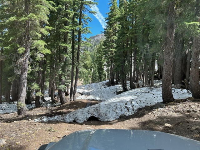
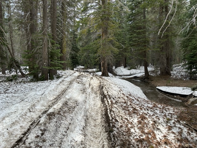
Posted: August 1, 2023 Filed under: Access, Maintenance, Travel | Tags: snow Leave a commentOkay, when at first you don’t succeed, try, try again. So, I tried the same route that I didn’t make do to snow and this time I got through. Now, there was still a few snow drifts. And up the Ellis Lake Trail, there were many!
Still evidence of people driving off trail to get around snow drifts. I threw a few small trees down but a larger effort (and tree) will be needed. This was the Red Cabin Trail (16E79).

Trail on the left, illegal bypass on the right. It’s uglier where the bypass comes back in to the trail.

Still 16E79.

This time of year, really? How hard are mini snow drifts?

One tree was not quite across the trail but pushing people to the side. I got out my new DeWalt mini chainsaw and trimmed all the branches on the underside.

Way off on the Ellis Lake Trail (16E18), there was a HUGE tree trunk across the trail. It is rotten, probably doesn’t weight a whole lot, but I decided I didn’t want to fight it today.

In the same area as the tree trunk, there are some very large snow drifts.
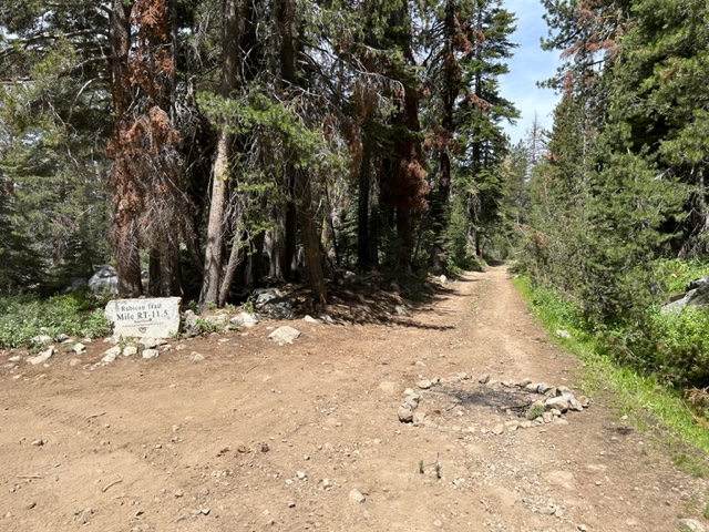
My favorite find of the day, was on the Rubicon. Okay, maybe it was Forest Road 03-04. But right at that intersection, someone decided to camp and build a fire! Unfortunately, it’s not the first time I’ve come across a campfire in the middle of the trail.
Get out there and explore those side trails.
Fire restrictions are now fully in place.
Be safe.
.
Rubicon Ronin
Tahoe National Forest Fire Restrictions
Posted: July 31, 2023 Filed under: Access, Travel | Tags: campfire, fire Leave a commentAs promised, the Tahoe National Forest (TNF), starting tomorrow, will have fore restrictions in place.
Please be safe out there.
.
Rubicon Ronin
Fire Restrictions on the Eldorado Forest
Posted: July 29, 2023 Filed under: Travel | Tags: fire Leave a commentThe Eldorado National Forest (ENF) has implemented fire restrictions for their forest starting July 28th.
I looked for similar restrictions on the Tahoe National Forest (TNF) and could not find any, yet. They will be coming shortly.
Remember the Lake Tahoe Basin Management Unit (LTBMU) always has restrictions. There is no dispersed camping allowed on the LTBMU nor are fires ever allowed outside of a forest campground and must be within an official FS fire ring. That means at and around the Tahoma staging area and all the way up to (almost) Miller Lake.
.
Rubicon Ronin
I broke the rules
Posted: June 28, 2023 Filed under: Access, Travel | Tags: snow, spring, water Leave a commentI went out on the trail alone, single vehicle, single person.
Yesterday, I went out to check conditions on the Rubicon Trail and the side trails. Up Blackwood Canyon to the north, Forest Road 03 is closed at the second gate just over the river. But the Middle Fork Trail gate is open. I did not explore that trail but I assume you will encounter large snow drifts in the shade. There is a gate at the top but I don’t know if that gate has been opened.
Please note the amount of snow on the trail at lake level! That’s the Middle Fork gate shown open way in the back.

Off to the Rubicon.
There will be a tremendous amount of water on the trail for weeks. This is water bar number 7 (I think) doing a great job of getting the water off the trail.
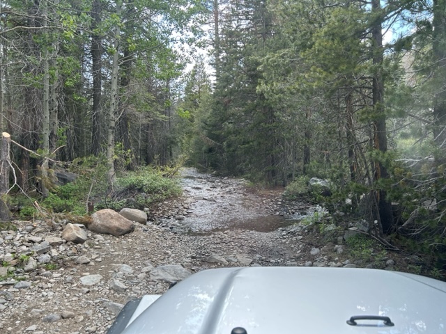
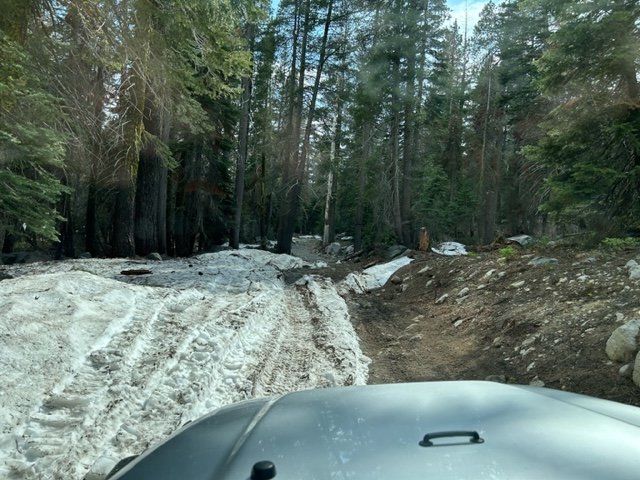
Snow, snow and more snow still on the trail.
I only got in as far as the pond at the turn for the Ellis Peak Trail. There is a lot of debris on the trail. Small trees across the trail in places. Many encroaching on the trail but not blocking the trail.

The further in you go, the higher you get, the more snow you will encounter.
There are some long stretches of water, snow, ice. No real mud at this point. Some were hardened underneath. This is just past Miller Lake before the turn to Sourdough Hill.

Unfortunately, I found a few spots where people had driven off trail to get around snow drifts. This is not acceptable. “Turn Around, Don’t Go Around”, that’s the motto of this website and should be followed by all. Please don’t be that guy.
The next time I’m on the trail, I will make an effort to block off all of these bypasses as I find them.
.
Rubicon Ronin

