
Rubicon Oversight Committee
Posted: May 22, 2018 Filed under: Maintenance | Tags: education, politics Leave a commentIf you don’t know the name, maybe you’ll recognize them as the R.O.C.
They want your input! And they’re coming to you to get it. Keep reading.
The ROC is El Dorado County’s effort to bring people together to better manage the Rubicon Trail. Vickie Sanders runs the show. She’s been making things happen on the Rubicon since the early days of FOTR. No one has done more for the Rubicon Trail than Vickie Sanders, no one.
The ROC meets every third Thursday of the month at the El Dorado County offices off Forni Road in Placerville at 8:30am. It’s great for those in the area of the western entrance to the Rubicon but not so convenient for the rest of us in Truckee, Tahoe City, Reno, Carson, Auburn, ETC.
Well that’s about to change. El Dorado County is taking the ROC meetings on the road.
From Vickie:
We will be holding several meetings of the Rubicon Oversight Committee at various locations in an effort to get the education and coordination message out to a broader group of interested parties. Please pass this information along. Let me know if you have any questions.
WE ARE TAKING THE ROC ON THE ROAD
Rubicon Oversight Committee (ROC)
PURPOSE:
- To educate a larger group of users on the educational program for the Rubicon Trail
- To discuss maintenance efforts and how we work on the El Dorado side of the trail
- To help facilitate maintenance activities in Placer County
- To get more clubs, groups and individuals involved
- To provide a holistic approach to the Rubicon
AGENCIES THAT WILL BE AVAILABLE:
- Tahoe National Forest
- Lake Tahoe Basin Management Unit
- Eldorado National Forest
- State Parks OHV Division
- Placer County Sheriff’s Office
- El Dorado County Parks Division
MEETING DATES, LOCATIONS AND TIMES:
May 30, 2018 – 6:30 p.m.
North Tahoe Event Center
8318 North Lake Blvd.
Kings Beach, CA 96143
June 4, 2018 – 6:30 p.m.
Murphy House at the Auburn State Recreation Area
501 El Dorado Street
Auburn, CA 95603
(El Dorado Street is HWY 193/49 as you head out of Auburn south towards the river crossing)
June 27, 2018 – 6:30 p.m.
(Tentative Location)
California Conservation Center
1949 Apache Ave
South Lake Tahoe, CA 96150
This is most likely due to the rumors that El Dorado County is looking to sign an MOU (Memorandum of Understanding) that would allow El Dorado County to manage the Placer County portion of the Rubicon Trail.
For the most part, this would be a very good thing. Vickie and El Dorado County has done wonders to mange, maintain and honestly, to keep the trail from being closed.
Placer County has been reluctant to step up their game and put more effort in to managing the Rubicon Trail. Placer has done things for the trail over the years but more needs to be done. El Dorado has demonstrated the willingness and ability to do just that.
My concerns are the actually being addressed by this mobile meeting plan. Over the years, the ROC has made many major decisions regarding the Rubicon Trail. If you weren’t in the room that day, you didn’t get a say in the decision. I drove to ROC meetings in Placerville, from Sparks NV, many, many times, as the Placer side user representative. It’s a 2.5 hour drive each way for a two hour meeting. It got old.
Once I stopped attending the meetings, I felt out of the loop. There were no efforts to continue to reach out to people not in the room. Even being on the email list for “all” things ROC, they didn’t reach out. The ROC made decisions that effected the Tahoe side of the trail and yet they didn’t reach out for input prior to the decision and implementation.
I am encouraged by this effort to reach out to the “other” side.
Let’s let Vickie, El Dorado County and Placer County know that the Tahoe side users care about the trail and we are willing to work with anyone and everyone that wants to better manage the Rubicon Trail.
Doug Barr
2018 FOTR Meeting
Posted: April 7, 2018 Filed under: Access, Maintenance | Tags: education, grant Leave a commentThe annual FOTR meeting took place this morning at the Metal Cloak facility in Sacramento.
There was a good turn out; a couple of speakers; elections; food; etc.
Important to the Tahoe Side, Eldorado County is looking to get in to a memorandum of Understanding with Placer County to mange the Placer County portion of the trail. Vickie Sanders, with Eldorado County Parks, has always been there for the Rubicon Trail. She has now formally stepped up to help manage the Placer side.
Let’s hope that goes through.
The agreement would allow Vickie to write a single grant that would cover the entire trail. The debate of why can they do that on their side and we can’t argument would be gone as the trail would be managed by one agency. FYI, the LTBMU is onboard with the new management possibility.
The Rubicon Trail Foundation is looking for a caretaker to manage their property this coming season. I believe I heard it will only be open on weekends June through Sept. This season might bring two cabins on the property which would allow a caretaker to stay throughout the week and keep the property open seven days a week. The property swap agreement to allow a road to the property requires a caretaker in order for the property to be open to the public.
Tahoe side to do were discussed. Priorities are going to be set and volunteers will be needed. Please contact the newly re-elected Trail Boss, Shannon Chard at LaughingPlace76@yahoo.com if you would like to volunteer to work on the trail.
If you did work on the Rubicon within Placer County last year, please document your hours and get them to Shannon or Kansas with Placer County. If you do work this coming season, again, get your hours to Shannon or Placer County. Your volunteer hours count as cash for matching funds the counties need to come up with in order to get grant money.
Work on Cadillac Hill has already been scheduled at the lower Hairpin. Jeepers Jamboree is leading that project.
John Briggs has stepped down from the Tahoe Side Lead position after three years of service. FOTR is looking for someone to take over this position. John and others will be helping out who ever takes on that position.
Rubicon Ronin
Storm coming in!
Posted: April 5, 2018 Filed under: Uncategorized Leave a commentJust an update on current conditions on the Tahoe side. 4-5-2018.
The pile of snow, curtesy of Placer County snow removal, has been over come on the right side. There not much of a climb.
Just over the berm there is a two-track heading up the trail.

There is a very wet storm headed in tomorrow, Friday, and hanging around through Saturday. Snow will melt away and what’s left will be very heavy. Great for wheeling, in the morning, but beware in the afternoon as it melts and gets very slippery.
Be safe!
Rubicon Ronin
Chinese/Japanese Rig Solid Axle Swap
Posted: April 1, 2018 Filed under: Maintenance, Travel | Tags: education Leave a commentI’m going to write this generically as I don’t want to bias anyone against any specific brand of rig based on my bad experiences.
Like most people, I started with what I could afford. Unfortunately, that got me a rig with an independent front suspension.
After some quality time off road, I realized some of the downfalls of an independent front suspension: ground clearance under flex, uneven tire wear, steering alignment, strength, complicated and thus expensive repairs, etc.
So, I finally decided to make the swap. I was going to pull out all the independent stuff and replace it with a solid axle.
Sourcing the solid axle was pretty simple. Pulling out the independent suspension was flat out going to be fun! The hard part was going to engineer the new solid axle into a rig not designed for it.
A before picture clearly showing uneven tire wear and the difficulty of keeping the steering aligned.


Off I went, out with the old, in with the new. I started by getting the rig up on jack stands for safety and all the old independent suspension parts were unceremoniously removed.

Here are the old parts next to the new solid axle that will be going in. I’m going to try and use as much of the old steering parts as possible.

The new solid axle doesn’t look much different from the side. But do note that I was able to use the old adjustable ride height system from the previous system.
But from the top you can already see the better alignment of the tires.

Underneath, where all the magic happened. It clearly shows the new solid axle and how much stronger it will be than the old independent system.
Here is an after shot after quite a bit of time getting everything just right. Measure twice, cut once. Back on all fours and ready for some off road travels.
So far the rig is night and day different. I goes straight with hands off the controls, it doesn’t pull at all when you initiate a turn. Once I get new tires for it, I expect the tires to wear evenly and last much longer.
After all was said and done, I would highly recommend this swap for anyone with an independent front suspension.

Rubicon Ronin
Snow, Maps, Paving & Kiosk
Posted: March 24, 2018 Filed under: Access, Maintenance, Travel | Tags: education Leave a comment On Friday, March 23rd, the FOTR Tahoe side lead (John Briggs) and I had two Rubicon meetings with local government agencies.
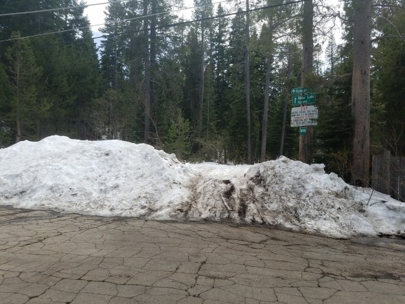
The first was meeting Placer County at the trailhead to discuss the snow being piled at the entrance. (The lead photograph)
When we got there, Lindsay from the county was already there. Looking around the area, it was obvious that there was more snow at the entrance than elsewhere in the neighborhood. Lindsay explained that she had talked with the plowing supervisor and that this was ‘normal’ for a “T” intersection as there was extra snow that needed to me removed from the intersection.
 After some discussion, I pointed out that this was not a “T” intersection but rather a “4-way” intersection. We agreed that what needed to happen was to move the pile 40 feet to the left. It would take no extra time or effort but would prevent piling snow on the Rubicon Trail.
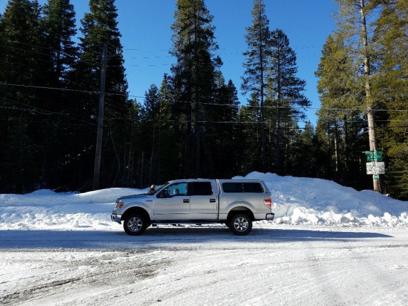 Now to be clear, the county will not be plowing the Rubicon Trail nor will they be removing the berm but hopefully, if the plow supervisor agrees, the pile (in the future) will be placed further left and if someone wants to play on the Rubicon, they will just have the ‘natural’ or ‘normal’ berm to deal with.
In addition, we discussed putting in two very tall snow stakes documenting the entrance so the plow drivers know where not to dump.

The snow had a very hard top layer after having rained several inches, then below freezing temperatures.
The second was meeting Mike Gabor of the Lake Tahoe Basin Management Unit (LTBMU) to talk about the new map they are developing and the new kiosk for the staging area, among other things.
This is a draft of the map under construction:

The new kiosk will have a 4’x8′ center panel for nothing but the new map. A 4’x4′ side panel on each side will hold additional material. It will be made out of mostly metal for longevity, not wood, and should last a very long time. If all goes according to plan (remember this is a government agency we’re dealing with), it could be up by the 4th of July.
THIS IS NOT THE ACTUAL KIOSK GOING IN. I JUST PULLED THE IMAGE OFF THE INTERNET TO GIVE VIEWERS AN IDEA OF WHAT COULD BE BUILT. THE ACTUAL KIOSK WILL HAVE MOSTLY METAL CONSTRUCTION.

There is an approved grant that will allow the LTBMU to pave the staging area. Before this happens, the Basin will be reaching out to the users for input on how to mark parking spots (size, spacing, direction), how to improve (harden) the border, how to best protect the trees within the staging area, signage, how to design an actual “staging area” for rigs coming off the trail or preparing to go out on the trail, etc. Figure the planning, design, layout, engineering and such will happen in 2018 and the actual paving will happen in 2019.
Rubicon Ronin

