
Challenging the Richardson Lake Trail
Posted: June 1, 2016 Filed under: Maintenance Leave a commentAfter dropping off the county and engineering firm employees, our group of four rigs headed back up the Richardson Lake Trail, 14N39.
Here is John Briggs going over the Rolling Dip installed in 2014 near the cabin. (To be clear, this is the old hunters or grazing cabin that has the tree in to the roof at Miller Meadow, not the Ludlow Hut much further up the trail at Richardson Lake.)

This is looking up the trail from the cabin.

Don and Galen crossing the Arizona Crossing.

We crossed this puddle but turned around just on the other side. The trail runs to the left of the trees in the center of the picture. I drove past them to turn around and slid down to them as I drove past. Pin striping by nature.

This is where we turned around. I had a nasty side hill which slid me in to some small tress along the side of the trail. This is looking up the trail not too far past the Arizona Crossing just past the cabin.
Note the side hill. Just around the corner in the distance, the trail climbs. That would not be fun. Also, it was three in the afternoon and we didn’t really have time to play.

On the way out, we decided to pull a log to the trails edge to prevent further travel off the trail. The snow drift doesn’t look like an issue in this photo but in previous trips John said the drift was six feet tall and really wanted to send you in to the sediment trap in the lower left corner.


Later in the year, we should move the log over a little more to better protect the two trees along the trail’s edge. This will be a stopping point early in the spring due to the shade that creates the steep side hill.
Remember, the snow will eventually melt. “Turn Around, Don’t Go Around”. Come back a few weeks later and the trail will be passable.
Another Day on the Rubicon
Posted: June 1, 2016 Filed under: Maintenance Leave a commentToday I worked with a group of volunteers and we took out some Placer County representatives and some employees of the firm Placer has hired to work on addressing the water crossings within Placer County. John Briggs of FOTR worked with Placer to organize the day. Don from the Tahoe Donner 4wdc was there along with Galen from the Hi-Lo’s.
The trail is very wet, many puddles along the trail. Tread Lightly! Please stay on the trail. Do not drive around snow drifts, downed trees or puddles. “Turn Around, Don’t Go Around.” Be prepared for anything.
The group was testing the equipment that will be used to GPS the Tahoe Side. They were also learning what the Rubicon Trail was all about.
This shot is looking east at the border between the Tahoe National Forest and the Lake Tahoe Basin Management Unit. Right at the end of all the water bars. It was the first snow we encountered on the trail.

Further up the trail, again looking east, just past Miller Lake. Sort-of deep water and snow drifts. Please keep your speed down when driving through water.

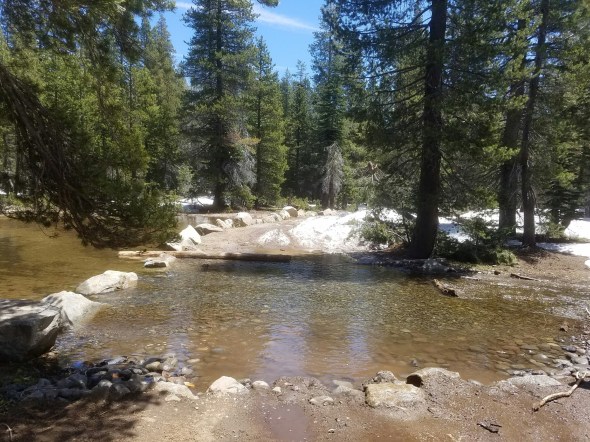
Here is the pond and the outlet, again looking east. Snow in the back ground on the trail. The log on the east side of the outlet has broken free and will need to be put back in place or replaced with boulders. It broke and was pushed out of place.
The trail up to Ellis has a snow berm at the entrance and I’m sure more snow in the shaded areas.

Further up the trail there were more snow drifts but we didn’t go any further. After dropping off the ‘workers’ at the staging area, we headed but up the trail to explore the Richardson Lake Trail.
Signs, signs, everywhere signs
Posted: May 26, 2016 Filed under: Access, Travel Leave a commentLast week I sat down with Susanne Jensen of the Truckee Ranger District of the Tahoe National Forest (TNF) to talk OHV trails for the 2016 season.
She has procured two new signs for the Rubicon Trail area.
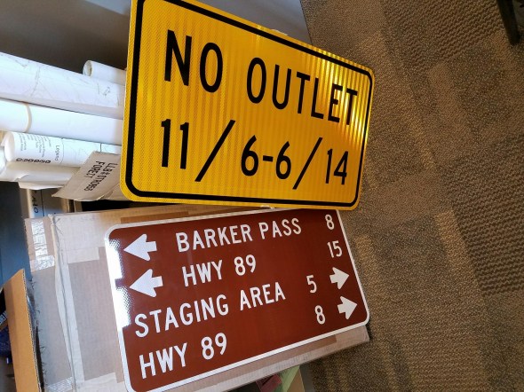
The first is for Forest Road 03-04 where it meets the Rubicon. As you come in from Tahoe, Forest Road 03-04 continues straight while the Rubicon is almost a 90 degree turn to the left. Forest Road 03-04 (if you continued straight) is closed seasonally from November 5th through June 14th. With this sign, we’re trying to prevent someone from thinking they can get out that way after November 5th and get lost, stuck or run out of fuel and not have anyone driving by regularly.
The second sign is for the same intersection but to be posted for those driving the Rubicon eastbound. This is a replacement sign as the original is long gone.
Susanne assured me there is funding to continue to install carsonite signs for all the side trails in the area. That will be one of my goals this season.
Headed out on the 1st and I’ll post up with a full report on the Rubicon and the side trails.
My Rubicon OHV season has started
Posted: May 11, 2016 Filed under: Access, Travel Leave a commentThis afternoon I took out my, new to me, Kawasaki KLZ250s, dual sport on the Rubicon Trail.
Now, I have quite a bit of Jeep experience and quite a bit of mountain bike experience but not much experience at all on a dirt bike. So, of course I decide to take out the bike on the Rubicon in early Spring with snow drifts, running water and a deep water crossing. Yes, I got wet but I didn’t fall over.
No snow to the staging area. I drove the truck and had the KLX250 in the back. While there I filled the “Free Maps” box with my flier and the RTF flier. After heading out of the staging area there was snow on the sides of the trail at the first climb, stalled it. Once on the flats, past the Buck Lake Trail (still closed until June 1st), it was easy going but only got to second gear.
Lots of water on the trail. Most all of it is in sections that are rock covered so erosion is minimal. Please stay on the trail and drive slowly through water.

A snow drift here and there with Jeep ruts in them. Still the motorcycle didn’t have much traction on the packed down snow, go figure.
Then there was water bar #8. Let me explain. None of the water bars are actually water bars, they are rolling dips. Well, WB # 8 is actually an Arizona crossing. That is a concrete lined water crossing. There are many along the Rubicon and a few on the Richardson Lake Trail.
WB#8 at full flow, which it was, is 18” deep, or more! I knew this going in and just barreled through in second gear. It’s got to be ten feet across. I got wet. Not really bad, but wet.
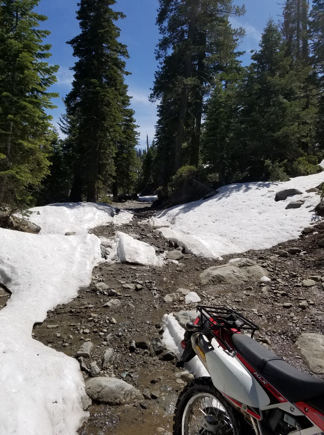
Again, the trail is very wet but in this area rock covered. Further up the trail, around water bar #11, the snow covered the entire trail.

Hiking up a little bit, to see how far the snow covered the trail, I saw it was impassable for my skill level. The trail was covered, side to side for about 100 yards. Then no snow for about 40 yards, then twin ruts in the snow. I turned around.

Headed down the wet slope, trying to figure out the foot brake versus compression braking, I approached the water crossing. This time I stopped and took a picture.

Back on the bike I was more nervous crossing this time that the first time. I stalled it twice just trying to get a quick start. I don’t know what I did differently, faster or slower, but I got wetter than the first time. But I made it.
The result of my scouting trip is to recommend that most users wait a few weeks before heading out on the Rubicon. The long snow drifts will cause most a lot of trouble. The better equipped rigs will be able to get up on the snow and Tread Lightly! I fear the less built rigs might spin their tires and dig up some sedimentation which will flow downstream.
Further up the trail, in higher elevation, there will be more snow. Deeper snow. Wetter conditions. Stay home and check over the wheeler: fluids, belts, charging system, cooling system, loose bolts, leaks, etc. Set up the camping gear and see where the mice stayed the winter. Wait until June to hit the Rubicon.
If you go and have trouble, take a strap or pull the winch out. A few shovels will also help. Let’s not give the anti-OHV people ammunition to use against our sport.
Monthly OHV Reports
Posted: April 12, 2016 Filed under: Access, Maintenance, Travel Leave a commentI just finished up-loading over a dozen OHV Reports I have presented to my local clubs over the last year and a half. I’ve created a link on the right side of the page under, of all places, LINKS.
As Vice President of two local 4wd clubs, I present a monthly report about what’s going on around the Tahoe area regarding OHV, including Deer Valley and the NV 4WD Association.
The reports are usually read to the members attending the meeting and I fill in a lot of details as I read and answer questions of the audience. So, the reports may read, not incomplete but sparse. It’s more of an outline.
Please feel free to ask me question about anything in the current minutes and I might not remember details from a meeting several months ago.
Here is the new page: OHV Reports (monthly)

