
Bing Maps Rubicon Closure
Posted: January 2, 2022 Filed under: Access | Tags: closure Leave a commentI often poke around the internet trying to find any new information on the Rubicon Trail. I specifically look for information on the Tahoe end of the trail. Surfing the internet is easier than an in person visit since I’m an hour and 20 minutes from the trailhead.
Here’s one of the latest things I found. I found it less than a week ago, so I waited until after the stated closure to post it. It has since been removed from Bing Maps:

“Closed road from Evergreen Way to Rubicon Trail. Start time: 11/3/2021 12:43am; Est. end time: 1/12022 12:00am.”
The red dashed line is the section of McKinney Rubicon Springs Road that is paved between the residential area and the staging area.
The map is from Bing Maps and the closure came up when I searched Bing Maps for ‘road conditions’. Someone had to input this information. I don’t think it’s worth reaching out to Bing Maps this time to ask who did this and why, but if it comes up again, I will definitely reach out to get it corrected.
Now in trying to figure this out, I thought it might have been done to prevent idiots from thinking they can drive to Sacramento on the Rubicon since Highway 80 and Highway 50 were both closed. But they were open when this closure was posted, 11/3/2021.
Recently, dozens of people have tried to drive through Dog Valley on Henness Pass Road to get over the pass even thought is does not get plowed. People in 2-wheel drive vehicles read their onboard GPS units and think they can use it. Local 4wd clubs have staged at the entrance to educate people about the road conditions there and to suggest that they turn around. Others have had to be rescued/recovered because they did drive down the snow covered road.
The Rubicon Trail is open year-round! Let’s all keep an eye on agencies or individuals trying to post that the trail is closed and speak up to get it corrected.
Happy New Year.
.
Rubicon Ronin
Tahoma Trailhead Conditions 12-30-21
Posted: December 31, 2021 Filed under: Access, Travel | Tags: snow, Tahoma, trailhead, winter Leave a commentOnce the highways opened up, after a record-breaking December snow fall, I ventured up to the Rubicon Trail trailhead in Tahoma to see what it looked like.
Before I could even get there, I had to drive through the neighborhood. Single track! The county plow had been through but only one time and right down the middle. It will take two more plow passes to clear the road and then the rotary blower will come through to clean up the edges.

From a distance, the trailhead looks unbreeched by wheeled vehicles.
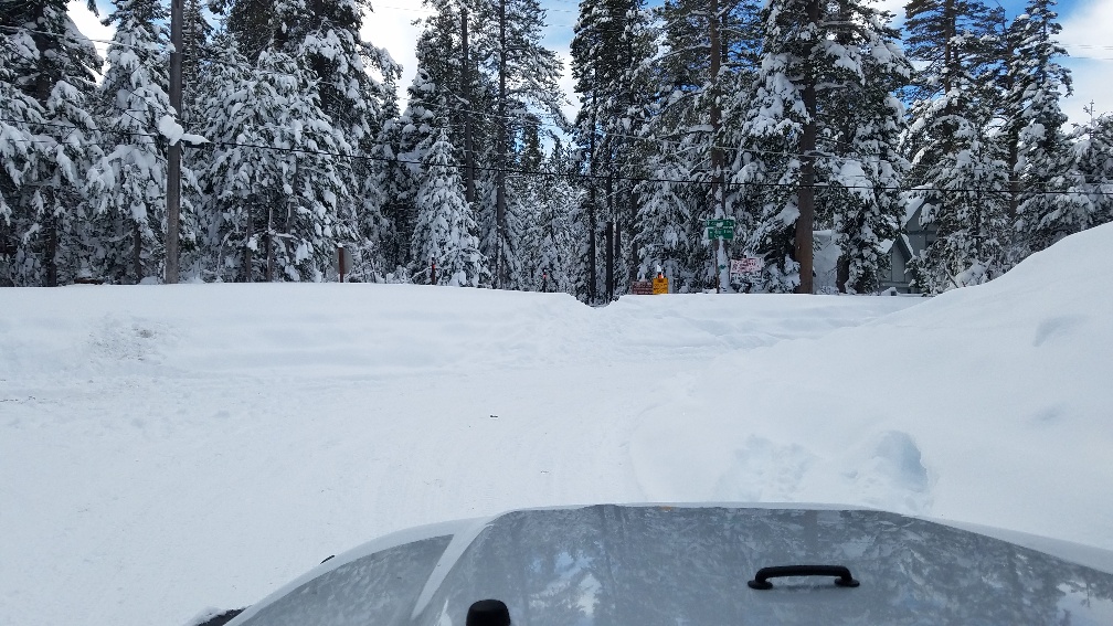
Sure enough, only one lone snowmobile track over the berm and up the trail. I did not have the time, nor the place to park, in order to snowshoe up the trail. But many snowshoe tracks already there.
There is a new trailhead sign. I don’t know who put it up but it has Forest Service colors.

My suggested signage for the trailhead was much more in your face:

(Yes, I realize there’s a misspelling in there)
Looking back from the trail, you can barely see the roof of my TJ with a 5″ lift on 35″ tires.

The berm is probably six feet tall, but once over the berm the snow is probably four feet deep.

So, I had to try it, but I knew if I made it over the berm I’d be stuck. Single vehicle; no way to winch myself backwards; but I did have a shovel with me. What the heck.

It’s a bad picture but it shows I didn’t get far.
Snow plow work is so far behind, understandably, that the entrance to the Sno-Park (Kaspian Campground) at Blackwood Canyon has not been plowed at all. FYI, no wheeled vehicle access from here, only snowmobiles.

The Rubicon Trail is open year-round. Only go if you and your rig are overly prepared!
Once the rotary plow comes through, there could be a five-foot face to the trailhead. Knock it down, make a ramp, go have fun. Stay on the trail. But beware as you exit, if there wasn’t a sheer face as you went in, there might be a sheer face on your way out. Walk it first.
Enjoy our public lands but be safe.
.
Rubicon Ronin
Snow on the Rubicon
Posted: October 28, 2021 Filed under: Access | Tags: snow gate, wall Leave a comment
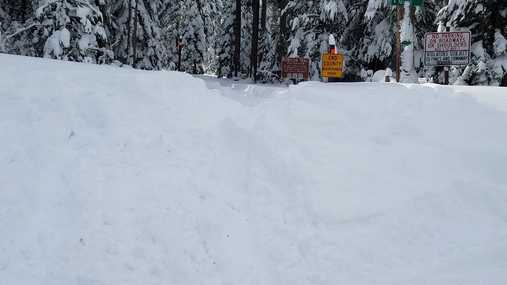
This picture was taken 10-27-21
Users of the trail had placed the orange snow stakes to delineate where the trail runs in order to keep users out of the ditch on the right because Placer County had rejected the idea. Now it appears that Placer County decided that it was a good idea and added the 4″x4″ poles and the “End County Maintained Road” sign.
I wonder why the county added that sign? There hasn’t been one of those there ever before. There are still unsolved issues about how the intersection is plowed and where that snow is pushed and piled up.
Always travel prepared to spend the night in case things go wrong: food, shelter, water, extra clothing, means to keep warm.
.
Rubicon Ronin
LTBMU reads my blog, opens the Rubicon!
Posted: October 17, 2021 Filed under: Access, Travel | Tags: caldor, fire, LTBMU Leave a commentOkay, I really don’t know if anyone at the Lake Tahoe Basin Management Unit reads my blog, but they did reopen the Rubicon just two days after my latest post.
Forest Service lifts Lake Tahoe backcountry closure early
Release Date: Oct 15, 2021
Contact(s): Public Affairs, Lisa Herron 530-721-3898
![[Image]: United States Forest Service Shield.](https://www.fs.usda.gov/Internet/FSE_MEDIA/fsm9_045805.gif) SOUTH LAKE TAHOE, Calif., Oct. 15, 2021 – The USDA Forest Service Lake Tahoe Basin Management Unit (LTBMU) Backcountry Closure Order (19-21-07), which temporarily closed Desolation Wilderness, Meiss Country and focused access corridors along the West Shore during the Caldor Fire, is lifted effective today, Oct. 15, 2021.
SOUTH LAKE TAHOE, Calif., Oct. 15, 2021 – The USDA Forest Service Lake Tahoe Basin Management Unit (LTBMU) Backcountry Closure Order (19-21-07), which temporarily closed Desolation Wilderness, Meiss Country and focused access corridors along the West Shore during the Caldor Fire, is lifted effective today, Oct. 15, 2021.
The Caldor Fire Emergency Closure Order (19-21-06) remains in effect through Dec. 31, 2021, for National Forest lands within and surrounding the fire perimeter. The closure order and map can be viewed on the LTBMU home page at www.fs.usda.gov/ltbmu. The public is advised that significant hazards remain within the Caldor Fire area including ongoing restoration activities, use of fire vehicles and heavy equipment, crew and aircraft activity, fire weakened trees and smoldering pockets of fuel. Please use the closure order description and map to stay out of the fire closure area. View the closure order and map at https://go.usa.gov/xM9Jy.
The following Desolation Wilderness trailheads that access south side areas within the Caldor Fire closure are still closed to public use for both overnight and day use access. Those trailheads are Rockbound, Twin Lakes, Lyons, Pyramid Creek/Horsetail Falls, Ralston, and Echo Lakes.
As a reminder, enhanced fire restrictions remain in effect for all National Forest lands in the Lake Tahoe Basin through Nov. 30, 2021. The Fire Restriction Forest Order can be viewed on the Forest Order webpage at go.usa.gov/xMXYK. Propane appliances with an on/off switch are permitted with a valid CA Campfire Permit.
In addition, closures on the Eldorado National Forest have been reduced, but many areas remain closed due to the Caldor Fire. For more information about the Eldorado National Forest, visit their website at www.fs.usda.gov/eldorado
.
My apologies for not realizing this sooner. It took the latest Caldor Fire Update, not including the LTBMU Back County closure, for me to get the information.
Here’ the twist. With the announcement that the LTBMU was extending the closure, the McKinney Rubicon Road was prominently mentioned in the brief heading for the closure. In the reopening press release, the McKinney Rubicon Trail is not mentioned in the preview paragraph or the main body of the order. I truly believe that the Lake Tahoe Basin Management Unit is anti-OHV and specifically anti-Rubicon.
The Eldorado National Forest sends of emails with OHV important information. I received an email when the Caldor closed the Eldorado and our other national forests. The LTBMU does not send out such emails. This should change. Our National Forest partners (?) should make an effort to keep the users and the general public informed. How hard would it be to notify RTF, Cl4, Blue Ribbon, local clubs? They already are part of an email group that discusses nothing but Rubicon issues. And yet they didn’t get the information out.
.
Rubicon Ronin
Rubicon Trail Still Closed
Posted: October 13, 2021 Filed under: Access, Travel | Tags: closed, closure, fire Leave a commentThe Lake Tahoe Basin Management (LTBMU) Unit still has the Rubicon Trail closed until October 20th.
- The Caldor Fire is 98% contained.
- There has been rain and snow over the entire area.
- Temperatures are ranging from the 20’s to the 60’s.
- The Rubicon Trail is open in Eldorado National Forest
- The Rubicon Trail is open in the Tahoe National Forest
- There are no strong winds forecast
Why is the Rubicon still closed?
Where is the Rubicon Trail Foundation (RTF)?
- RTF’s mission statement: “To Enhance the Future Health and Use of the Rubicon Trail, while Ensuring Responsible Motorized Year-Round Access.”
Why is RTF not ensuring our “year-round access”?
Does anyone fight for the Rubicon anymore? Is this the future of the Rubicon, seasonal closures due to possible fire conditions? If someone doesn’t push back, we will lose our trail during future summers as we’ve lost it this past summer.
FYI, if you go up to check out the trail status first hand, the bathrooms at the staging area are closed.
.
Rubicon Ronin

