
OHV trail markers
Posted: December 21, 2015 Filed under: Maintenance, Travel | Tags: education, Rubicon, TNF Leave a commentOne of my goals for the 2015 summer OHV season was to start marking every side trail along the Rubicon Trail and Forest Road 03-04 within the Tahoe National Forest (TNF). The US Forest Service (USFS) uses carsonite markers for most of these types of markers. These are the brown, three four foot long and four inch wide, fiberglass stakes.
Below is the marker for the Long Lake Trail that I didn’t get around to installing:

Having a USFS Motor Vehicle Use Map (MVUM) in hand while drive through our forests is great, it doesn’t help much if the intersections are not marked as to which trail is which. On the east end of the Rubicon Trail, you need three MVUMs to navigate the area: Tahoe National Forest (TNF), Lake Tahoe Basin Management Unit (LTBMU) and the Eldorado National Forest (ENF).
My flier combines the essential trails near the Rubicon Trail. See flier here
Working closely with Susanne Jensen of the TNF, we were able to put up thirteen markers along the Rubicon and Forest Road 03-04.


Next summer, we plan on completing the installation of trail markers on the TNF. I hope to work with the LTBMU and the ENF to ensure all trails in the area are properly marked.
LTBMU seeks input
Posted: December 7, 2015 Filed under: Access, Maintenance, Travel Leave a commentThe Lake Tahoe Basin Management Unit (LTBMU) is asking for our input. Although this is a scoping process and involves facilities as well as roads and trails, we need to read through this and comment.
I’ve only read it briefly and my first thought is to separate the facilities from the roads/trails within the document.
http://www.fs.usda.gov/detail/ltbmu/news-events/?cid=FSEPRD485271
LTBMU seeks input on proposal for roads, trails and facilities
Release Date: Dec 3, 2015
Contact(s): Public Affairs, Lisa Herron (530) 543-2815
SOUTH LAKE TAHOE, California – The U.S. Forest Service Lake Tahoe Basin Management Unit (LTBMU) is seeking comments on a proposal for the management and uses of existing roads, trails and facilities located on National Forest System (NFS) lands in the Lake Tahoe Basin.
The proposed action consists of four components: maintenance and management of roads, trails and facilities; authorization of outfitter guide activities; authorization of events; and authorization of special use permits for recreational uses on NFS lands. The proposed action complies with existing management direction found in the LTBMU Land and Resources Management Plan, existing rules, regulations, and administrative decisions regarding the use of NFS lands.
The proposed action identifies specific criteria and design features to establish thresholds on activities, which may proceed under the proposed analysis. An Environmental Assessment will likely be prepared, which will analyze activities considered appropriate to proceed under this project, under what conditions those activities may proceed, and any relevant design features that will reduce the risk to environmental, historic, social and recreational resources.
Comments are most helpful if received by January 15, 2016.
The proposed action is available at http://www.fs.usda.gov/goto/ltbmu/IntegratedMgmt.
For more information on the proposal and how to comment, contact Daniel Cressy at 530-543-2694 or email dcressy@fs.fed.us.
###
Fire restrictions lifted on the Eldorado National Forest
Posted: October 6, 2015 Filed under: Travel | Tags: camping, education 1 CommentThe Eldorado National Forest has lifted fire restrictions on the forest as of October 5, 2015.
Although the forest is still extremely dry, the fire danger was reduced by recent rains. I would suggest you don’t have a fire unless you actually need one. The risk/reward analysis does make a campfire worth the risk of a wildland fire.
Please be smart with fire. Read and obey the rules on the fire permit, which is required to have a campfire. Have water and a shovel at the fire just incase.
Truckee’s Fourth of July Parade
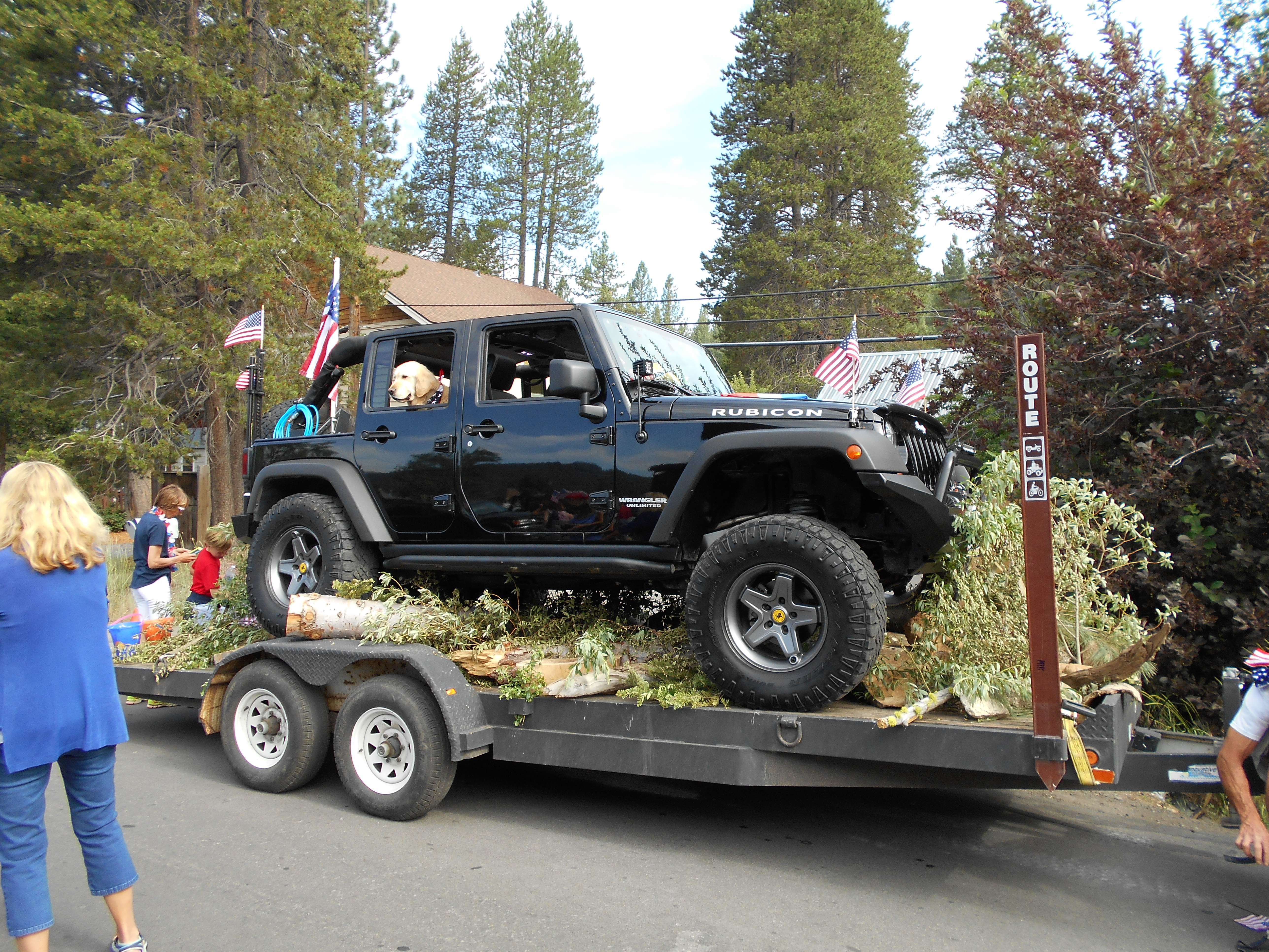
Posted: July 6, 2015 Filed under: Travel | Tags: access, education Leave a commentThis past weekend, I was honored to be invited to take part in the annual Truckee 4th of July parade.

The Tahoe Donner 4 Wheelers Club invited me to join them in the parade. This year’s parade focused on the TD4W Club’s Trails & Ales event this July 18th/19th. See the blog below for details or visit the TD4W website: http://td4wheelers.com/

The club had eight vehicles in the parade, two of them towing trailers. The first trailer was a flatbed with a Jeep poised on the trailer as if it were going down a trail. I liked the fact that they had a forest service (FS) carsonite stake stating that the trailer was an official OHV route. The second trailer was the Rubicon Trail Foundation (RTF) trailer being towed by me. I had re-rigged the airlines and had cracked the lowering valve on the trailer so I could raise the trailer while driving down the road and then the trailer would slowly lower itself.

For the most part, the parade went well. There were a lot of people there to watch. Fortunately, our group was toward the front of the parade.

As we exited the parade route, the rain started. No big deal as it was forecast for ‘showers’. We pulled in to the old lumber/rail yard on the east end of town and started to pull off the decorations. That’s when the skies opened up and started pouring rain. We worked faster. We had to get the decorations off from around the Jeep on the trailer and then the Jeep off the trailer.

Then the lightning started. And it was close. You count between the lightning and the thunder. Every five seconds is a mile. We had thunder within two seconds! And it was all around us. Some of us did not have hardtops on out Jeeps. At least I had a bikini top. A few didn’t have tops at all!

Latest Tri-forest OHV Rubicon Area OHV Trails map
Posted: May 19, 2015 Filed under: Travel | Tags: access, law enforcement, LTBMU Leave a commentHere is the latest version of a map that combines the three Motor Vehicle Use Maps (MVUM) from the Lake Tahoe Basin Management Unit (LTBMU), the Tahoe National Forest (TNF) and the Eldorado National Forest (ENF).
The TNF asked me to include ALL campsites in that section of the forest. Done.
The current TNF MVUM has a mistake. This map corrects that mistake. So this map is now more accurate regarding what trails are out there but not all of the trails listed are currently open. The Richardson Lake Trail is currently closed at the Pacific Crest Trail (PCT). The LTBMU trails do not open until May 30th.
It is the users responsibility to know where they are at all times and to know what trails are currently open to wheeled traffic. Contact the specific forest for details.


