
Rubicon Survey About Planned Parking Expansion
Posted: May 15, 2025 Filed under: Uncategorized | Tags: access, edc, parking Leave a commentI just got an email from El Dorado County (EDC) about a planned parking area expansion on the Tahoe side. Going to their website, you can get the same info. From the EDC website:
Take this Rubicon Trail Survey to let us know what you think about the proposed Rubicon Trail Parking Lot Expansion Project at the Tahoma staging area in the Tahoe Basin. The deadline for the survey is Friday, June 13, 2025, and will take less than 5 minutes to complete. Click here to learn more about the Rubicon Trail Parking Lot Expansion Project.(PDF, 173KB)
Here is the project description from NCE from the “learn more” link. NCE is an engineering firm with seven offices including Reno and Lake Tahoe.
Title: Rubicon Trail Parking Lot Expansion Project
Preliminary Project Description:
The Rubicon Trail is a highly valued off-highway vehicle recreational trail that passes through both El Dorado and Placer counties. It is located on land managed by El Dorado National Forest, Tahoe National Forest, Lake Tahoe Basin Management Unit, and includes private properties. El Dorado County has easements from the El Dorado National Forest and private property owners; however, no easements exist for the portion of the project in Placer County.
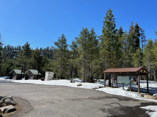
The Rubicon Trail has three major trailheads or access points. El Dorado County maintains the Loon Lake and Wentworth Springs trailheads. The Tahoma staging area, or access point, is within Placer County. Currently, when the parking lot is full at the Tahoma staging area, vehicle parking will occur along the road shoulder, which can lead to overcrowding and resource damage to the adjacent lands. Overflow parking further encroaches into nearby residential areas when the lot and road are full.
To address this issue, the Rubicon Trail Parking Lot Expansion Project would provide expanded parking at the Tahoma staging area on the Tahoe basin side of the trail. Disturbance would occur on approximately 0.91 acres and include 35,140 square feet of new paving. This will provide an additional 32-34 trailer parking spaces. There is also a desire to decommission and restore the existing small staging area along Rubicon Trail (1.25 miles northeast of the parking lot expansion area). Shoulder areas would be closed to parking. Additionally, the project team would like public input on the community’s interest in and/or concerns about a natural surface trail, parallel to the roadway, to provide alternative pedestrian access from the neighborhood to the Tahoma staging area.
The project team will complete technical studies to evaluate the environmental effects of the proposed project. The technical studies will be made available for public review, and a public meeting will be held to solicit feedback on the project and potential environmental effects prior to completion of required environmental documentation.
I’m assuming that the expansion would be behind the current kiosk, further up the trail. But again, I am only guessing as no map has been distributed yet.
The other portion of this proposal is to eliminate the lower dirt parking area once used by the ATV rental company. At the moment, I am opposed to eliminating this area. Once gone, it will never come back. A much further and deeper conversation needs to take place before I let that area go. Those visitors wanting to walk dogs or skate the paved section use this section without having to drive all the way to the staging area. It would also allow an option to parking in the residential area.


The last item is the construction of a natural surface trail parallel to the current paved section of McKinney Rubicon Springs Road. This is something I have suggested before. It would (should) eliminate any conflict between motorized and non-motorized users of the area. Think of it like a sidewalk on any road in the country. Hopefully, it would be designed, constructed and maintained for year-round use.
Here is a copy of the actual survey:
The Rubicon Trail is a highly valued off-highway vehicle recreational trail that passes through both El Dorado and Placer counties. It is located on land managed by El Dorado National Forest, Tahoe National Forest, Lake Tahoe Basin Management Unit, and includes private properties.
The Rubicon Trail has three major trailheads or access points. El Dorado County maintains the Loon Lake and Wentworth Springs trailheads. The Tahoma staging, or access point, is within Placer County. Currently when the parking lot is full at the Tahoma staging area, vehicle parking will occur along the access road shoulder, which can lead to overcrowding and resource damage to the adjacent lands. Overflow parking further encroaches into nearby residential areas when the lot and road are full. To address this issue, the Rubicon Trail Parking Lot Expansion Project would provide expanded parking at the Tahoma staging area on the Tahoe Basin side of the trail.
Please answer the following survey questions to help us understand what thoughts you may have, if any, about this proposed project:
Which option below best describes your living status:
Full-time Tahoe Basin resident, Part-time Tahoe Basin resident, Visitor, Other
Do you live within 3 miles of the Tahoe staging area?
Yes, No
How frequently do you visit the Rubicon Trail?
Weekly, Monthly, A few times per summer, Annually, Other
What season do you visit the Rubicon Trail?
Summer, Winter, Fall, Spring
What means of travel have you used to access the Rubicon Trail?
Off-highway-vehicle, Walking, running, or hiking, Biking, Other
Is a natural surface trail, parallel to the roadway, to provide alternative pedestrian access from the neighborhood to the parking area, an improvement you would like to include in the project?
Yes, No
Do you have any concerns about the project? Please select the option that best fits:
Emergency Access/Response, Private Property Concerns, Environmental, Other
Please provide any additional comments to expand on the previous question
(1000 words or less)
The survey takes no time at all. I’m questioning the local aspect. Does it matter where you live or for how long you’re there?
I took the survey and here’s why, if you don’t voice your opinion when it matters, you should complain later if it doesn’t go your way.
.
Rubicon Ronin
Springtime wheeling is here!
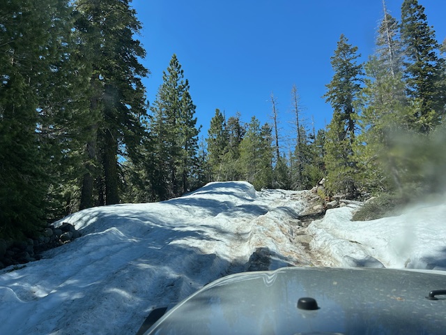
Posted: May 7, 2025 Filed under: Uncategorized | Tags: bathrooms, snow, springtime Leave a commentI made it out to the Rubicon today. There is still plenty of snow and plenty of water. Please Tred Lightly!

Sadly, even though I was told, by a very reliable source, that the bathrooms were open, they were not. It seems the local 4wd club who took on that responsibility has not been following through on their promise.

Yes, snow on the trail. This is the first climb out of the staging area. It will change daily as the temps will be in to the 70’s this week.
Don’t let springtime fool you, that same weather app says possible snow Monday into Tuesday! Always be prepared to spend the night on the trail: food, shelter, warm change of clothes, etc.

This is still the first climb out of the staging area. Not too slippery.
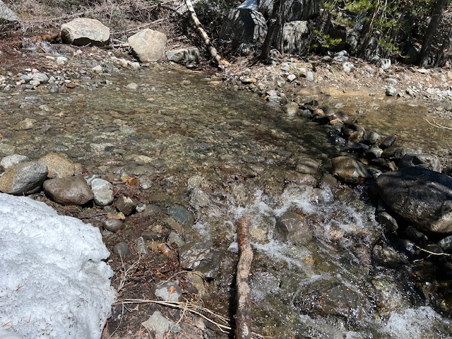
To be fair, once past this climb there were minimal snow spots. Until there were snow spots.
Well, I didn’t get too far. This is just past Water Bar (rolling dip) #19. This is where all the eight inch river rock is on the trail. I didn’t want to push my luck.

On the way out, I stopped at one of the many rolling dips. I think it was number seven. This one appears to have rocks piled to keep the water on the trail.

I spent maybe 20 minutes removing the rocks blocking the water from exiting the trail and throwing them where they block the water from running down the trail.
It made a huge difference. The next two weeks would be a great time for RTF, FOTR, LTBMU and Placer County to get out on the trail and survey the trail to determine where work parties should focus to prevent future lawsuits for water on the trail and running water causing erosion and sedimentation.
Get out there, have fun, be safe and be respectful to the trail and others.
.
Rubicon Ronin
Eldorado Forest Extends Seasonal Closures!
Posted: March 28, 2025 Filed under: Uncategorized | Tags: closure, rain, seasonal, snow Leave a commentEven though the snow pack for the Sierra is below average, the Forest Service has seen fit to extend the seasonal closure of OHV trails and roads. Typically, opening on April 1st, their trails will now open April 30th.
On the Tahoe side of the Rubicon Trail, this only applies to the Richardson Lake Trail that goes to Sourdough Hill.
 Eldorado National Forest Forest Service News Release Contact: Kristi Schroeder kristi.schroeder@usda.gov Seasonal Road and Trail Closure Extended through April 30 Eldorado National Forest Forest Service News Release Contact: Kristi Schroeder kristi.schroeder@usda.gov Seasonal Road and Trail Closure Extended through April 30 PLACERVILLE, Calif., March 27, 2025 — Based on recent and predicted rain and snow, the seasonal closure of dirt roads and motorized trails is being extended through April 30 on the Eldorado National Forest. Using motor vehicles on dirt roads and trails when soil moisture is high can cause damage to roadbeds from rutting, and impaired water quality from excess erosion. A minimum three-month closure period from January 1 through March 31 was designated for the core part of the wet season in the Eldorado National Forest Travel Management Plan. This plan also allows the seasonal closure to start earlier or be extended based on actual conditions. The roads and trails that are subject to the seasonal closure are marked with a “Seasonal Designation” on the current Motor Vehicle Use Maps (MVUMs) for the forest. The MVUMs are available from any forest office or can be downloaded from the forest website at: https://www.fs.usda.gov/detail/eldorado/maps-pubs/?cid=fseprd637014. The seasonal closure does not affect roads and trails in the Rock Creek Area near Georgetown which has its own wet weather closure process. For additional recreation information, contact the Visitor Services staff from 8 a.m. to 4:30 p.m. Monday through Friday: Forest Supervisor’s Office – 530-622-5061Georgetown Ranger District – 530-333-4312Placerville/Pacific Ranger District – 530-644-2324Amador Ranger District – 209-259-3774 ### USDA is an equal opportunity provider, employer and lender |
ENF OHV Grant “Virtual” Open House
Posted: February 25, 2025 Filed under: Uncategorized | Tags: ENF, grant Leave a commentSame as the Tahoe National Forest, the Eldorado National Forest is now looking for grant input. Actually, they are required to ask but not follow user input.
 |
| Eldorado National Forest |
| Forest Service News Release Contact: Kristi Schroeder kristi.schroeder@usda.gov |
| Eldorado National Forest Seeking Input on OHV Grant Applications |
| PLACERVILLE, Calif., Feb. 21, 2025 — The Eldorado National Forest welcomes public input to develop grant applications for State of California off-highway vehicle, also known as OHV, recreation funds. The Eldorado National Forest is developing California State Parks Off-Highway Motor Vehicle Recreation Division Grant Program preliminary grant applications this cycle to support facility maintenance, law enforcement patrols, and other work in support of OHV trails there. Public comments may be submitted for consideration by the following methods: In person during a virtual meeting on Feb. 27, 6 p.m. Dial-in option also available: 1 323-886-7051, Conference ID: 481 502 302# Email to Kristi Schroeder at kristi.schroeder@usda.gov with cc to OHV.Grants@parks.ca.gov after March 4 review online at olga.ohv.parks.ca.gov/egrams_ohmvr. Forest staff will use the public comments received for consideration as they develop the final grant application for submission in June. Reasonable accommodations may be requested through Kristi Schroeder at kristi.schroeder@usda.gov. For more information on the Eldorado National Forest, visit www.fs.usda.gov/eldorado. |
A Day on the Trail, on the Snow
Posted: February 23, 2025 Filed under: Uncategorized | Tags: snow, winter Leave a commentGood news, bad news. The good news is I got out on the trail with a bunch of my friends. The bad news is that MY rig didn’t make it. The story is not worth telling. So…
We got to the trailhead, in the residential trailhead as a group of four was heading out on the trail. A half an hour later, we headed out. The trail had been driven on a lot so it was well packed, in the ruts. Out of the ruts it was quite soft and deep.

The creek crossing were the difficult spots. A steep drop in and what seemed to be a steeper climb out, going both directions. Occasionally, there was a side hill on the trail and that made it difficult to stay in the ruts.
This was one of the easier crossing at the Arizona Crossing #8:
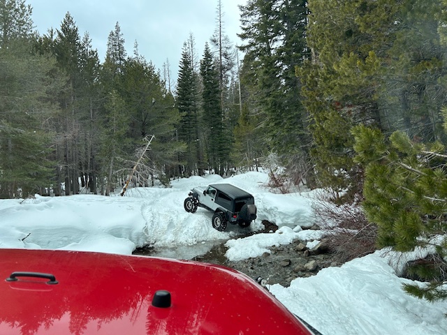
Straps were used, winches were used, but we all got up the trail. The trouble came when we ran into that other group headed out. Not exactly sure how far they got but we meet them before we got to Miller Lake.

We started turning our group around at both ends. It took some doing but we got it done. The drive out was uneventful.

Most of the rigs on the trail were on 37s. Everyone had an issue at some point.

No breakage, no injuries, overall a great day.
And there was a lesson learned. We all stop at the “staging area” to prep our rigs for the trail. What exactly do you do while staging your rig? Air down, lock your hubs, disconnect the anti-sway bar, etc.
My suggestion would be to make sure all possible needed tools and equipment are handy if needed. That means before you drive in to the deep creek crossing, dig the winch controller out of the back of your Jeep. Maybe plug in your winch and make sure it’s hooked up to your battery. I promised no names.
Be prepared, be safe, get out and have fun.
.
Rubicon Ronin

