Posted: August 21, 2015 | Author: Rubicon Ronin | Filed under: Access, Maintenance | Tags: 14N39, camping, ENF, maintenance |
Finally,
The Richardson Lake Trail, 14N39, is open!
| U.S. Forest Service
Eldorado National Forest
100 Forni Road
Placerville, CA 95667
Web: www.fs.usda.gov/eldorado
Twitter:@EldoradoNF
Facebook: www.facebook/EldoradoNF |
 News Release News Release
Contact:
Jennifer Chapman, (530) 957-9660
|
|
|
| For Immediate Release
Date: August 21, 2015
|
|
|
Upper Richardson Lake Road Now Open
PLACERVILLE, CA – The upper part of the Richardson Lake Road (14N39) on the Pacific Ranger District in the Eldorado National Forest is now open for motorized vehicle use, completing the final phase of corrective work on this route.
Richardson Lake Road is on the far northeastern end of the forest, and must be accessed through roads leading from the Lake Tahoe area. This 2.65 mile road is used to access Richardson Lake for camping and fishing, and travel to the top of Sourdough Hill to enjoy the scenic vistas, including a good view towards the Rubicon Trail. The route also provides access to the Pacific Crest Trail. A 4WD vehicle must be used to reach this road.
The first phase of work allowed the Richardson Lake Road to be re-opened up to the Pacific Crest Trail beginning in July 2014. Recently, improvements to the upper part of the road were completed in which a rolling dip was installed; an existing sediment basin was emptied and enlarged; and rock was placed over areas of bare ground. “These measures will help prevent erosion and protect delicate meadow ecosystems while allowing recreationists to enjoy one of the most popular motorized trails in the forest,” said District Ranger Richard Thornburgh.
The Richardson Lake Trail (14N39) was identified as one of 18 routes in the Eldorado National Forest travel system which needed corrections to comply with the environmental protection guidelines in the Sierra Nevada Plan. These routes were closed in 2012 to complete further analysis and make corrections to ensure the hydrologic connectivity of meadows would not be significantly impacted by motorized vehicle use.
Other routes which have re-opened after meadow protection work was completed are:
- Barrett Lake 4WD Trail – opened July 23, 2015
- Woods Spur, 10N01B – opened July 7, 2015
- Mud Lake section of the Carson Emigrant Trail is now open up to Mud Lake, 17E32, and Allen’s Camp – opened June 2015
- 09N08 Stockton Camp Road – opened September 2014
- 11NY32 47 Mile Road – opened October 2014
- 16E33 North Shanty Spur – opened November 2014
- 10N14 Mule Canyon – opened November 2014
- 10N13 Schneider Camp Road up to the new parking area near the old barn spur road – opened November 2014
For more information about work in progress to re-open additional routes, visit the Travel Management section of the Eldorado National Forest website at www.fs.usda.gov/eldorado.
-USFS-
|
|
Posted: June 6, 2015 | Author: Rubicon Ronin | Filed under: Maintenance | Tags: Cadillac Hill, camping, erosion, maintenance |
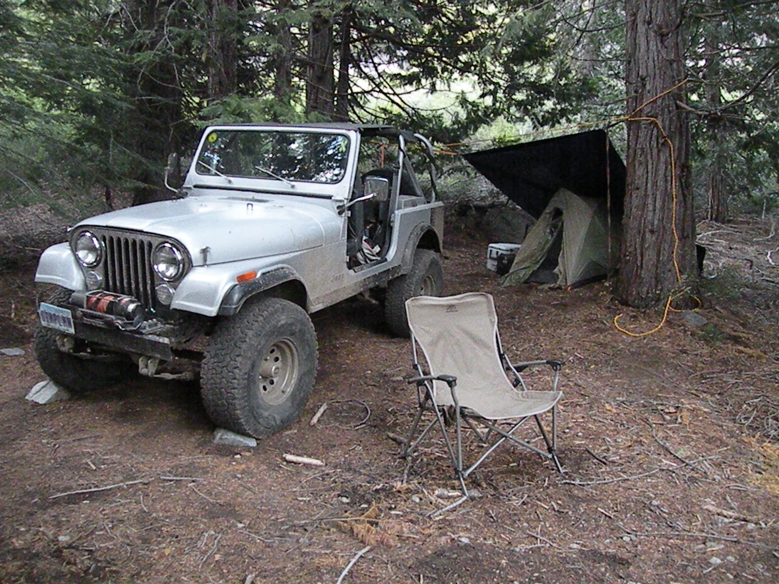
So, last week (June 4/5), I finally got out on the trail with the ability to focus on trail maintenance. Unfortunately, it didn’t go quite as planned.
The plan was to wheel in to the upper hairpin on Cadillac Hill, set-up camp, moving a bunch of rock to stop erosion, re-trench the upper creek crossing and evaluate what the lower hairpin needs.
The drive in was fine. I got a little hail at Observation. Light sprinkles from there down to the upper hairpin on Cadillac Hill. It stopped just as I started setting up camp. I wanted to make sure I had a dry camp before the predicted thunderstorm rolled in.

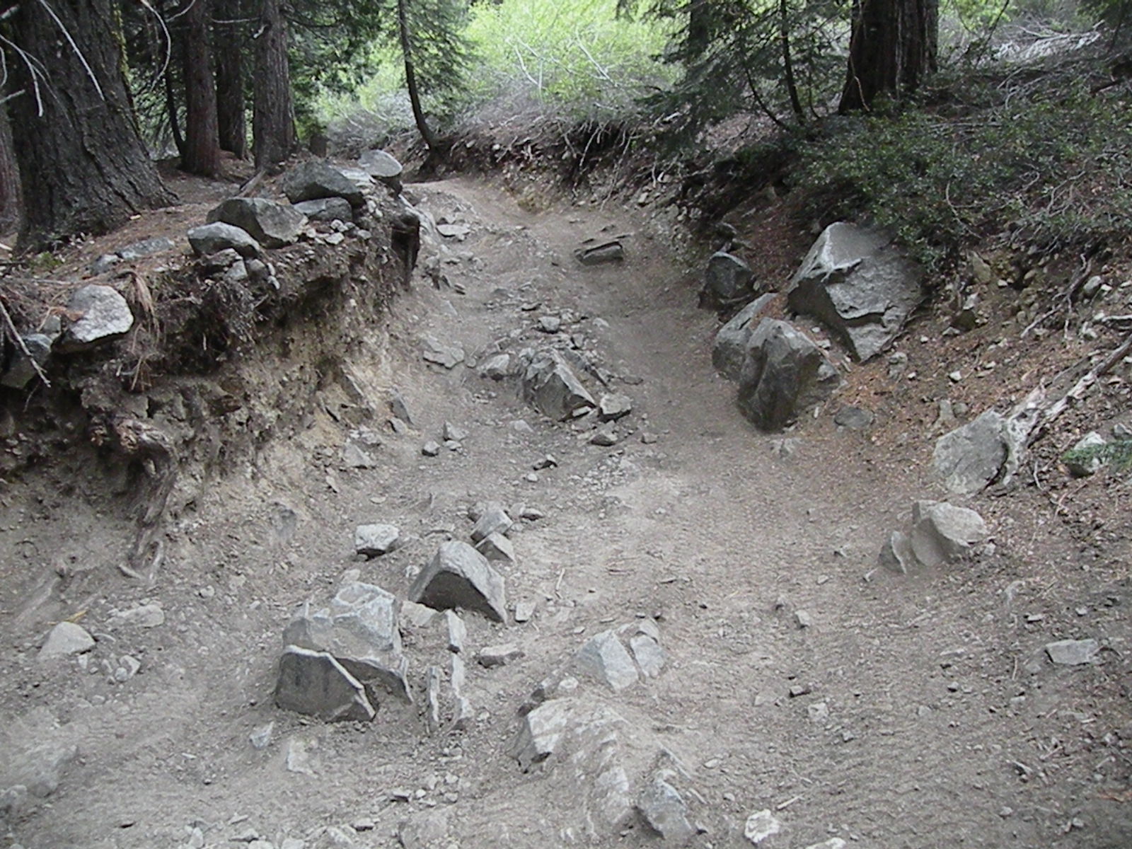
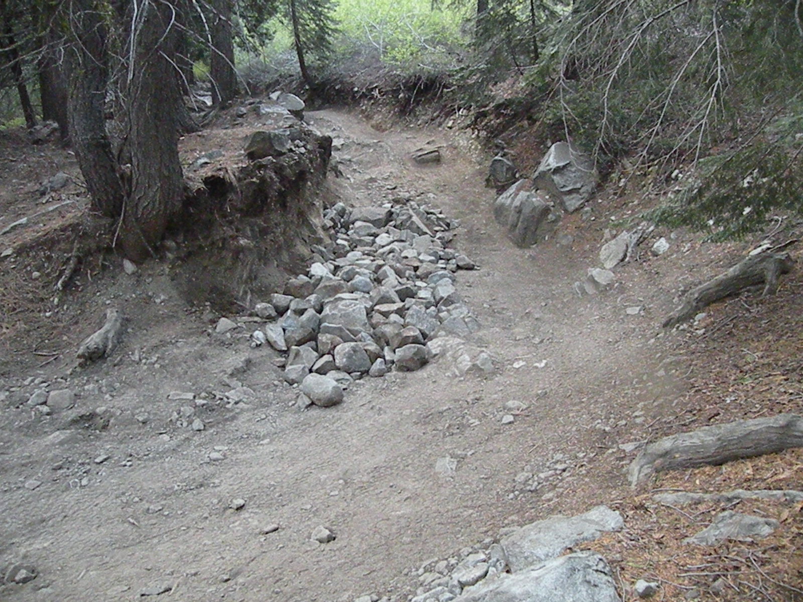
The first task was to harden the actual upper hairpin turn. As you can see, over the decades, there has been a little erosion taking place here. There are now a few differential busters that have ‘grown’ up out of the ground.

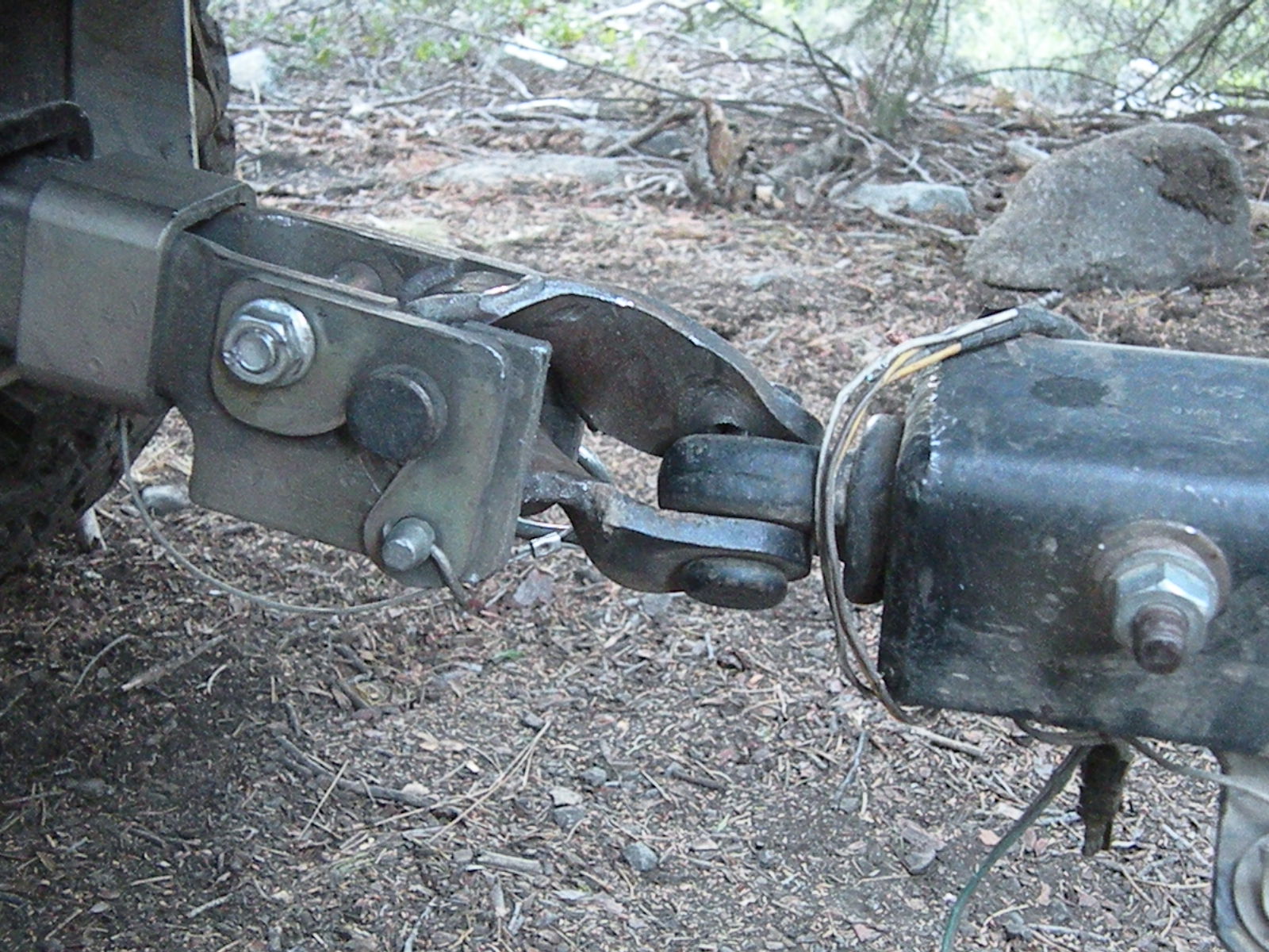
I took my ‘trusted’ trailer up the trail and collected rocks from off the trail. (No reason to weaken one section of the trail in order to harden another area.) On my third trip with the trailer loaded with rock, I noticed a bad noise. I stopped and checked the trailer connection.
For those of you not familiar with the “Lock-n-Roll” hitch, it provides full articulation in ALL directions. But after a few jack-knifes (on previous trips) and once running the hitch upside down, the hitch has seen a lot of abuse. This time, I took it a little too far.

I spent over an hour trying to re-bend the middle piece back in to position to give me full articulation. I had the trailer tongue strapped to a tree and my winch pulling on the hitch trying to straighten it out. Not too successful.
Update note: I called Great Basin Forge and explained my issue. Even though they don’t list parts for sale, they sold me only what I needed and got it shipped out the same day! Thanks guys.

So, I called it a day on hauling rock with only three loads delivered. As you can see, I did get a little done. At least the diff busters are minimalized.

I hiked up to the upper creek crossing and trenched the crossing a little deeper and further away from the log ‘water bar’. This almost immediately stopped any flow of water down the trail.
The growing puddle/hole above the step just above the creek crossing was also addressed but not completely. I hauled quite a few half full five gallon buckets of rock and dumped them in the hole. It will need more but I was running out of fuel for the day.
The next morning, before heading out, I walked down to THE hairpin turn and worked there for about an hour. Again, the flowing water was trenched away from the route that would let it flow further down the trail. This area will also need some follow up.
Once I get the trailer rebuilt, I’ll head back out and continue the projects.
Posted: April 26, 2015 | Author: Rubicon Ronin | Filed under: Maintenance | Tags: Barker Pass Road, camping, TNF |
Over the winter, I often wondered how to get more people, clubs, groups, businesses or individuals involved in OHV maintenance efforts.
With the release of the latest Motor Vehicle Use Map (MVUM) from the Tahoe National Forest (TNF), three new campsites were officially recognized along with Observation Point (for the first time) and Bear Camp just east of Observation.
I figured, if a trail can be ‘adopted’, why not a campsite? So, starting with these five (actually six) I started looking for volunteers.
Adopting a campsite is no where near as complicated as adopting a trail. Okay, maybe the paperwork is the same but the work load for actually doing the maintenance is much less. We’re talking about checking the site two or three times a year and ensuring that the trash is picked up, the fit pit (if it has one) is free of burnable items for five feet in all directions, the ashes are clean out and disposed of properly and that the size of the ‘campsite’ does not grow.
A few months later, I had three ‘groups’ lined up to adopt a campsite along with myself. That was four down, two to go.
I met with Susanne Jensen of the Tahoe National Forest as soon as she started her six month seasonal duties as the OHV Recreational Specialist on the Truckee District. Susanne was happy to welcome more volunteers to the TNF. She then pointed out there were a few more campsites along the Forest Road 003-004.
Four down, more like eight to ten to go!
So, this May, I will head out to GPS every campsite in the area of the Rubicon. I will update my map that combines three MVUMs from the TNF, ENF and the LTBMU to include all the campsites available for wheelers exploring the area.
That means the TNF will need a lot more groups to step up and adopt campsites. The sites along Forest Service Road 003-004 are a mile or so from the Rubicon but most have great views and much less traffic driving past them. Many are more hunting camps than wheeling camps but provide a great place to spend the night in the TNF.
So, if you would like to adopt a campsite, along the Rubicon or along Forest Road 003-004 (what I call Barker Pass Road), let me know. I’m currently the liaison between any group adopting a campsite on the TNF near the Rubicon and the TNF.
So far, we have the following groups adopting the listed campsite:
- Jon & Jan Briggs – the elevated camp west of Miller Lake FS#-3010-026
- (The camp with the fallen snag is available to be adopted – FS#-3010-024)
- Tahoe Donner 4wd Club – the turn out area at Miller Lake FS#-3010-022
- Doug Barr / http://www.TheOtherRubicon.com – no FS# (the camp on the far west end of Miller Lake)
- Sierra Stompers – Bear Camp FS#-16E77
- (Observation Point is still available – FS#-16E78)
- There are many along Forest Service Road 0003-004 available for adoption