
Good news, bad news.
Posted: March 29, 2014 Filed under: Access | Tags: 14N39, ENF, Richardson Lake Leave a commentThe good news is…
On April 1st, the Eldorado National Forest will allow the scheduled opening of its OHV trails that were closed for the “wet” season. The forest has the option of extending the seasonal closure if they feel the trails are still too wet.
The bad news is…
The only ENF trail that is near the Rubicon on the Tahoe side, 14N39 The Richardson Lake Trail, remains closed due to four sections of the trail not meeting “Standard & Guideline 100” for meadows.
My goal is to work with the ENF and Reno/Tahoe volunteers to get at least the first three ‘meadow’ issues fixed. Optimistically, I’d love to see them open for Memorial Weekend; Fourth of July at the latest. As for the last ‘meadow’, I’d love to see a temporary fix in place before the end of the season. That section will require a reroute and that will take YEARS to finish.
Rubicon Trail reopens!
Posted: March 21, 2014 Filed under: Access, Maintenance | Tags: El Dorado County, FOTR, Rubicon Leave a commentEl Dorado County has reopened the Rubicon Trail.
FOTR will work the problem section this summer to prevent future closures.
Unless there is a heavy rain storm, the trail should remain open.
Trail Conditions…
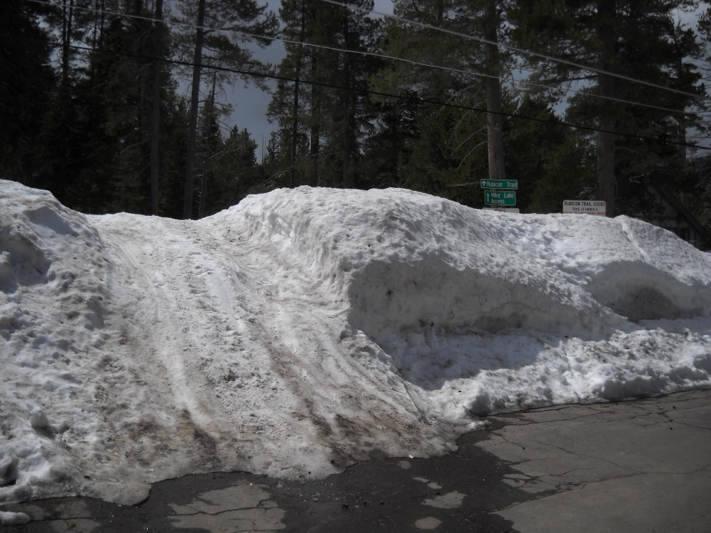
Posted: March 18, 2014 Filed under: Access | Tags: Rubicon Leave a commentI was at the lake yesterday and stopped by the Rubicon. See the photo of the week.
The paved section had snow but also two ruts down to the pavement all the way to the staging area. My 31″ tires had no problem getting me to the staging area but the trail past there was a different story. I tried to drive up the trail and the ruts became deeper. A few of the “potholes” in the ruts caused my front end to bottom out.
I turned around before the first climb but that climb was icy and very slippery. I can only assume there are patches of snow and dirt further up the trail. There have been reports that Cadillac Hill is dry and that there are some snow berms along the trail.
This time of year the trail is fragile. Please do not drive off trail to get around the snow berms or water holes. These actions will damage the forest and give ammunition to the anti-OHV crowd to use against us to close our trails.
Turn around, don’t go around!
The “Who’s Who” of the Rubicon
Posted: February 17, 2014 Filed under: Access | Tags: El Dorado County, ENF, LTBMU, Placer, TNF Leave a commentWho’s Who? A look at the government agencies, clubs, organizations, forests, property owners, representatives, counties and water districts that affect or govern the world famous Rubicon Trail
Alright, this article grew to be longer than I thought as there are far more interested parties regarding the Rubicon than originally thought. That and I tend to go overboard. In no particular order:
Counties
The Rubicon Trail spans two counties, Placer County (PCo) in the east and Eldorado County (ElDoCo) in the west. The dividing line on the Rubicon Trail is the north border of the “Rubicon Springs” property. Both counties are involved with managing the Rubicon Trail. Below are links to the Rubicon Trail pages for each county.
Placer County Rubicon page:
http://www.placer.ca.gov/departments/works/mckinneyrubicon
El Dorado County Rubicon page:
http://www.edcgov.us/Government/Rubicon/Information_to_the_Rubicon_Trail.aspx?terms=rubicon%20trail
Rubicon Oversight Committee
El Dorado County has a long established committee that deals with nothing but Rubicon Trail issues called the Rubicon Oversight Committee (ROC). This has been a huge help to getting things accomplished by both the county and the users. The county run meetings are monthly meetings are attended by county officials, FOTR, RTF, users, anti-OHV people, sometimes state officials and other interested parties. The meetings are open to the public and held on the second Thursday of each month at the ElDoCo facilities in Placerville.
The county supervisors for each county are:
Jennifer Montgomery
Placer County
175 Fulweiler Avenue
Auburn, CA 95603
Norma Santiago
El Dorado County
330 Fair Lane
Placerville, CA 95667
Key county workers:
Placer County – Kansas McGahan, Senior Civil Engineer, works out of the Kings Beach office at Lake Tahoe.
El Dorado County – Vickie sanders, CAO Administrative Analyst at the County of El Dorado, I think is now in charge of ALL parks/trails within ElDoCo. A Donna Mullens is now the one sending out the minutes and agendas for the ROC meetings.
Forests
The Rubicon Trail crosses three ‘forests’: the Eldorado National Forest (ENF), the Tahoe National Forest (TNF) and the Lake Tahoe Basin Management Unit (LTBMU, technically not a forest). The Rubicon crosses the border between the ENF and the TNF at Miller Creek at the bottom of Cadillac Hill. The Trail crosses from the TNF to the LTBMU east of Miller Lake. (When you see an Arizona crossing with rocks imbedded in it, from there east is the TNF). The TNF is working to replace the sign that was once there.
Lake Tahoe Basin Management Unit (LTBMU)
Home http://www.fs.usda.gov/ltbmu
Rubicon http://www.fs.usda.gov/recarea/ltbmu/recreation/ohv/recarea/?recid=11829&actid=93
Nancy J. Gibson is the Forest Supervisor
(Still working on who should be THE contact for Rubicon issues)
Tahoe National Forest (TNF) – Truckee District
Home http://www.fs.usda.gov/tahoe
Rubicon http://www.fs.usda.gov/recarea/tahoe/recreation/ohv/recarea/?recid=56204&actid=93
Tom Quinn is the TNF Forest Supervisor
Joanne Robique is the Truckee District Ranger
Susanne Jensen is the seasonal OHV Recreation Specialist for the Truckee District
Eldorado national Forest (ENF) – Pacific Ranger District
Home http://www.fs.usda.gov/eldorado
Rubicon – The ENF does not have a Rubicon page
Lawrence Crabtree is the Forest Supervisor
Richard Thornburg is the Pacific District Ranger
Debbie Gaynor is the Recreation Specialist for the Pacific District
Water Districts
This is where things really got started back in 2000. A complaint was filed and the Lahontan Water Board stepped in to make sure the Rubicon Trail was not harming the water entering Lake Tahoe. Years later, a similar complaint was filed with the Central Valley Water Board for that watershed. Both efforts failed to close the trail but instead brought funding to maintain the Rubicon Trail.
The Lahontan Water Board manages the Lake Tahoe Basin watershed and thus covers the LTBMU. The Central Valley Water Board covers both the TNF and the ENF sections of the Rubicon Trail.
Lahontan Regional Water Quality Control Board
http://www.waterboards.ca.gov/lahontan/
Central Valley Regional Water Quality Control Board
http://www.waterboards.ca.gov/rwqcb5/
State (wide) agencies
CA State Parks – Off Highway Motor Vehicle Recreation (OHMVR)
State Parks are involved in the Rubicon Trail by providing grant funding to the national forests, and non-profit groups and by providing law enforcement as needed for the Rubicon Trail and all other OHV trails in the state.
Grant contact – George MacDougall
LEO Contact – Brian Robertson
CA Association of 4 Wheel Drive Clubs (Cal4)
Cal4 has been around for a VERY long time, if you’re not a member, sign-up now. They are THE agency that allows scores of clubs to stand together to fight for OHV access on public lands.
Nevada 4 Wheel Drive Association (N4WDA)
These guys are new to the scene. There have been Nevada state organizations around before but they didn’t last. With the new OHV registration requirements in Nevada, there was a need to have a formal group to work with those collecting the money to make sure it goes to OHV needs and not in to the general fund. There are also access fights to be fought, like the grouse issue, in Nevada.
Government (elected) Representatives
Governor
Jerry Brown
Senators
Barbra Boxer
Dianne Feinstein
State Representative for the Rubicon area
Ted Gaines – State Senator
Brian Dahle – State Assembly
Frank Bigelow – State Assembly
US Representative
Tom McClintock
Volunteer Organizations
Friends of the Rubicon (FOTR)
Rubicon Trail Foundation (RTF)
www.RubiconTrailFoundation.com
Country wide agencies
Blue Ribbon Coalition (BRC)
Tread Lightly!
United Four Wheel Drive Association
Private Property owners
Rubicon Soda Spring Incorporated (RSSI)
(Sixteen or seventeen owners in this group)
The half section that is the “Rubicon Springs”
Rubicon Trail Partnership (RTP)
(I think there are only six people in this group)
East half of the Spider Lake area
Auburn Jeep Club – private parcel
Five acres between Ellis Creek and Walker Hill
Rubicon Trail Foundation (RTF) – not yet open to vehicle traffic, working on an easement
The half section between the Spider section and the Rubicon Springs section
There are many other privately owned parcels along the Rubicon but these are the groups I had information on and that are known to support OHV use.
Disclaimer: I know this is NOT a complete list of everyone out there that is helping or at least interested in the Rubicon Trail. If you feel your organization should be on this list, send me the details and I’ll add you.
The Story of the Snow Gate
Posted: January 12, 2014 Filed under: Access, Travel | Tags: LTBMU, Placer, Rubicon Leave a comment Once upon a time, like 1999-2000, some very anti-OHV people tried to close the Rubicon Trail. They argued that Jeeps crossing seasonal creeks caused erosion and released sediment which found its way to Lake Tahoe. The only solution they saw was to close the trail.
In 2000, FOTR was formed. In 2001, 1800 cubic yards of crushed rock was placed at 28 newly built rolling dips at each seasonal creek crossing on the Rubicon Trail. This was not enough for the anti-OHV people. They argued that the rest of the trail was still wet and they wanted a gate to close the trail after the first rain of the fall that was to be opened only after the trail had completely dried out.
The private property owners said they would have to have a key to that gate and that after receiving that key they would make copies for their 10,000 closest friends. The county needed another solution.
A snow-gate was proposed. The snow removed from the neighborhood streets would be piled at the entrance to the Rubicon throughout the winter, thus creating a “snow” gate and preventing winter use of the Rubicon Trail. Come springtime, once the HUGE pile of snow had melted, the assumption was that the trail would be dry enough for wheeled use.
More than a dozen years later, equipment improvements have allowed wheelers to use the Rubicon year-round. The trail never officially closes. Wheeling over the snow is probably the most ecologically friendly type of wheeling as you’re leaving tracks on several feet of snow that once it melts, you’ll never know anyone was there.
Snow is still piled at the entrance but if you have a capable enough rig, you can legally drive over the ‘snow-gate’ and access the Rubicon Trail.
John Arenz, of RTF, has compiled a list of things to carry with you while winter wheeling:
- SIGNALLING PANEL, Ultra High Visibility, two color 24” x 69” heavy duty nylon (1)
- SLEEPING BAG, mummy style w/compression stuff sack (1 for each person)
- TENT, 6 person (1)
- SLEEPING PADS, insulated (1 for each person on board
- WATER PURIFICATION TABLETS, germicidal, (25 quart )
- HAM RADIO, dual band, w/ clamshell battery and spare AAA’s
- GPS, portable
- SNOW SHOES (1 pair for each person)
- COMPLETEOUTDOOR CLOTHING (for each person)
– Full gore-tex shell
– Full inner layer
– Spare socks
– Snow boots
– Insulated gloves (2 pair)
– Snow hat
– Ski goggles
– Day pack
– Water bottle
- BUTANE LIGHTER, visible reservoir without childproof lock
- STROBE, red, emergency signaling w/industrial ‘D’ cell battery
- ALUMINUM SNOW SHOVEL (2)
- CHAIN SAW, minimum 24” bar, w/ spare fuel and chain
- FOLDING SAW, portable
- SIGNALING MIRROR, Unbreakable
- FLASHLIGHT, LED (2)
- SHELTER TARP, polyethylene reinforced/grommeted 16’ by 20’
- SUNSCREEN, SPF 30 or better
- SIGNAL FLARE GUN, w/ 12 flares
- MEAL, READY TO EAT, Assorted Menu (6 Each)
- HI CALORIE DRINKS, powder (6 quarts)
- STOVE, portable camp
- POT, portable camp
- FLARES, 15 minute for fire starting and/or signaling (6)
- COMPASS, Lensatic
- REPAIR WIRE, four-spool stainless
- LOW TEMPERATURE BLACK TAPE, ¾” x 66’ Roll (2)
- SURVIVAL WHISTLE, Dual Chamber with Hypothermia Lip Guard
- LOW TEMPERATURE RED “100 MPH” TAPE, 2” x 20 Yards
- STORMPROOF MATCHES, With Sealed Striker (Box Of 25)
- SPACE BLANKETS, silver 54” x 84” (4 each)
- PARALINE CORD, 650#, 100 feet
- POLYETHYLENE BAG , orange, multiple use, 38” x 38” 2.5 Mil (6)
- AXE, one piece
- DUFFEL BAG, High Visibility
- HAND TOOLS
- SPARE PARTS BOX
- WELDER (underhood, Premier, with cables, hood, and tools)
Those anti-OHV people still monitor what happens on the Rubicon Trail. If you go during the winter, Tread Lightly! Cross country travel is only allowed by factory tracked vehicles. Don’t spin your tires as you transition from water crossings to snow. Winch more frequently than you think you should.
Let someone know where you are going and when you plan on returning. Carry all of the stuff listed above and more, like tools and spare parts. Never wheel alone or as a single vehicle.
And my personal favorite and this website’s motto: Turnaround, don’t go around.

