
ENF Closes Trails Early
Posted: December 2, 2022 Filed under: Access, Travel | Tags: closure, rain, winter Leave a comment U.S. Forest Service Eldorado National Forest 100 Forni Road Placerville, CA 95667 530-622-5061 www.fs.usda.gov/eldorado  News Release For Immediate Release December 2, 2022 Media Contact: Jennifer Chapman, jennifer.chapman@usda.gov www.facebook.com/EldoradoNF Twitter:@EldoradoNF Seasonal dirt road and trail closure begins December 1 on the Eldorado National Forest PLACERVILLE, Calif. – Due to the amount of rain and snow received, the annual seasonal dirt road and trail closure for motorized vehicles went into effect December 1, 2022 on the Eldorado National Forest. The seasonal closure is designed to protect roadbeds and watersheds from damage and to protect water quality. A minimum three month closure period from January 1 through March 31 was designated in the Eldorado National Forest Travel Management Plan for the core part of the winter. To maintain flexibility, the timing of the seasonal closure is determined based on current conditions each year which may cause the closure to go into effect early or be extended. This year, storms saturated the soils in November with rain and melting snow making dirt roads and trails susceptible to rutting and erosion. Regardless of when the closure is in effect, visitors should always use good judgement about whether motor vehicle use will cause resource damage. The roads and trails subject to the seasonal closure are identified on the forest’s Motor Vehicle Use Maps (MVUMs) which are available free of charge and can also be found on the forest website at: https://www.fs.usda.gov/main/eldorado/maps-pubs . The seasonal closure does not affect routes in the Rock Creek Area of the Eldorado National Forest near Georgetown, which has its own route closure process. For more information on recreation opportunities and current conditions in the Eldorado National Forest, visit the forest website or contact a Visitor Information Specialist Monday through Friday from 8:00 a.m. to 4:30 p.m. at: · Forest Supervisor’s Office: 530-303-2412 · Amador Ranger District: 209-259-3774 · Placerville and Pacific Ranger Districts: 530-644-2324 · Georgetown Ranger District: 530-333-4312 ### The U.S.D.A Forest Service is an equal opportunity employer. The mission of the Forest Service is to sustain the health, diversity, and productivity of the nation’s forests and grasslands to meet the needs of present and future generations. |
This early closure would only include the Sourdough Hill Trail on the Tahoe side and all other trails in the ENF.
For the record, the LTBMU closes their trails Nov 15th.
.
Rubicon Ronin
Winter is here, and at the Rubicon
Posted: November 4, 2022 Filed under: Access, Travel | Tags: bathrooms, plowing, snow Leave a commentSnow has arrived on the Rubicon Trail. But it looks like Placer County has yet to figure out their 2022-23 plowing routine…

But the push of extra snow toward the trailhead has begun. The true plow line should be right up the middle of the photo below.

Proof my Grand Cherokee went ‘snow wheeling’.

For the record, it doesn’t have a whole lot of ground clearance! Yes, I was scraping the snow in spots.

But it was gorgeous up there. And the bathrooms were unlocked.

Please be safe out there. Remember to pack food, water, extra clothing, a shovel, recovery equipment, etc. Be prepared to spend the night. Don’t go alone. Let someone know where you are going and when you will return. Carry a ham radio.
.
Rubicon Ronin
Fire Restrictions in Place!
Posted: July 11, 2022 Filed under: Access, Travel | Tags: fire, restrictions Leave a commentAs of this writing, the Eldorado National Forest (ENF) has implemented fire restrictions regarding the use of fire, stoves and tools within their forest.
https://www.fs.usda.gov/Internet/FSE_DOCUMENTS/fseprd1042394.pdf
The owners at Rubicon Springs have also implemented a no campfire rule for the rest of the summer.
No word yet from the Tahoe National Forest but I’m sure it’s coming soon.
Please be fire safe any time you’re out enjoying our national forests.
.
Can My Rig Make It?
Posted: June 22, 2022 Filed under: Access, Travel | Tags: difficulty, trail rating Leave a commentI get this question quite often and recently ran in to it on another website. Let me do my best to answer that question. The problem is there is no easy answer. Driver skill is a huge factor in whether or not you can make it, or more specifically, make it without damage.
Here it is, the last piece of pavement before hitting the trail.

Just a very short drive up the trail, 0.3 miles to be specific, there is what some refer to as a “gatekeeper”. But it’s not. It is a very easy example of what your rig should be able to drive over if you want to run the Rubicon Trail. In the picture below, I stayed on the trail but went around the ‘gatekeeper’.
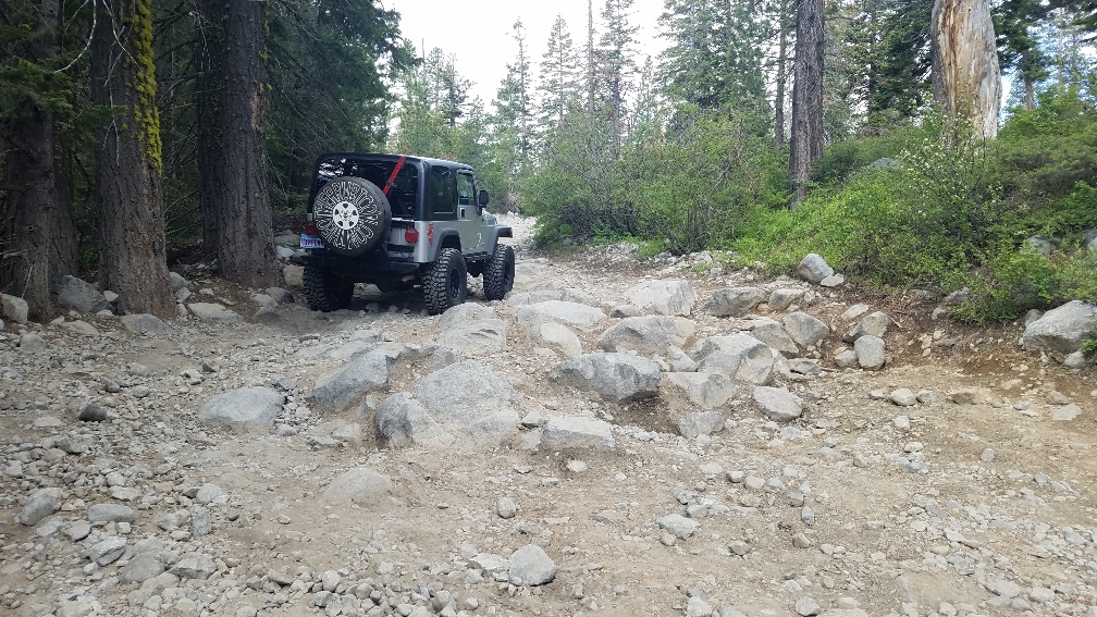
Further up the trail, here is an example of what a lot of the first four miles look like on the Tahoe side. Most of these rocks are more of an inconvenience than a challenge to any high clearance vehicle.

The trail is off and on rocky. After the gatekeeper, this is one of the trickier sections on the way to Miller Lake.

Typically, there are just enough rocks in the trail to prevent users from driving too fast.

Currently, there are many wet sections within the Tahoe National Forest. There is often standing water in this area. Some of the puddles are deep but most of them rocky bottom.

Just over four miles from the staging area is the turn at the “Y”. At the “Y” is mile marker 11.5, that marks 11.5 miles to Loon Lake. Going straight will take you to Barker Pass on Forest Road 03-04. Turning left keeps you on the Rubicon Trail (16E75). (FYI, it wasn’t placer until 2018). The temperament of the trail changes once you make this turn, to harder.

It’s not until you get to what I call the “Potato Patch” at the 5.4-mile mark, that things get serious. This section changes almost weekly. One trip the best line is left and two weeks later the better line is right.

The trail retains this difficulty, on and off, mostly off, until you get on Cadillac Hill and to “The Steps” or “Morris Rock” at mile 8.2, again from the staging area. The next half mile is the most exciting section on your way to Rubicon Springs! At this point, if you have to ask if your rig can make it, don’t try it.
For those wanting to get out in this area, but aren’t sure if they can make it, try it! If you think you can’t make it or just don’t want to try it, turn around. Remember, Turn Around, Don’t Go Around.
A very nice drive in the area is the loop from the Rubicon Trail staging area up and around to Barker Pass. The trail gets easier as you get further away from the Rubicon Trail. I have yet to run that road this season, so I can’t be 100% sure of that.
The Hobbit Trail (16E76) has the difficulty of the Potato Patch. The trick to that trail is to do it without using reverse. It turns left, right, left, through the whole trail, a lot of fun. The (old) Red Cabin Trail (16E79), is more of a dirt road and takes you to Barker Pass proper. From Barker Pass, the Middle Fork Trail (15N38) is on the mild side but pay attention. There is also a paved road down to Highway 89 from Barker Pass.
For the record, my odometer reads high, almost 10%. So, take the measurements as a guide.
Happy Trails!
.
Rubicon Ronin
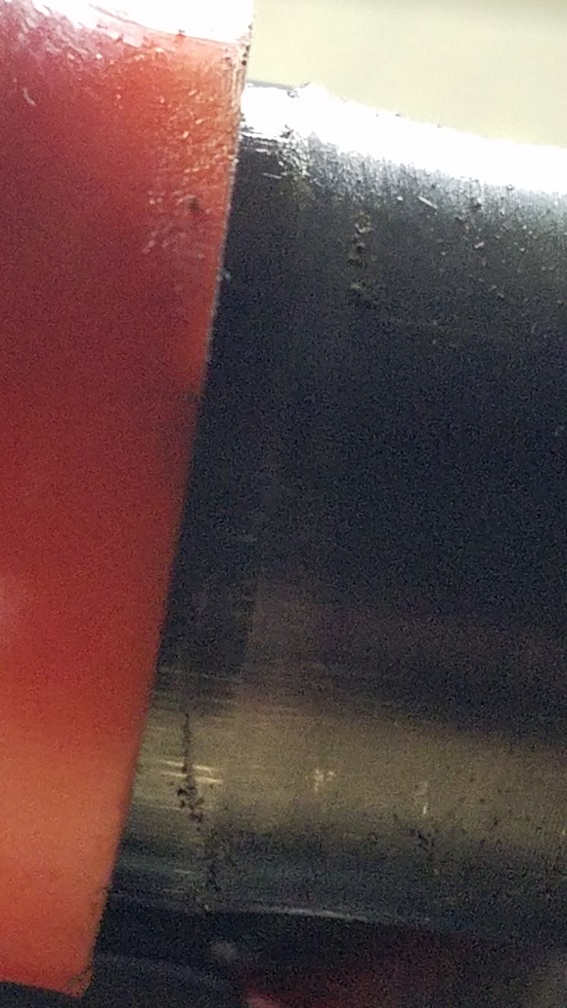
Broken axle means time to upgrade!
Posted: May 29, 2022 Filed under: Travel | Tags: broken, cadillac, repair Leave a commentHere’s a story of the details of what happened on the run to check the Long Lake Trail last week.
On the way out, I heard a strange sound coming from the front driver’s side tire. Before attempting the lower hairpin on Cadillac Hill, I stopped to check it out.
It was pretty easy to find where the noise was coming from. This was taken at the staging area. When I first checked it, there was no scrapes on the yoke. It appears that the ears of the outer shaft broke first, as the u-joint is undamaged but missing both caps.
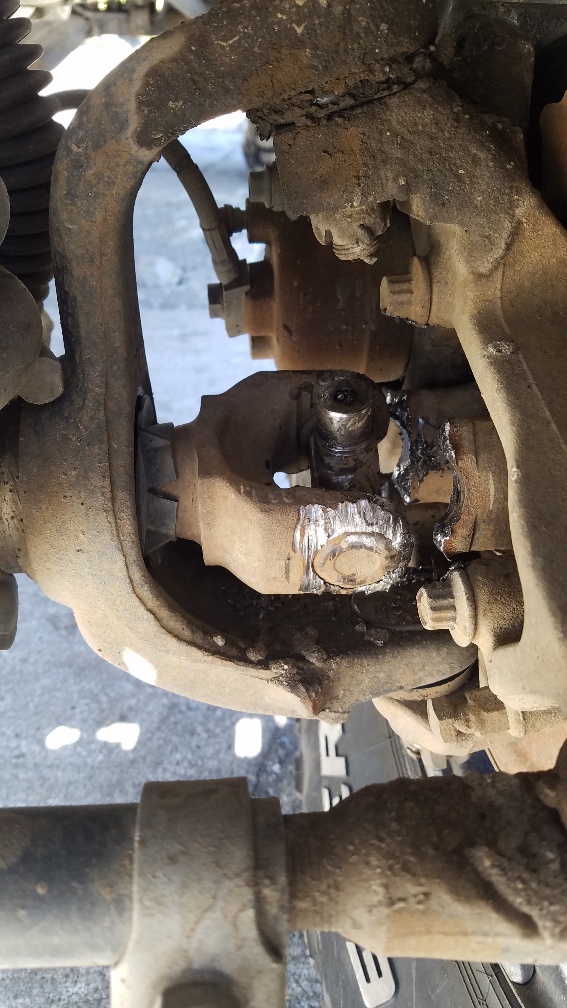
We figured it was easiest to just leave it as it was and just drive out. Luckily, with a Rubicon model TJ, I still had three-wheel drive with both lockers engaged.
As the broken ‘ears’ were slowly bent out, contact was made with the knuckle. Fortunately, the axles I was going to put in required just such an extra clearance.
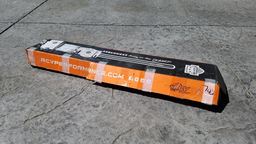
Enter RCV axles! If you’re going to upgrade, go all the way.
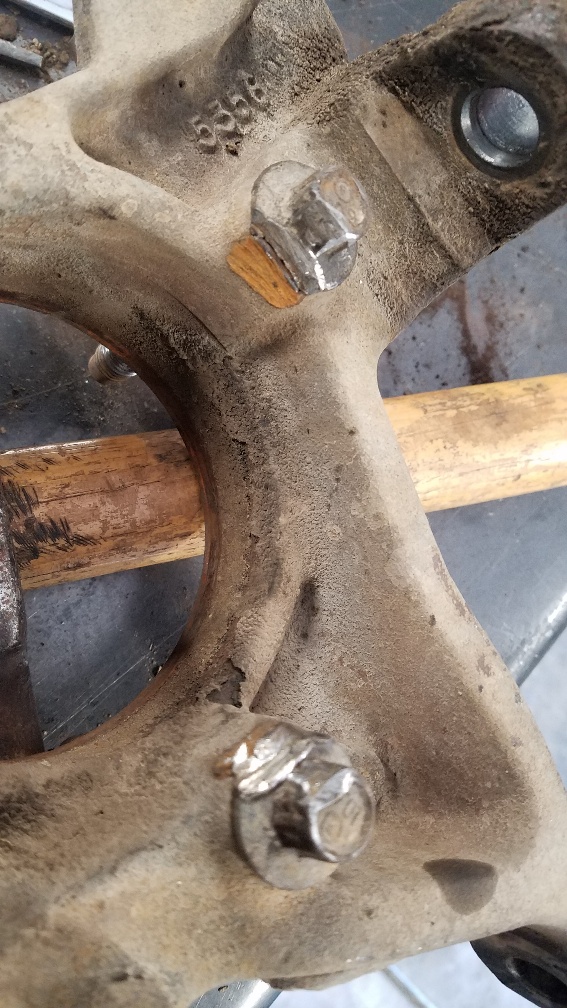
The driver’s side inner axle had been ‘hammered’ into the axle housing. It took a few hits with a big hammer to free the axle. The proper move might have been to remove the outer shaft as soon as possible.
A 4 1/2″ angle grinder was used to clearance the knuckle for the boot of the new axle. They were then cleaned and painted.

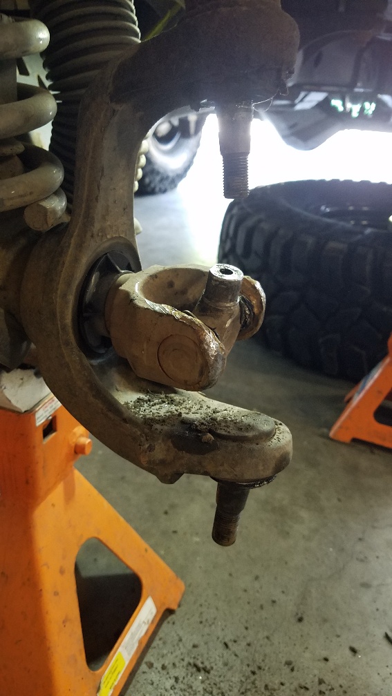
The new axles in place. Very distinguishable with the bright orange boot. This is a fully seated boot on. Easier said than done.

The manufacturer provided a sleeve to hold the boot as you slide the axle through it. But seating it properly was a pain; theirs is on the left side below with the hood. That was for before you installed the brake shield and unit bearing.
I built the one on the right to use after the unit bearing had been installed.

With a pair of pry bars, I was able to fully seat the boot. Or so I thought. I actually had to use the manufacturer’s piece and mine together to fully seat the boot. I’ll be making a thicker unit to carry with me in case I need to reseat the boot on the trail.

If you’re doing an RCV axle installation, make sure the boot is on far enough to see the edge of the boot seat surface.
As if a broken ear on the trail at the base of Cadillac Hill wasn’t enough, when I took apart the passenger’s side, I discovered that I had thrown a u-joint cap but the joint hadn’t come apart yet.

My axle was not the only issue. A fellow traveler lost all of his power steering fluid due to a fitting coming loose. That was an easy fix: tighten and refill. Between the six rigs we had what we needed.
I will admit that I had not loaded all of my trail boxes for this trip. I loaded more for clearing trees from the Long Lake Trail and possibly spending the night than I did for repairing a broken rig. The lesson is to bring everything you can on every trip.
.
Rubicon Ronin

