
Meeting/tour with the LTBMU
Posted: November 10, 2016 Filed under: Access, Maintenance, Travel | Tags: fire Leave a commentSo, yesterday (11/9/16) was a busy day.
I had a 30 minute meeting at 10am with the LTBMU to discuss updates to the new map for the staging area. I got out of that 30 minute meeting at 10:50am. Just enough time to make my 11am meeting with the new Lake Tahoe West Restoration Partnership.
Short story there, this is yet another group formed to ‘restore’ a part of our forest. I’m not yet sure who is funding this effort or why this section of forest was picked. But, Amy Granat of CORVA asked me to be a part of this discussion due to my local OHV knowledge. In order to get an interview with the group, I had to be ‘officially’ affiliated with some recognized group. So, CORVA made me a ‘Field Representative’:

While in the meeting with Lake Tahoe West, the LTBMU texted me to ask if I had time to meet at the Rubicon staging area to discuss ‘things’. Instead of driving over 50 and up 395 to get home, I went back up 89 to the staging area.
On the drive north, I took a few pictures of the recent Emerald Bay Fire. This is just south of Emerald Bay. The first shot is looking south. You can see the open areas near Camp Richardson in the background.

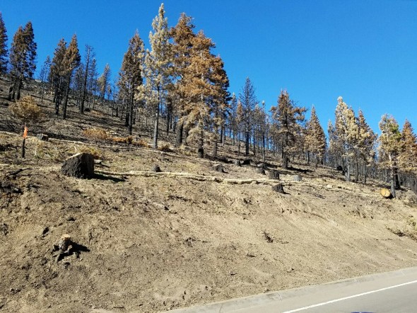
The Forest Service crews were out in strength dropping trees at the edge of the highway, putting down ground cloth and booms to prevent the coming storms from washing off the topsoil and then spraying with that green compound that promotes new growth.
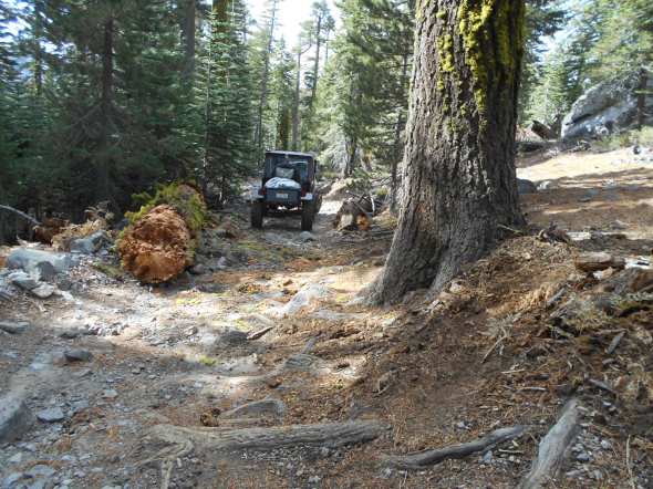
At the staging area, Mike, Jacob and I discussed the sign, the surface of the parking area, signs, overflow parking, etc.
Then Mike said he wanted to see Miller Lake and the turn to the Richardson Trail. Now you must take in to account what I’m driving. It’s my daily driver, a 2012 Chevy Colorado. Now it has the Z-71 package and a 2.5″ lift and 33″ tires. A vehicle quite capable of doing most of the trails in the area, but yesterday, it also had a small load of firewood in the bed and two kayaks strapped to the top.

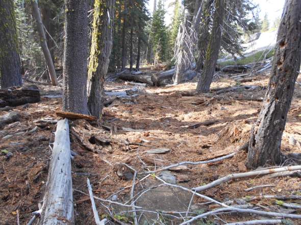
Up the trail we went. Then Mike asked Jacob if he wanted drive the loop and go out Blackwood Canyon. The Forest Service was driving a stock Ford Ranger, no lift. There were a few puddles that had already lapped at the door of the Ranger. I couldn’t let them drive the loop alone, so with kayaks and firewood in tow, we headed to Barker Pass.
At least I had my winter stuff in the truck: shovel, come-along, tow straps, etc.
Mike was riding with me so I could bend his ear on anything that came to mind. He glanced over and asked if we had enough fuel to make it out. I explained that I normally top off my tank before venturing off-road but I didn’t have that expectation today. I said we’d be fine, but was a little worried when the ‘low fuel’ light came on.
That situation was a great opportunity to discuss the new “No Outlet Nov 6th – June 16th” sign to prevent people from getting stuck at a gate on their way out Blackwood Canyon and not being able to turn around and drive all the way back out to the Rubicon staging area be it fuel, vehicle damage, darkness, injury, etc.
We finished our day at the Middle Fork staging area discussing signage.
I ended up putting 17.4 gallons of fuel in my 19.5 gallon tank. We had plenty, but it was a long day as I didn’t get home until 5:20pm.
Rubicon Ronin
Snow in the mountains!
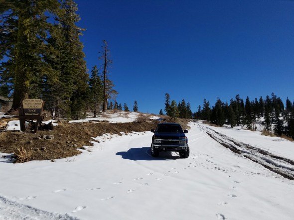
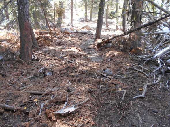
Posted: November 3, 2016 Filed under: Access, Travel Leave a commentI checked out Barker Pass Road today. Since the road is scheduled to close (past the river) on November 1st, I was surprised to find the gate open. I started to the summit wondering how much snow there would be.
Half way up the mountain, I wondered if I’d make the summit. The ruts continued to grow until they were about 10″ deep.
It was like driving that ride at Disneyland with the curb in the middle. You were sort-of steering but it was not easy to drive off the road.

Well, I did make it to the summit and on the west side the snow had melted quite a bit. There were two other rigs up there. One couple skiing. I wish I had a second vehicle around and time to play. The side trails must have been really fun. Tie to get out the snowmobile!
The Middle Fork trail is open until the 15th. That would probably unpassable going up (too steep), and very tricky with the narrow trail and steep drop-offs, going down.
While out and about, I checked the Rubicon trailhead. Not much snow left but I’m sure as you gain altitude on the trail, the snow depth will grow as well.
Travel prepared. Figure everything will go wrong and pack to spend the night: food, shelter, warm clothes, water, space heater. sleeping bag, HAM RADIO, etc.

“Turn Around, don’t Go Around”
Posted: October 24, 2016 Filed under: Uncategorized Leave a commentSo, “Turn Around, don’t Go Around” has been the unofficial motto of this website. This weekend it came in to play twice. The first time, we didn’t go around, we cleared the trail. The second time we turned around.
Traveling down to Rubicon Springs Saturday morning (10-22-16), we came up to a rather large tree across the trail.
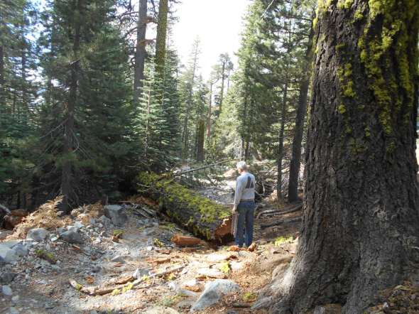
In two different places, people who didn’t know any better or were to lazy or unequipped to deal with the situation, drove around the tree.

Unfortunately, I didn’t take the time to photo our method but a single winch line and a snatch block was all that was needed to clear the trail.


The tree will need a more permanent solution but I think it will wait until spring.

The rocks should hold the tree off the trail until we can cut it up and remove it completely from the trail.
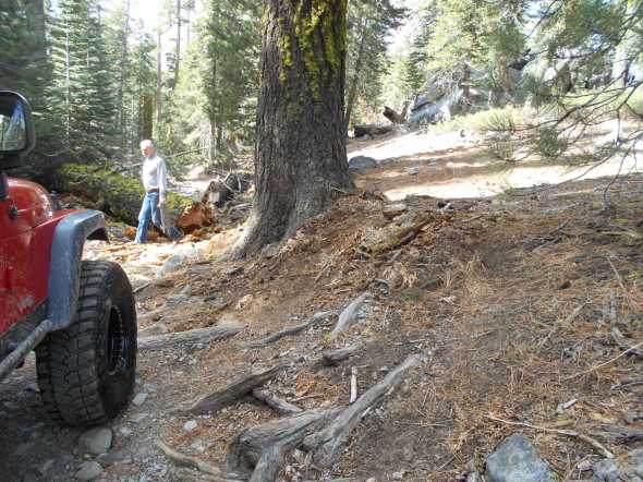
At the bottom of Cadillac Hill, we turned on to the Long Lake Trail to check conditions. We didn’t get too far and found trees down. We cleared a few and kept going. Then we got to this:

At this point stopped driving and walked in to the campground along the river to check things out.
We had a chainsaw if we really had to go down this trail but we were planning on camping in the springs anyway.
The Hi-Lo’s will ad this to our schedule and try to get the trail cleared as soon as possible.
Did I mention the Springs…

After probably ten inches of rain in the previous week, there were puddles everywhere. Also evidence of the river rising out of the banks and moving toilets, wood and misc. debris down stream.
We camped along the slabs.
Rubicon Ronin
New trailer hitch
Posted: October 17, 2016 Filed under: Travel | Tags: maintenance, recovery, trailer Leave a commentFor those of you following my website, you know of my issues with off-road hitches. Here is a link to the two previous postings:
https://theotherrubicon.wordpress.com/?s=hitch
The “Lock N Roll” Great Lake Forge hitch didn’t seem to like the tight turns and difficult terrain of the Rubicon Trail. I bent two of them! Though I must admit, I did roll the trailer twice with that hitch.
So I’ve moved on to the Max Coupler hitch by Kilby Enterprises:

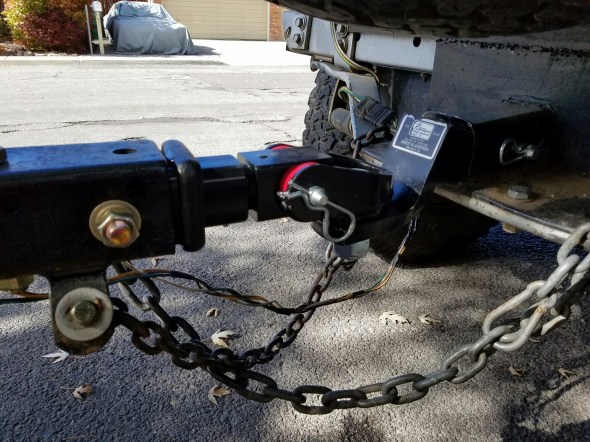
After unbolting the previous hitch, I inserted a 18″ ‘receiver’ tube and drilled two vertical 5/8″ holes to mount the receiver tube to the trailer. A third horizontal hole mounts the unit in the receiver tube and trailer.
FYI, the wheeled trailer stand gets removed before hitting the trail.
I lucked out and the first hitch configuration I used to mount the unit to the Jeep got the trailer pretty level. If I hadn’t bent the stock Jeep ball hitch, I think this would be dead level.
Unfortunately, I don’t think I’ll get a chance to test the new set-up this season. Although I will be out on the trail, I don’t think I’ll be needing the trailer. I’ll post up again after I test it out.
Rubicon Ronin
Tahoe side points of interest
Posted: October 16, 2016 Filed under: Travel | Tags: education, Placer, Rubicon Leave a commentBoth Placer County and the Lake Tahoe Basin Management Unit (LTBMU) are looking for a list of Tahoe side points of interest along the east half of the trail within Placer County.
The LTBMU is putting together a new map for the staging area and would like to add these points. I think Placer wants them for a map for their website.
Here is what I have so far, please let me know what I’ve missed or if you call any of these by a different name:
Highway 89
Entrance @ Residential
Quad Rental Parking
FS 14N34: Noonchester Mine Road
Overflow/size Parking
Bridge (Car Wash)
Staging Area
Gatekeeper (sort-of)
FS 14N40: Buck Lake Trail
TNF/LTBMU boundary
FS 3102-26 (turnout)
Adopt-A-Campsite: Elevated
Adopt-A-Campsite: Snag
FS 3102-24 (Campsites across from Miller Lake)
Boat Ramp
FS 3102-22 (Campsite on west end of Miller)
14N39: Richardson Lake Trail
The Pond
FS 03-04-12-05: Ellis Peak Trail
FS 03-04: road to Barker Pass
Pacific Crest Trail
Bottom Dollar Hole
Potato Patch
Old Water Hole (filled)
FS 16E76: Barker Meadow OHV Trail (lower)
Hummer Bend
Helicopter Flat / Birthday Cake (the mountain in the distance)
FS 16E77: Bear Camp
FS 16E78: Observation Point
Trees Section
Creek Crossing (with log water bar)
Upper Hairpin
Morris Rock (The Steps)
The Notch (Squeeze Rock)
U-Rock (Formally V-Rock)
The Cadillac (over the side of the trail)
S-Turn
Lower Hairpin
Roots & Rocks Section
Granite Outcropping – alternate route
The Driveway
The Graves
FS 16E12: Long Lake Trail
Miller Creek
County Line

