
It Snowed, a LOT!
Posted: March 5, 2024 Filed under: Access | Tags: berm, plowing, snow, winter Leave a commentThe drive from Tahoe City to Tahoma on Highway 89 was a little sketchy but at least there was two-way traffic. Once on the side streets of Tahoma, it was a one lane road.

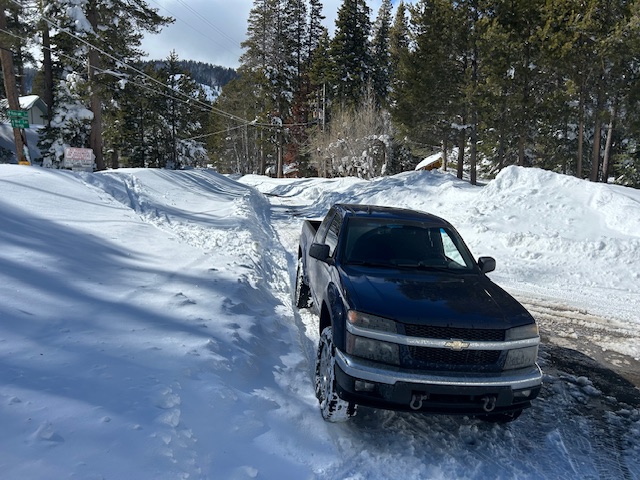
The trailhead didn’t disappoint. With 89 inches of snow falling during the last storm, there was quite a berm at the entrance. The rotary plow had not come through the neighborhood at all. Not only was the berm taller than my truck, once it gets plowed, it will be MUCH taller than my truck.

This shows the width of the berm and that Placer County is still plowing the entrance straight across the entrance.
The locals are up and over the berm, on foot, and skis. It will be some time before a wheeled vehicle makes access.
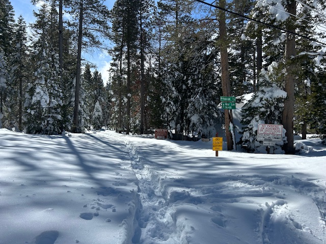
This is the road off 89 on my way out. That’s 89 in the distance. At least this road was down to the pavement.

I’m not sure when the next storm is coming in but there will be another one.
If you go out, be prepared to spend the night: shelter, food, water, warm clothing, means for keeping warm. Ham radios work all year ’round. Don’t travel alone. Tell someone where you’re going and when you’ll be back.
.
Rubicon Ronin
Rubicon Staging Area Work Has Started
Posted: October 2, 2020 Filed under: Access, Maintenance, Travel | Tags: berm, kiosk, parking, paving, snow, staging Leave a commentThere was meeting yesterday with El Dorado County, Placer County Lake Tahoe Basin Management Unit and CA State Parks. Also in attendance were representatives from the Rubicon Trail Foundation and of course me.
The plan was to meet at the Placer County building in Tahoe City and talk about the winter snow berm, possible winter parking and work to be done at the staging area. Well, the invite list got so large that the meeting was moved to the Tahoma staging area. Outside and Covid-19 safe.
I was surprised to see that work had started in the area. Let’s start with the new kiosk. It will be going in just to the left of the current kiosk. The new kiosk will be twice as large as the current sign with the new FS map 4’x8′! You can barely make out the four steel stakes that will outline the concrete footprint of the kiosk base.

Paving the staging area has been in the works for more than five years but until now, always as a plan. Yesterday, it was clear that the FS is going forward with the paving. The trees within the staging area have been cut down and will be available for firewood some time soon.

The trees along the road, between the staging area and the road will remain. The removal of the trees will allow for more parking and make parking and paving a whole lot easier. At this time, there are no plans to paint any parking stripes. The plan is to let the users figure it out.
Right now, the dates for actual paving will be as early as possible next summer (2021). This will depend on the winter snowfall and air temperatures. Access to the Rubicon through the Tahoma staging area will be closed for a few days due to paving. Access to the Rubicon will be available through Blackwood Canyon.

The parking area might expand a small bit as a result of this work. The Rubicon itself will be paved all the way up to where the current kiosk stands. So that ever present hole at the end of the pavement will be gone. Other improvements will include picnic tables in the grassy area behind the bathrooms. El Dorado County and their grant work is also a part of the funding for the paving.
Winter parking was briefly discussed as a future project with no current plans to move it forward. The idea floated was to pave the quad rental parking area and to plow the trail in to that point. Again, there are no plans to make this happen, it was just talked about.
The real reason for the meeting was to discuss the snow berm that builds up at the entrance due to plowing the residential neighborhood. I have personally been at this fight for more than five years, closer to six.
Here is a map of the intersection in question. I left several of these with Peter Kraatz of Placer County.
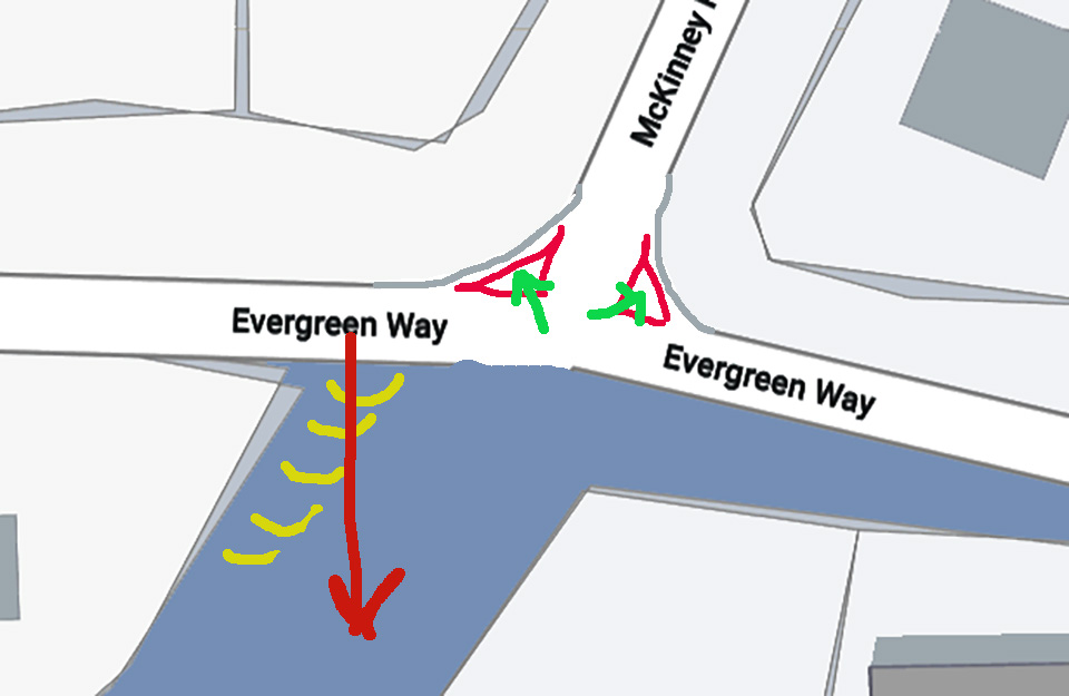
This is how the intersection typically looks in the winter. The “Rubicon” is the fourth leg of the intersection not really show here as most people find it this way in winter.
Explaining my markings: the yellow curves show the ditch to the north of the Rubicon trail, the red arrow shows how users accessed the trail last winter as Placer plow crews pushed snow from the intersection to the southwest corner of Evergreen and the Rubicon, the red triangles represents the snow in the intersection, the green arrows are where I’m suggesting Placer puts that snow.
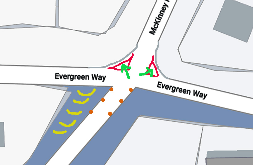
The next image actually shows the Rubicon. The orange dots are suggested snow stakes so the users know the best direction to access the Rubicon to stay on the pavement and out of the ditch.
We are not asking Placer to plow the Rubicon Trail nor are we asking for parking along Evergreen. We just don’t want Placer piling snow on the west side that blocks access to the Rubicon Trail.
No firm dates for the next step. Placer County is working on a public meeting to discuss the issue. Hopefully in November.
.
Rubicon Ronin

