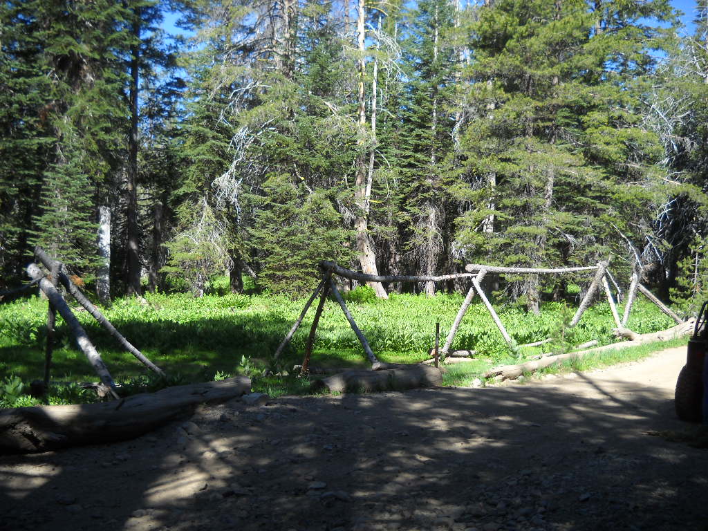
Blocking a bypass (again)

Last fall, I took the time to block two illegal single track bypasses along the Rubicon Trail. These bypasses were created by motorcycles and later enlarged by quads. They were “needed” because the Rubicon Trail had standing water on it. That should be read as tongue in cheek because these bypasses were not needed. All OHV users should stay on the trail. My line, that I should turn in to bumper stickers and t-shirts is “Turn around, don’t go around”.

Here are pictures from one of the two worked last fall.  Before…

DSCN0328


After…

DSCN0345


I even took the time to wire tie most of the logs together to really let those who wanted to dismantle it know that they were going to have to work at it a if they wanted to break the law again.

Well, this spring, the logs were moved by those who didn’t have the skill to ride/drive through the water. I had put up signs asking that those who wanted to help maintain the Rubicon Trail for ALL types of users should contact FOTR. I never heard that anyone wanted to help do that work.

So, round two.

Only one of the two bypasses was blocked off this time around because only one water hole still had water. I’m hoping Placer County will come through with the grant and fix the trail so this is no longer an issue. But until then…

Before…

DSCN0558 DSCN0560


After… 

DSCN0563 DSCN0564 DSCN0565 DSCN0567


This time, some of the logs were drilled and anchored to the ground or each other with rebar.

Again, signs were placed stating to contact FOTR in order to help maintain the trail.

I’m all for ALL types of users on the Rubicon Trail and the surrounding trails but everyone needs to follow the rules. During discussions about users driving off trail, the idea of having Placer County close the trail if they can’t keep users on the trail was brought up. It was not seriously considered but it was discussed.

We need to educate each other about proper etiquette and the consequences of breaking the rules. Please take the time to politely educate anyone you witness breaking the rules.


Turn around, don’t go around.


ENF starts fire restrictions

Starting June 14th, Eldorado National Forest is restricting fires:

Link to FS page (same as below)

Fire Restrictions

Pursuant to 16 USC 551 and 36 CFR 261.50(a) and (b), and to provide for public safety and protect natural resources, the following acts are prohibited within the Eldorado National Forest and the Moore Creek Fire Restriction Area on the Stanislaus National Forest, as shown on Exhibit B and described in Exhibit C.. This Order is effective from June 14, 2014 through the end of the 2014 fire season.
1. Building, maintaining, attending or using a fire, campfire, or stove fire, except within the stoves and fire rings provided in the Developed Recreation Sites, as shown on Exhibit A. 36CFR 261.52(a).
2. Smoking, except within an enclosed vehicle or building, a Developed Recreation Site shown on Exhibit A or while stopped in an area at least three feet in diameter that is barren or cleared of all flammable material. 36 CFR 261.52(d).
3. Welding, or operating an acetylene or other torch with an open flame. 36 CFR 261.52(i).
4. Operating or using any internal or external combustion engine without a spark arresting device properly installed and maintained in effective working order. 36 CFR 261.52(j).

Pursuant to 36 CFR 261.50(e), the following persons are exempt from this Order:
1. Persons with a permit from the Forest Service specifically authorizing the otherwise prohibited act or omission.
2. Persons with a Special Use Permit from the Forest Service for a recreation residence in a recreation residence tract, may build, maintain, attend or use an elevated charcoal grill, propane grill or campfire at their recreation residence, provided that they have a valid California Campfire Permit and comply with the terms of the permit.
3. Persons with a valid California Campfire permit are NOT exempt from the prohibitions above. However, persons with a valid California Campfire permits may use a portable stove or lantern that uses gas, kerosene, jellied petroleum or pressurized liquid fuel.

These prohibitions are in addition to the general prohibitions in 36 CFR Part 261, Subpart A.

A violation of these prohibitions is punishable by a fine of not more than $ 5,000 for an individual or $ 10,000 for an organization, or imprisonment for not more than six months, or both. 16 USC 551 and 18 USC 3559, 3571, and 3581.

Executed in Placerville, California, this 11 day of June 2014.

_______________________
LAURENCE CRABTREE
Forest Supervisor
Eldorado National Forest

Executed in Placerville, California, this 12 day of June 2014.


TNF sets fire restrictions

Starting today, June 1st, 2014, fire restrictions are in place on the Tahoe National Forest.

Forest order 17-14-03

Please be extremely careful out there this year. We’ve had three weak winters and the forest are very dry.  Let’s no lose what we love to enjoy by being careless with fire.


Tahoe NF Motor Vehicle Use Map Released!

The Tahoe National Forest (TNF) finally released the latest Motor Vehicle Use Map (MVUM). The forest had been without one for years. It had released and then retracted one previously.

TNF MVUM

There are ten maps for the four different districts within the Tahoe National Forest. The Rubicon Trail is documented on the Truckee District -south map. Hard copies of these maps are available for free at any of the TNF offices.

The Rubicon is listed as 16N75. Although the Rubicon is listed on and has been given a Forest Service (FS) number, it is still a county right of way. The FS gave it a number as the trail needed to be listed to have the rest of the area trails make sense.

New in this version of the MVUM, Observation Point (16E78) is officially recognized by the FS as being a 163 foot long ‘trail’. Previously undocumented, the turn out has always been allowed by the FS.

Also new are four camp sites:

3013-026 is an elevated area from the Rubicon before the old water hole. The FS documented this ‘road’ as 64 feet long.

3013-24 is at the east end of Miller Lake just past the old water hole. The FS documented this ‘road’ as 29 feet long.

3013-22 is at the west end of Miller Lake and is truly lake front. The FS documented this ‘road’ as 62 feet. It’s more of a turn out.

16E77 is just east of Observation. It’s know as Bear Camp and in the early spring is under six inches of water. It’s 50 feet long or deep, depending on how the FS measured it. It is documented as a ‘trail’.

And for the first new OHV trail in a long time on the TNF, the Long Lake Trail, previously known as TKS-11, is now officially 16E12.


I want to thank the TNF for getting this out to the public. It took a lot of hard work to get this right. The last map was actually printed but because there were so many flaws the forest decided not to release it and to make the needed corrections. It’s worth the wait.


Now get out there and try a trail you’ve never been on before!


Updating Wikipedia

I’ve been asked why I chose such a dividing title for my website. I don’t think it’s as dividing as it is accurate. So much is written and talked about on the El Dorado side of the trail that I thought the Placer side deserved a little attention.  In a perfect world, there would be one website with everything anyone would ever need to know about the Rubicon Trail. I started that site years ago for RTF but after handing it off and after RTF changed the format, interest waned and the site is sort of stale.

Today, I came across the perfect example of what I claim above.  I visited the Wikipedia page for the Rubicon Trail. There is an introductory sentence then a description about the Rubicon. This is how it read, before I changed it a little bit:


“The maintained portion of the route is called the Wentworth Springs Road; it begins in Georgetown, California, a hamlet in California’s Gold Country. The road continues from its intersection with State Route 193 towards Wentworth Springs, where the trailhead for the unmaintained portion of the route exists adjacent to Loon Lake. The trail portion of the route is about 12 miles (19 km) long and passes in part through the El Dorado National Forest.”


It seems normal and accurate enough, right? What about after it passes through Eldorado National Forest? So, I added a little bit and left the incorrect spelling of El Dorado National Forest. The County is El Dorado while the Forest is Eldorado.

The new paragraph, underlined words added:


“The western maintained portion of the route is called the Wentworth Springs Road; it begins in Georgetown, California, a hamlet in California’s Gold Country. The road continues from its intersection with State Route 193 towards Wentworth Springs, where the trailhead for the unmaintained portion of the route exists adjacent to Loon Lake. The trail portion of the route is about 12 miles (19 km) long and passes in part through the El Dorado National Forest as well as the Tahoe National Forest and the Lake Tahoe Basin Management Unit. The eastern maintained portion is known as McKinney Rubicon Springs Road.”


And now the red headed step child side of the trail has been represented.