
Wind drops trees
Posted: October 16, 2014 Filed under: Uncategorized Leave a commentThis week brought the beginning of fall. The trees are changing colors, the temperatures are dropping and the bikini Jeep tops are being swapped out for a full soft top or hard top. Also, a huge wind storm blew across California and in to the Sierra Nevada mountain range.
I was headed to the Rubicon trail and knew it would be windy, so I made sure I had my chainsaw, saw bag and that it was running well before I left the house. I am sure glad I did.
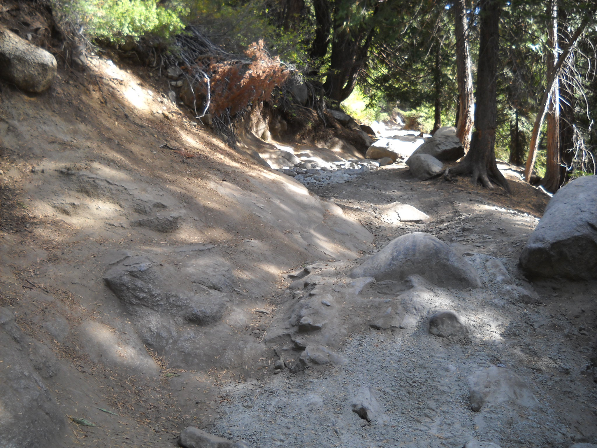
Around 11am, the wind hit. I was out the Long Lake Trail. The great thing the wind brings is a bug free afternoon. Going up Cadillac was a breeze (sorry, easy pun).
I was well on my way home when I came across a down tree west of Miller Lake. It wasn’t blocking the whole trail but I felt large or at least tall rigs might have an issue with it, so I broke out the saw. It didn’t take much but cleared the snag from over the trail and the debris from the trail itself.


Please remember to always wear proper protection when running a saw: hearing, glasses, gloves, long pants, sturdy closed toe shoes. To take it all the way, you should also wear a helmet and chaps.
Feeling like I’d done something positive for the community, I went on my way. It was getting late and it had been a long day. I left the staging area just before 9am and it was now after three in the afternoon. I had a meeting in Reno at 6pm and it was going to be close.
Then I came across another down tree truly blocking the entire trail.

This one was between water bar 14 and 13. It was much larger than the first one, and blocking a wider section of the trail. Out came the saw again. And I cut it in to many manageable size pieces.
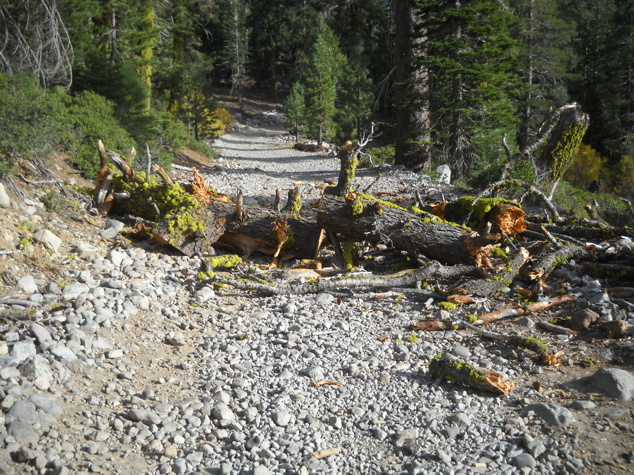
The nice thing about a tree that has fallen across an OHV trail is that the tree is usually rotten or extremely dry making it very easy to cut. I pushed the section of tree to the sides of the trail. It may be necessary to further remove the sections from the trail but there is a sizable path between the sections now.

Always go prepared. If you come across an issue like this and you can’t clear the trail, turn around, don’t go around.
.
Jeepers Jamboree works Cadillac Hill
Posted: October 16, 2014 Filed under: Maintenance | Tags: maintenance, Placer, Rubicon Leave a commentLast weekend, Jeepers Jamboree folks organized, staffed and completed a maintenance effort at the Hairpin Turn on Cadillac Hill. Just after the apex of the turn, there is a climb that has a granite slab that slopes down from left to right but on the right side there is a rock that sticks up.
Over the years, the approach to this obstacle has eroded away deepening the channel down the middle of the trail and more so on the right side. The last time I was on the trail, prior to the fix, the right side was under-cut to the point my 35″ tire wouldn’t climb it. I had to back off and throw a few rocks in the hole in order to make it up that section.
Well all has changed. I don’t know how many bags of concrete were used but the channel and the hole were filled in with concrete and rock. Over this winter and after a few dozen rigs, it will get dirty and most travelers won’t even know it’s there. Points to Placer County and the OHV grant for supplying the concrete.
This is one of many spots on Cadillac Hill that is being held together with concrete. There is concrete at V-Rock, the Notch, Morris Rock and many point in between. It is needed to maintain the trail and to keep the trail safe for travelers.
Thank you Jeepers jamboree for a job well done!

LTBMU, ENF & TNF lift fire restrictions
Posted: October 4, 2014 Filed under: Access | Tags: ENF, fire, LTBMU, TNF Leave a comment
The last of the trio of Rubicon forests has lifted fire restrictions. The ENF lifted restrictions as of 10-8-14.
http://www.fs.usda.gov/detail/eldorado/news-events/?cid=STELPRD3819658
Starting 9-30-14, the Tahoe National Forest has lifted fire restrictions for the season.
http://www.fs.usda.gov/detail/tahoe/news-events/?cid=STELPRD3818599
Starting 10-3-14, the Lake Tahoe Basin Management Unit has lifted fire restrictions for the season.
http://www.fs.usda.gov/detail/ltbmu/news-events/?cid=STELPRD3818996
Although I feel this is too early, fires are now allowed with the proper fire permit. Please take the time to make sure the fire is completely out. This means OUT, not just no flames. The fire pit should be cold enough to run your hands through the coals. I usually pour two five gallon buckets of water on the coals and stir as I go.
Several unattended fires have been reported over the past summer along the Rubicon. Luckily, none of them turn in to major wild fires. The only major fire was arson. We did have a few lighting started fires. The one instance I heard of where a camp fire became a wild fire was in Desolation Wilderness, and you know that wasn’t the fault of a wheeler.
Please be safe and help protect our forests.
King Fire Closures
Posted: September 25, 2014 Filed under: Uncategorized Leave a commentUPDATE: As of 9-30-14, the Edorado National Forest has reopened the Rubicon Trail.
10-3-14, Both Placer County and the LTBMU have removed closure notices from their websites.
Due to the King Fire burning that started outside Pollock Pines, the Rubicon Trail is currently closed on both the Eldorado National Forest and within the Lake Tahoe Basin Management unit:
It’s hard to find within the Eldorado Forest closure order but the Rubicon is not only closed but there is a mandatory evacuation of the Rubicon Trail within the Eldorado National Forest.
http://inciweb.nwcg.gov/state/5/
This site will give you links to fire all over the state of California including the King Fire.
New Trailhead Sign
Posted: September 21, 2014 Filed under: Uncategorized Leave a commentSome time ago, I emailed RTF and let them know the RTF map displayed at the Tahoma staging area was getting a little faded and reminded them it had been shot earlier. I ask for a new sign to keep the sign board looking professional.
What showed up last Wednesday was not what I expected. The new sign (I can’t call it a map) is a satellite image with the Rubicon Trail displayed in black and multiple ‘points of interest’ marked on the map.
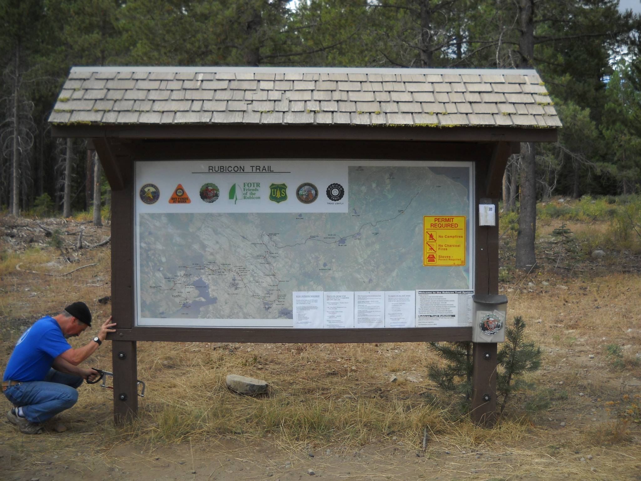
At first glance you might be impressed. Upon a closer look, you realize there are no side trails off the Rubicon anywhere on the Tahoe side. There are no topographical lines. There is no scale to estimate travel distances. Being a new sign, you might expect the recently approved camp sites to be listed, nope.
There are many ‘points of interest’ listed within El Doardo County but only a few within Placer County. Some places not listed: Potato Patch, Mud Hole, Driveway, Notch, Roots, S-Turn, etc.
There are points on the sign that are listed as trails. The first is the Barker Meadow OHV Route. The sign doesn’t snow where it goes only the intersection with the Rubicon Trail. The point depicting the Long Lake Trail at the base of Cadillac Hill is labeled as the Lost Trail. Again, just a dot no line show the length or direction.
The sign was already installed when another volunteer and I went to the staging area to re-install information on ham radio frequencies, agency contact information, GPS locations and how to get in touch with someone in order to volunteer. That was the first time I had seen the new sign. And I was extremely upset.
For years I’ve been pushing for better recognition of the Tahoe side of the Rubicon Trail. This website is just the latest. One of my bigger complaints awhile back was Friends of the Rubicon declaring that summer ‘The Tahoe Side Year’ and then never offering the volunteers any Tahoe side trail maintenance projects.
The removal of the RTF map, with side trails, togographical lines, scale, etc. and the placement of the new sign is a disservice to users of the staging area. The information displayed should educate the users to all types of recreation and all OHV routes in the area. The new sign does not do this.
Not being one to hold my tongue, I fired off a letter to ALL those I thought might have been involved with the development of this sign:
Map at Tahoma staging area
September 19, 2014
Involved individuals and agency representatives,
It was recently reported that the map at the Tahoma staging area was faded, shot up and in need of replacement. The wheels of government turned and this week a new sign appeared at the staging area. This new sign is one of the worst OHV trail maps I’ve ever encountered.
Over the years, we have all referred to this staging area as “The Rubicon Trail Staging Area on the Tahoe side” or something to that effect, when in reality it is a USFS OHV Staging Area serving much more than just the Rubicon Trail. This staging area serves street legal four wheel drives, side-by-sides, quads and motorcycles, yes, single track. It also provides a jumping off point for hikers, fishermen and mountain bikers. I’ve even see horses leaving the staging area.
This new sign does not include a single side trail within the Lake Tahoe Basin Management Unit (LTBMU) or the Tahoe National Forest (TNF). There are no hiking trails shown. There are no campsites documented. There are no rules posted with this sign. There is no scale for the users to try and gauge how far they might be able to travel in one day.
There are a dozen or more ‘points of interest’ labeled within El Dorado County: Little Sluice, FOTR Bridge, Whale Bone, etc. But there are a scant few on the Placer side of the map. Where are Bottom Dollar Hole, Potato Patch, The Mud Hole (now filled), Helicopter Flat, The Notch, S-turn, Hairpin Turn, Roots Section and The Driveway?
The newly added Long Lake Trail in the TNF is incorrectly labeled as the Lost Trail. It’s just a dot on the map, not the actual trail. The Barker Meadow OHV Trail is another dot, no trail. The Noonchester Mine Road, The Richardson Lake Trail, The Ellis Peak/Lake Trail, The Buck Lake Trail are all not listed.
When I first saw the sign I planned on taking it down. But I soon learned it was mounted to a ¼” thick piece of wood and I had no way to transport it. Later next week, I will remove the new sign and replace the faded, shot-up Rubicon Trail Foundation (RTF) map that was originally there as the old sign, even in its battered state, is ten times better than the new sign. I will return the new sign to who I believe is the rightful owner, Placer County.
Those included in this email need to fix this issue. A map needs to be produced that include all types of trails as far north as the Middle Fork Trail in Blackwood Canyon. It should include every OHV opportunity the map covers. It needs scale, contact information, GPS locations, and so much more.I would like to see a round table discussion, with everyone in this email thread, to decide what needs to be included and how to best present it on a map for the users to be able to understand and enjoy their public lands.
Doug Barr
It would be safe to say I pissed off a few folks. So be it. I spoke the truth. The new sign is inferior to the old, faded, shot up, RTF map.
Do to this letter and several other instances of me speaking openly, honestly, with passion and without sugar coating, I have been relived of my duties as the liaison between the Friends of the Rubicon and the Tahoe National Forest. Again, so be it.
I’m betting my golf game will improve.
Although I have a few topics already outlined to write about, I think I’ll take a little break from this website.
But stay tuned.

