
Tahoma Kiosk Installed
Posted: October 20, 2020 Filed under: Access, Travel | Tags: kiosk, map, staging Leave a comment
Today I drove up to the staging area just to see the progress on the new kiosk. And it’s almost done!
It is not what I expected but it’s a HUGE improvement over the old kiosk.

The asphalt coming next summer will run right up to the concrete base.

The new kiosk is much bigger than the old one, which I’m trying to move to the Middle Fork trailhead in Blackwood Canyon. Not only does it have twice the space for posting information, it has the same amount of space on the backside…
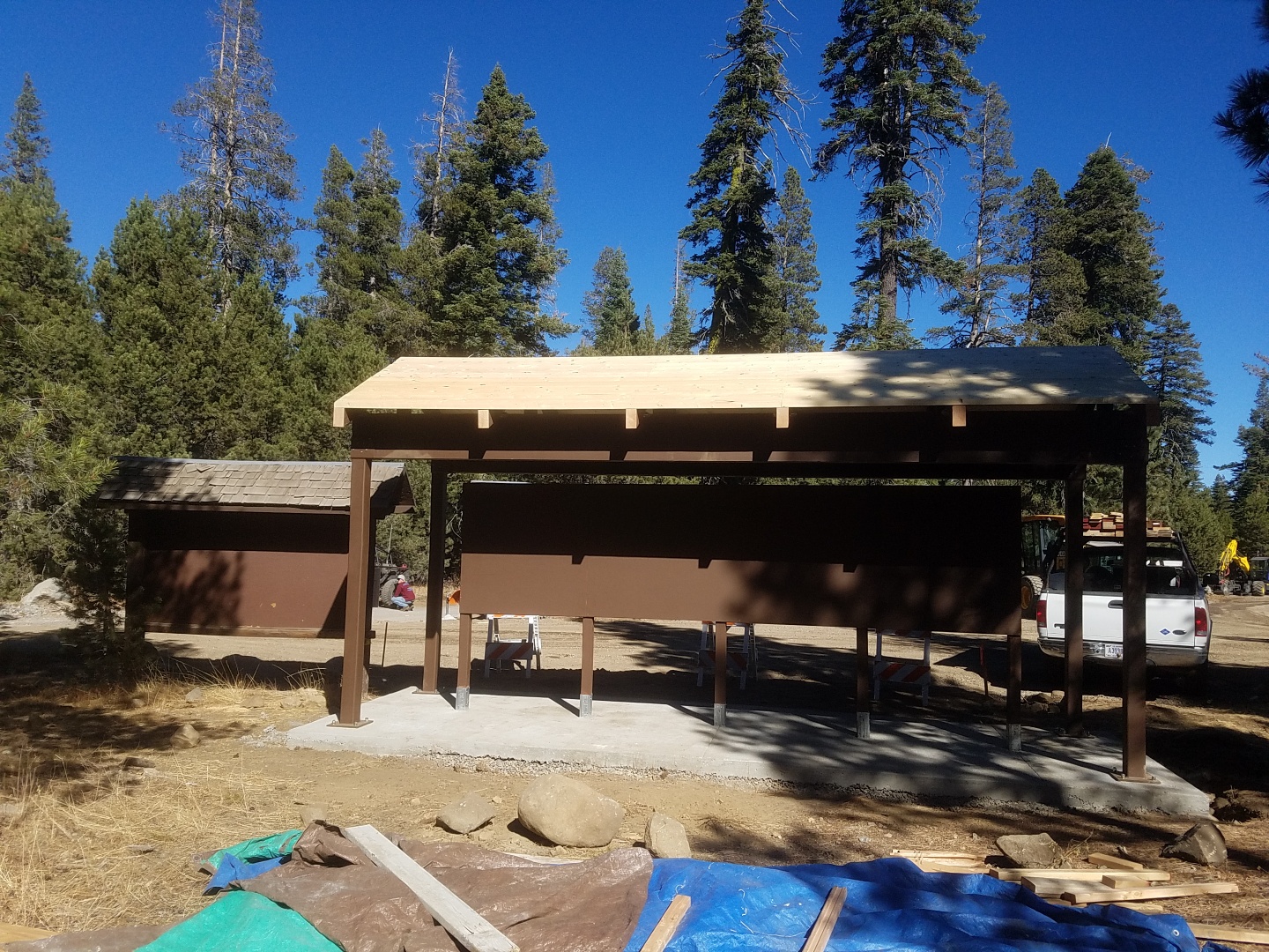
The Lake Tahoe Basin Management Unit has also developed a new map which will be posted 4’x8′. No need to get out the glasses to figure out where you’d like to go.
.
Rubicon Ronin
Long Lake Trailhead Sign
Posted: June 29, 2020 Filed under: Access, Maintenance, Travel | Tags: Hi-Lo's, long lake, map, signage, TNF Leave a commentSeveral years ago, the Lake Tahoe Hi-Lo’s installed a trailhead sign at the entrance to the Long Lake Trail (16E12). It’s the left turn just before the graves on the Rubicon Trail.

Well, over those years the sign was a little neglected. That changed this past weekend at the Hi-Lo’s returned and installed new posts for the sign and updated the information on the sign.
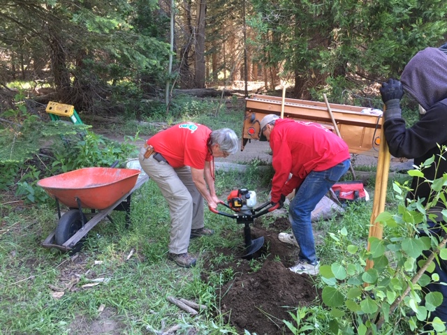
It was truly a team effort. I provided the signage, Michael brought a power auger, Gary brought hand and power tools (and the trailer to haul all this stuff), Scot provided the cement, Carlos was do everything man of the day. Kade served as the finisher making sure everything was squared away at the end.

Hopefully, fewer people will take a wrong turn there as they head to Cadillac Hill and Lake Tahoe as probably six rigs did while we were there! I do want to add a small “Dead End” sign.
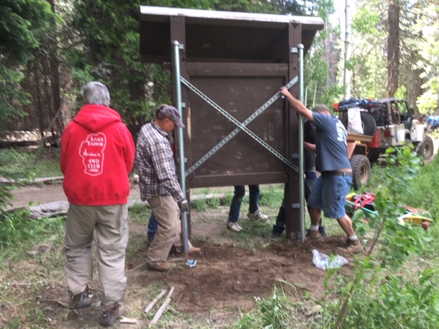
The post and sign are not going anywhere with the concrete, pipe and brackets used!
It needs paint and a piece of plexiglass but it looks great.
I personally want to thank everyone that had a hand in this project. It was really a team effort and with so many people stepping up, it didn’t take a whole lot of effort. The hard part was getting our act together before hitting the trail to make sure we had everything.
.
Rubicon Ronin
New map addition for flier
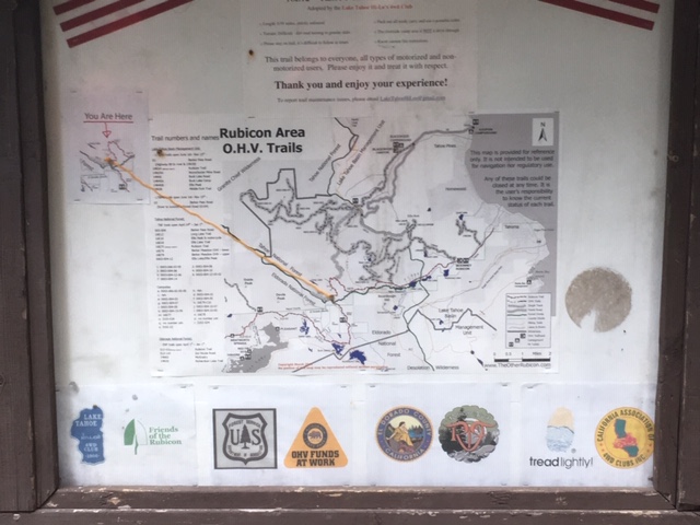
Posted: June 8, 2018 Filed under: Access, Travel | Tags: camping, education, map Leave a commentThe 2018 Rubicon Area OHV Trails map/flier is hot off the press.
Hopefully, by Saturday afternoon, I’ll get them at the Rubicon trailhead in Tahoma. Once the Middle Fork Trail opens, I’ll post them there as well. The LTBMU is on board and even the TNF has allowed me to put up my map and fliers at the Barker Pass intersection.
So, not a lot of changes but one very important change. I’ve added a better representation of the Rubicon Trail Foundation (RTF) property and the trail to access the property. If you remember, there was a land swap done to allow vehicle access to the RTF property from the Rubicon. So, the RTF property is no longer the traditional rectangle of a half section of land.

Please remember that the RTF property is private property. It must be open for you to drive there. The plan is for the property to be open every weekend this summer but not mid-week.
The trail on the map is an approximation. It should not be used for navigation but rather for the general location of the trail. Please stay on the trail and Tread Lightly!
RTF plans to build a caretaker cabin on the property this summer. That will allow the property to be open all summer in 2019.
For more information on the RTF property, I suggest visiting the RTF website:
www.RubiconTrailFoundation.com
If you have suggestions for future versions of this map or the flier please contact me:
TheOtherRubicon@charter.net
Rubicon Ronin

