
Long Lake Trailhead Sign
Posted: June 29, 2020 Filed under: Access, Maintenance, Travel | Tags: Hi-Lo's, long lake, map, signage, TNF Leave a commentSeveral years ago, the Lake Tahoe Hi-Lo’s installed a trailhead sign at the entrance to the Long Lake Trail (16E12). It’s the left turn just before the graves on the Rubicon Trail.

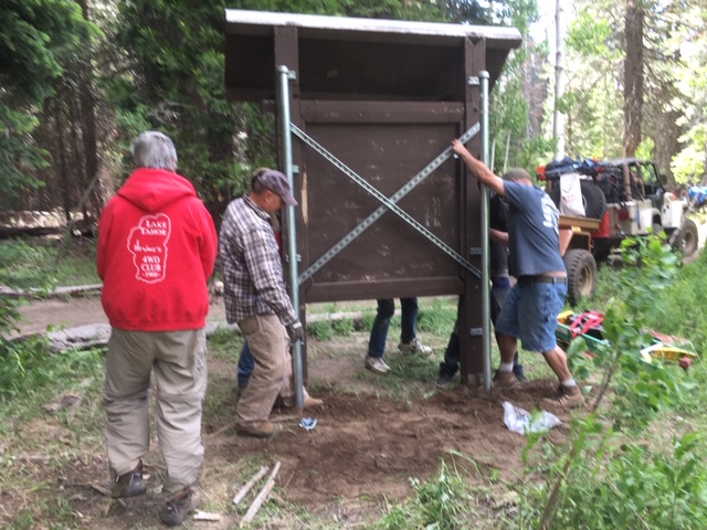
Well, over those years the sign was a little neglected. That changed this past weekend at the Hi-Lo’s returned and installed new posts for the sign and updated the information on the sign.
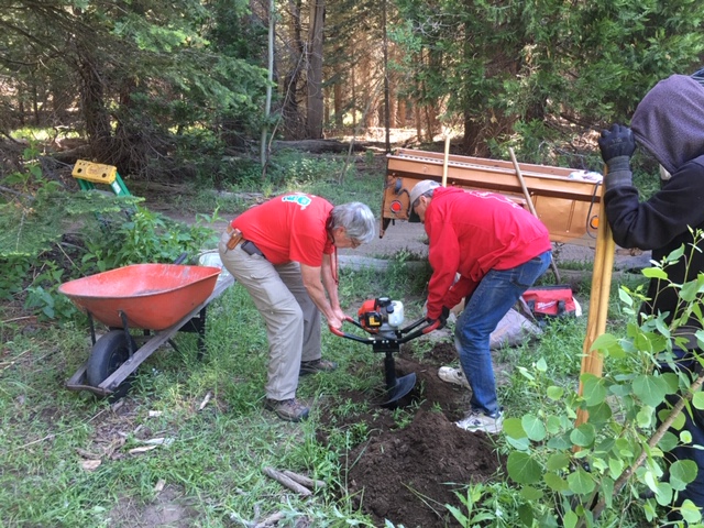
It was truly a team effort. I provided the signage, Michael brought a power auger, Gary brought hand and power tools (and the trailer to haul all this stuff), Scot provided the cement, Carlos was do everything man of the day. Kade served as the finisher making sure everything was squared away at the end.

Hopefully, fewer people will take a wrong turn there as they head to Cadillac Hill and Lake Tahoe as probably six rigs did while we were there! I do want to add a small “Dead End” sign.
The post and sign are not going anywhere with the concrete, pipe and brackets used!
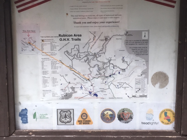
It needs paint and a piece of plexiglass but it looks great.
I personally want to thank everyone that had a hand in this project. It was really a team effort and with so many people stepping up, it didn’t take a whole lot of effort. The hard part was getting our act together before hitting the trail to make sure we had everything.
.
Rubicon Ronin
Long Lake campsite
Posted: September 7, 2016 Filed under: Access, Maintenance | Tags: access, education, Hi-Lo's, Long Lake Trail, maintenance, TNF Leave a commentThe Lake Tahoe Hi-Lo’s have adopted the Long Lake Trail (16E12) since it was officially recognized by the USFS in 2014. Since 2011, we have been working with the USFS by bringing FS personnel out there and doing trail maintenance to the point they would accept it, including removing an outhouse and hardening a seasonal creek crossing.
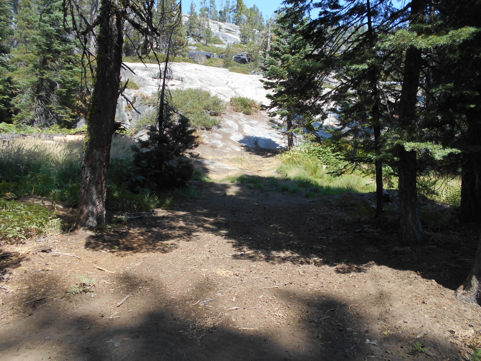
There is a campsite off the trail about halfway down the trail. It is a sharp U-turn to the left and brings you right down along the Rubicon River. This campsite is great for larger groups and offers a quiet change of pace from Rubicon Springs.
Here is the hard left U-turn:

Looking down the campsite, the Rubicon River on the right:

Unfortunately, some people have tried to make this a drive through site by driving off trail, down a granite slab and through a marsh (in spring time). The Forest Service will not allow this ‘through route’.
This was one of three turns off the Long Lake Trail in to the back of the campsite:
This is the ‘backdoor’ in the campsite that in the spring time is a wet muddy marsh:
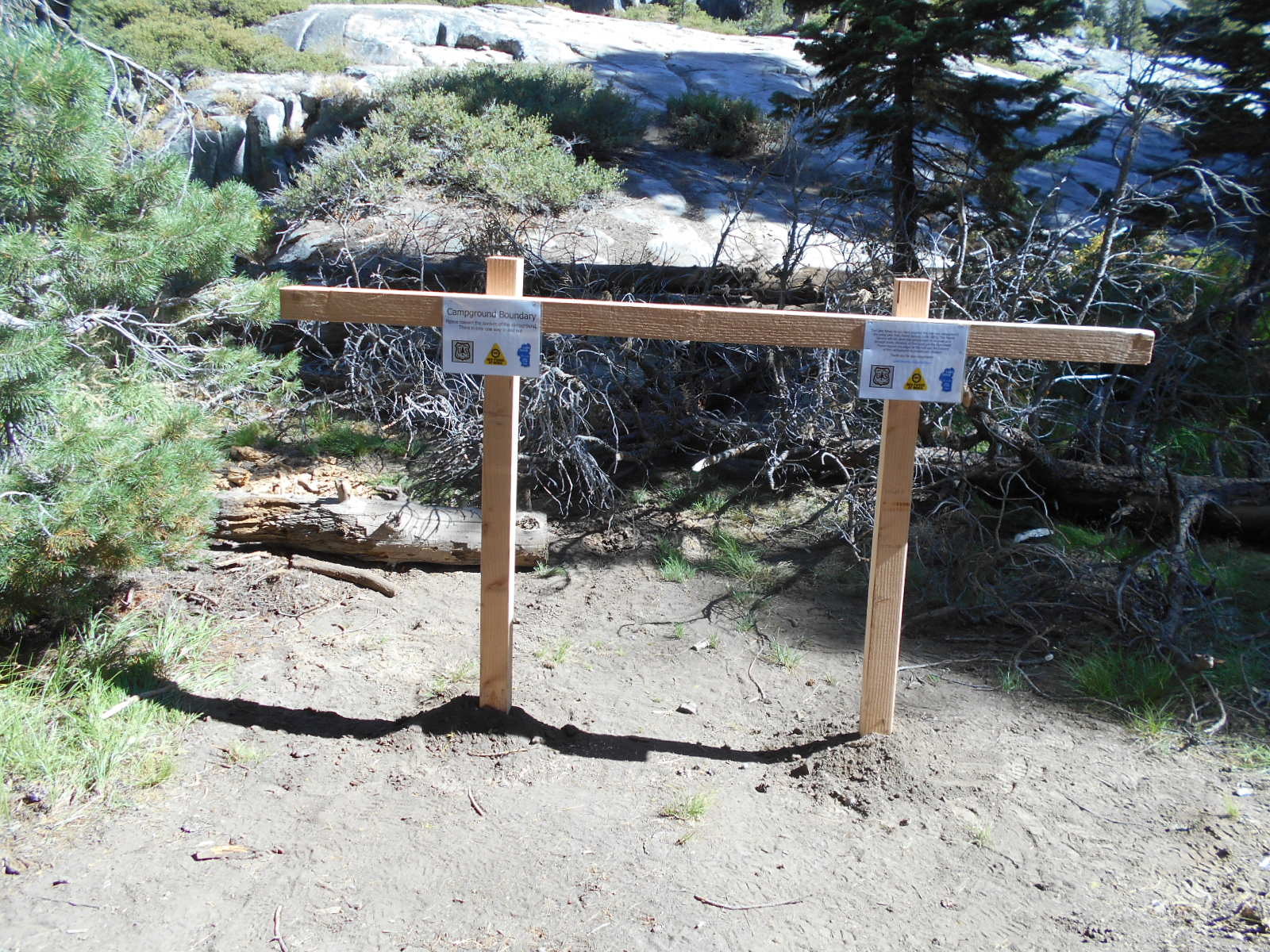
The Hi-Lo’s have now blocked the ‘through route’ several times. This time we added 4×4 posts with signage explaining the campsite boundary and the possible consequences if the off trail driving continues.
There is now no mistaking this as a possible route to the campsite:

Within the campsite, we added some educational materials to the 4×4 posts:
Having the campsite as a one way in/out is much nicer than a through route. I wouldn’t want anyone driving through my camp at 1am trying to figure out where the actual trail runs.
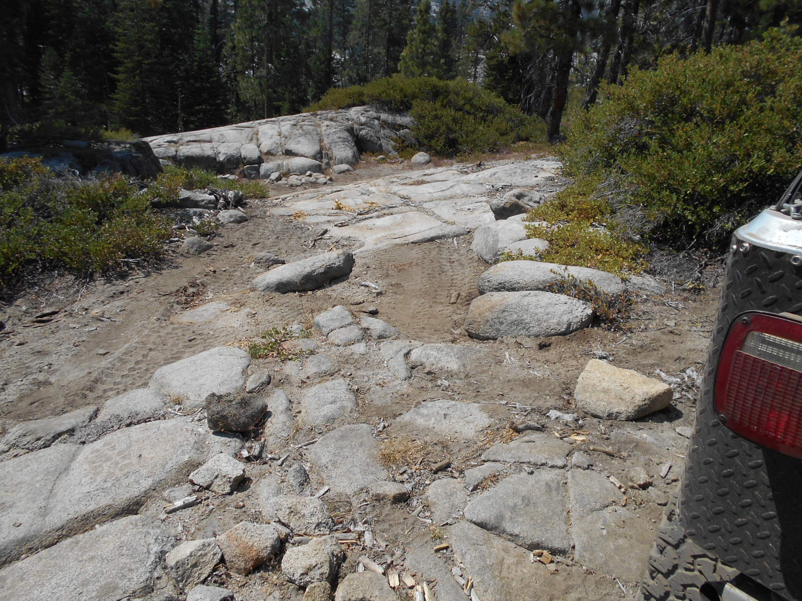
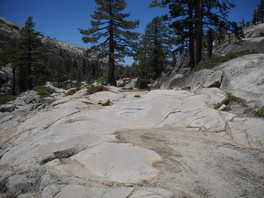
Also, please note that the trail is only 0.91 miles long. It ends before a 90 degree right turn, an extremely steep climb up a granite slab and another 90 degree left turn; which leads to a boulders strewn seasonal waterfall.
Driving past the recognized end of the trail could result in fines.

Although I do not promote or support driving off trail, the Long Lake Trail is not well defined past the campsite. There are easy routes and extreme routes to get to the end of the trail.

When driving the Long Lake Trail at night, please be extremely cautious. There are steep drops all along the trail. It’s best to have someone walk the trail in front of your rig in order to prevent accidents.
Link to a Photo Journal of the Long Lake Trail.
All I ask is that you always Tread Lightly!
- Don’t drive over bushes
- Don’t leave oil spills on the granite
- Use a WAG bag when camping on granite slabs
- Don’t spin your tires so much you leave marks on the granite
- Leave a clean camp
- Make sure your fire is out cold (Have fires only when restrictions lifted)
- Keep the music down after 10pm
- Pack-it-in, pack-it-out
- Respect other campers
This trail has something for everyone. As long as we respect the trail and each other, we will all be able to enjoy it.
Rubicon Ronin
The LTBMU fails to get any OHV funds
Posted: June 9, 2016 Filed under: Access, Maintenance, Travel | Tags: access, FOTR, grant, Hi-Lo's, LTBMU, maintenance, OHV grant, OHV State Parks, Placer, TNF Leave a commentThis OHV season, the CA State Parks OHV Division made available almost $11 million dollars for OHV issues, projects, maintenance, law enforcement, education, etc.
The Lake Tahoe Basin Management Unit (LTBMU) failed to obtain a single penny of it. In comparison, the Eldorado National Forest (ENF) received $438k and the Tahoe National Forest (TNF) received $650k.
There is a 30 day grace period for the agency requesting funds to ask that their grant be reviewed and rescored but don’t hold your breath. This is the second straight year the grant writers and administrators at the LTBMU have fallen short. I think it’s safe to say the LTBMU needs a new grant writing staff.
Here’s the problem, even though the LTBMU didn’t receive CA State Parks grant funding, they are still required to manage OHV on their forest. It’s just going to be that much more difficult without specific funding for OHV.
I’m using this lack of funding problem to push the LTBMU to reinstate the Adopt-A-Trail program they dumped two years ago.
If you or your club, group, business or organization would like to adopt an OHV trail within the LTBMU, email them, call them, hound them, do not take no for an answer, Right now I only know of the Twin peaks Trail in South Lake Tahoe, the Buck Lake Trail off the Rubicon and the Middle Fork Trail up Blackwood Canyon (just north of the Rubicon) that historically have been adopted.
That list doesn’t include the pre-Placer County Rubicon when the Lake Tahoe Hi-Lo’s had the entire east side of the trail adopted. For adopting a section of the Placer side of the Rubicon Trail, contact the Rubicon Trail Foundation.
Here is a list of OHV trails within the basin from the LTBMU website. Not all trails are listed. Check the Motor Vehicle Use Map (MVUM) for more trails.
Lake Tahoe – East Shore
- Genoa Peak Road 14N32
- Kingsbury Stinger 18E39.3
- Logan House 14N33
Lake Tahoe – North Shore
- Kings Beach 18E18
- Mt Watson 73E
Lake Tahoe – South Lake Tahoe
- Corral Trail 18E14
- Hellhouse Road 12N01D
- High Meadows Trail 18E33A
- Power Line Road 12N08
- Sand Pit 12N08
- Sawmill Pond 12N30
- Twin Peaks 12n30
Lake Tahoe – West Shore
- Buck Lake Road – 14N40
- McKinney / Rubicon Trailhead
- Noonchester 14N34A
Please step up, adopt a trail, push the LTBMU to work with the users!
Long Lake Trail opens Saturday
Posted: April 21, 2015 Filed under: Access, Maintenance | Tags: access, Hi-Lo's, Long Lake Trail, TNF Leave a commentThe Tahoe National Forest (TNF) Motor Vehicle Use Map (MVUM) has the Long Lake Trail opening on Saturday the 24th. Last weekend, the Lake Tahoe Hi-Lo’s got permission to run the trail early to make sure it was open and safe for the general public.
We drove down Saturday morning without a major issue. One guy heard a rattle and after borrowing a 1/2″ coarse thread nut from a fellow traveler, we were on our way.The run in was a very casual pace. It was nice not to be rushing to get somewhere for a specific time.
The Long Lake Trail only had one tree down but it was rather large:

The nice part was that it was rotten and cut very easily. It actually broke apart as we tried to winch it out of the trail.

We made camp at the campsite along the trail. Other than the two geese that woke everyone up at 6:30am, it was an uneventful stay at the camp. Rain clouds threatened over night. but it never rained.
The drive out was slow and steady. No break downs but some challenging spots going up Cadillac Hill. It seems the rocks continue to “grow” out of the mountain. Future maintenance will be needed to prevent further erosion along Cadillac Hill.
So, the Long Lake Trail is open for business. Please stay on the trail and remember that it ends 0.91 miles in. Also, the campsite is one way in and one way out. Please do not attempt to make it a drive through. Any off trail driving/riding could get the trail closed.
If you come across any issues with the trail or have any questions about the Long Lake Trail, please email me or the Lake Tahoe Hi-Lo’s at LakeTahoeHiLos@Gmail.com.
Enjoy
The season begins
Posted: April 20, 2015 Filed under: Uncategorized | Tags: access, Hi-Lo's, Long Lake Trail Leave a commentLast week I checked out the Rubicon for the first time this season. There was evidence of trees that had fallen across the trail but had been cleared, but no snow to speak of.
That was a little different on the Richardson Lake Trail, 14N39. This trail opened on April 1st. That is earlier than most side trails along the Rubicon. My plan was to drive the trail up to the gate at the Pacific Crest Trail (PCT) and clear any trees across the trail.
Along the way, I came across a few snow drifts on the trail, mostly on the northern aspect of the hill. Some had tracks of previous travelers but the last few did not. It’s a cool feeling knowing you are the first person of the season to run the trail. As long as I was breaking trail going uphill, I felt I was okay. Although alone, I had a winch, gravity and all my other recovery tools if I didn’t make the climb.
When I crested the climb and came across another snow drift in front of me going downhill. It was time to turn around.

This drift was no larger than any of the others I had already driven through that day but it was downhill. If I got stuck, I’d have to winch against gravity or further down the hill. If I had another vehicle with me, I would have driven it for sure. Maybe next time.
The snow is melting fast. I suspect most of the snow in that picture is now gone.
The Hi-Lo’s drove down to the Long Lake Trail on Saturday to open the trail for next weekend. There was one HUGE tree across the trail but it’s been moved. That trail opens to the public on April 24th. I’ll post a detailed report when I get some pictures from my fellow Hi-Lo’s. Enjoy!

