
Tree Elves
Posted: April 16, 2015 Filed under: Maintenance | Tags: maintenance, Rubicon Leave a commentI ran the Rubicon out to the intersection of forest road 03-04 on Monday. There wasn’t must in the way of snow on the trail but there was plenty of evidence of ‘Tree Elves’ working the night.

Even with the mild winter, several trees had blown over across the trail. These are just a few photos. This is good evidence to support the motto, go prepared. Late winter and early spring travels should dictate bringing a chainsaw and all of the safety gear that your should be wearing.

More than once, over the years, I’ve found myself cutting a log out of the trail on the way OUT! It’s easy to turn around on the way in if you encounter the trail blocked but what do you do on the way out? If you are prepared, you either cut or drag the tree out of the way.
Open house report
Posted: April 3, 2015 Filed under: Access, Maintenance | Tags: OHV grant, Rubicon, Twin Peaks Leave a commentYesterday afternoon, the Lake Tahoe Basin Management Unit (LTBMU) held an OHV open house from 4-7pm at their headquarters in South Lake Tahoe. Almost any OHV topic was fair game. There were about 18 users in attendance; 3-4 4wd clubs, a motorcycle club, interested citizens and an OHV business owner. Most people stayed for the whole three hour event. A few left and a few more showed up.
Overall, the event went well and most everyone got their questions answered and everyone gave comment and suggestion to the LTBMU. My thanks to the LTBMU for setting this up.
The LTBMU had people from the recreation department and the engineering department. They are transitioning and/or splitting OHV management from recreation to engineering. I’m not really sure they have a complete management plan for OHV.
There were also LEOs from the LTBMU and Ca State Parks. Ca State Parks had another representative who oversees the grant implementation for the LTBMU and other grants in the area. Unfortunately, they left before the end of the event. A few questions came up just for them.
The grant was discussed and the LTBMU stated that it wanted to focus its attention on finishing a project at Corral riding area started years ago. Many were concerned there was no money for 4wd trails, only motorcycle/ATV trails. The LTBMU claimed that they didn’t want to submit a scattered grant application that might look like they didn’t really have a plan. FYI, the LTBMU has already altered its grant application to ask for money to help open the pit toilets at OHV trailheads early, weather permitting.
There are new forms for “user agreements”. All the old ones have expired (and will expire every two years). Every member of the club or group needs to fill out the three page form that is mostly a series of questions where you need to just check a box. Finalizing shouldn’t take more than week. This has not been the case in the past. The users agreement allows the volunteer to work anywhere on the LTBMU, as long as it is a pre-approved project.
The LTBMU seems to have forgotten what an Adopt-A-Trail program is although they have currently have clubs with adoption paperwork. I’ll be pushing to get the LTBMU back on track with more AAT agreements.
The LTBMU has reaffirmed it will be revising their Motor Vehicle Use Map this fall. Although they claim it is only to make it more accurate, we need to stay on top of this so we don’t lose any trails. If fact, we should comment that certain trails need to be reopened. Start thinking what trails you might want reopened. (Duck Lake, North Fork, what else)
Also to be addressed with the MVUM revisions are opening dates. The LTBMU said they are open to using science and measurements on the trail in order to determine when they should open in place of a hard date. This could work to our advantage on snow years like the past three but it could work against us on the late/heavy winter years.
Off topic a little bit, the Sand Pits area in South Lake Tahoe near Twin peaks is set to open May 10th, two days early.
The Hum/Toy MVUM is missing the ‘middle section’. Not sure what that means but they are looking in to reprinting the maps.
Here’s a new twist, the LTBMU claims that the state has authority over the Rubicon Trail. The question of whether green sticker vehicles are legal on the “state route” came up. Technically, green stickers are not legal but have been allowed historically. We were assured that the enforcement will not change anytime in the near future.
It went well but in order to see if it really was a success we’ll have to wait and see if the LTBMU actually acts on any of our suggestions.
LTBMU to hold OHV open house
Posted: March 25, 2015 Filed under: Access, Maintenance | Tags: education, Hi-Lo's, maintenance, OHV grant, Rubicon, Twin Peaks Leave a commentChange of the hours: it should have read 4pm to 7pm!
This is a great opportunity to let the Lake Tahoe Basin Management Unit know how we feel about how they are managing our OHV trails. They will be open for discussion on the proposed grant, the management of Twin Peaks, the Rubicon Trail and all other OHV related subjects.
Let’s get a big turn out and let the Basin know we care about our OHV trails and how we would like to see them managed.
Forest Service to hold open house on off-highway vehicle use
South Lake Tahoe, Calif. – The U.S. Forest Service Lake Tahoe Basin Management Unit (LTBMU) will host an open house to discuss Off-Highway Vehicle (OHV) use on designated routes within the Lake Tahoe Basin on Thursday, April 2, 2015, from 4 to 7 p.m. at the Forest Supervisor’s office at 35 College Drive, South Lake Tahoe, CA 96150.
The open house provides an opportunity for the public to meet Forest Service OHV, engineering, trails and recreation staff and ask questions regarding the LTBMU Motor Vehicle Use Map (MVUM) and the California Off-Highway Motor Vehicle Recreational (OHMVR) Grant application. Local OHV club members will be on hand to discuss membership and volunteer opportunities sponsored by the Forest Service.
Contact Adrian Escobedo at aescobedo@fs.fed.us for reasonable accommodation access to the facility or proceedings.
For more information, contact Tim Merten at 530-543-2863 or tmerten@fs.fed.us.
###
The 2015 Cone Zone
Posted: March 15, 2015 Filed under: Access, Travel | Tags: El Dorado County, Placer, Rubicon Leave a commentYes, the orange blooms are already happening.
Road construction has started in the Lake Tahoe Basin. This is important enough that I may start a direct link to updated information on current construction project that could affect driving to and/or from the world Famous Rubicon Trail.
The website of the week: http://www.tahoeroads.com/
This website has all kinds of information on road construction around Tahoe. The easiest page to understand has pictures. So, rather than me ramble on with too many words, here are two pictures pages that says it all. The link is for the web page of the two images below.
http://www.tahoeroads.com/docs/files/File/TahoeBasinMap2014%20with%20logo.pdf:
![]()
![]()
The Sierra Sun is also reporting:
- Paving treatment on Highway 267, airport to the summit, May-Oct, 20 minute delays
- Paving treatment on 28, between Tahoe City and 267. Aug-Oct, 10 minute delays
- Bridge replacement on the road to Alpine Meadows at 89, May-Oct
- Highway 80 at the Donner Lake Interchange, May-July
- Highway 80 Boca to Floriston, May-Oct, 20 minute delays
Please check conditions before you travel. Add time to your trip as needed. Watch out for the workers.
Sign updated at staging area
Posted: January 29, 2015 Filed under: Access, Maintenance, Travel | Tags: education, El Dorado County, FOTR, Placer, RTF, Rubicon Leave a commentAs was the subject of the last “Photo of the month”, the sign at the McKinney-Rubicon Springs Road has been in the need of attention for some time.
Recently, some new material was installed along with a new piece of backing plywood and a new plexi-glass cover. Additionally, the broken map box was replaced and stocked with both the RTF Rubicon Trail map and the new Rubicon Area OHV Trails map and flier. The map was covered in my last post.
Here is the new signage in all it’s glory:
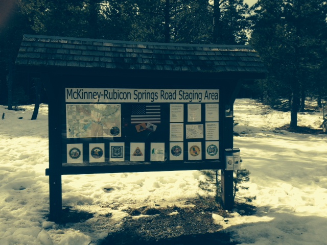
The RTF map is on the left.
The agencies involved with the trail are represented across the bottom: Placer County, El Dorado County, US Forest Service, CA State Parks OHV, Friends of the Rubicon, Rubicon Trail Foundation, CA Association of Four Wheel Drive Clubs, and the Blue Ribbon Coalition.
Towards the right is some educational information including ham radio frequencies, contact information for the agencies involved, how to volunteer, driving cautions and a copy of the new tri-MVUM map.
A close up of the new map box now housing the RTF Rubicon Trail map and the new tri-MVUM of Rubicon Area OHV trails:

This was a private effort. Hopefully, in the future, the agencies listed on the sign will get together with the users to decide what more signage and information is needed at the staging area and along the trail.
UPDATE 2-20-15:
The LTBMU visited the staging area and decided that the sign needed a few changes. Here is a photo of the current sign. I’m working on getting FOTR to join the party and hopefully, together, we can all get the information on the sign to reflect what the users need to travel safely and enjoy the area.
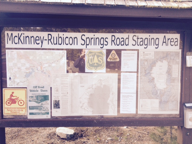
They added a full Motor Vehicle Use Map for North Tahoe and a snowmobile riding area map.

