
Traveling 03-04 early in the season
Posted: June 13, 2016 Filed under: Access, Maintenance | Tags: education, maintenance, Rubicon, TNF Leave a commentOn June 12th, at 7am, I headed out from the cabin in Carnelian Bay.
It’s not a long drive around the west side of the lake, only 15-20 minutes, but it was early and there was a chill. Trips like this are why I always have my old ski jacket with gloves and a hat in the Jeep.
Although I was looking forward to the drive time alone on the Rubicon and Forest Road 03-04, it was a work trip. As a volunteer with the Tahoe National Forest (TNF), I have agreed to place trail markers along the Rubicon and on the side trails in the area of Forest Road 03-04. That’s the road from the Rubicon, past Bear Lake that goes to Barker Pass at the top of Blackwood Canyon.
Today, I had a new mileage sign for the intersection of 03-04 and the Rubicon, a no outlet sign for 03-04 (did you read my last post?) and two 03 markers for Barker Pass Road where is meets 03-04.

Using a post hole digger in the Sierra Nevada mountains is not a straight forward process. I start one hole and got about 20″ down when I hit granite. I filled that one in and started another; only got ten inches down. Started a third; eight inches. I went back to the first hole and dug it out again. I figured I’d place a bunch o0f rock around the base to make up for the short hole. I was hoping to get them down at least 24 inches. That was the mileage sign.

I moved up 03-04 to start the “No Outlet 11/6 – 6/14”, the granite rock in the hole were smaller and the center of the hole kept shifting to get around the rocks. But the sign is up.

The day before, I had driven as far north as Bear Lake with the Tahoe Donner 4wdc. Today I would go further and by myself. Yes, I’m setting a bad example. But I had food, drink, shelter, fire starter stuff and a working ham radio.

Just north of Bear Lake, in a downhill section on a northern aspect, there was a sizable snowdrift. I went down it no problem but I knew I’d have trouble on the way out, even if I wasn’t pulling a trailer like I was that day.
I drained a few puddles along the way and had to cut two trees off the trail. The snow drifts were narrow and thus fun to pop over. There were a few longer ones that posed a small challenge but weren’t a problem.

The dirt at the intersection of 03-04 and 03 was very soft for digging but didn’t pack to well after placing the posts.
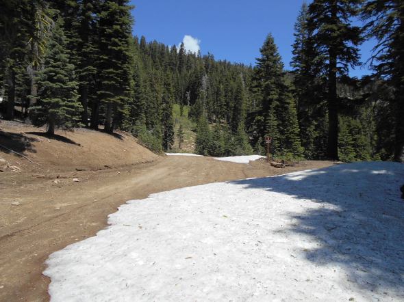
As predicted, on the way out, I had trouble in the large snow drift. Let the winching scenario begin. Of course I wanted to go straight up the trail, there are no trees right in the middle of the trail. So I winched a little to the right and then a little to the left and then once more to the right. But it worked.

The plan was to turn left on 03-04-12 and place some carsonite markers as well but there was a very large drift a short distance up that trail. Maybe in a week or two I’ll try again.
15N38 (Middle Fork) gate still closed!!!!
Posted: June 13, 2016 Filed under: Access | Tags: 15N38, access, LTBMU, Middle Fork Trail Leave a commentThe plan was to meet the Tahoe Donner 4wdc at the Rubicon staging area, run up the Rubicon to Forest Road 03-04 and head over to Blackwood canyon and come out the Middle Fork Trail, 15N38.
I had this feeling I needed to check the gate at the bottom of Blackwood Canyon at both Forest Road 03 and the Middle Fork Trail. The 03 road isn’t scheduled to open until June 15th, and they never OPEN roads early. The gate for 03 and the Middle Fork Trail are supposed to open June 1st. Well the main road was open but the Middle Fork Trail is still closed.
At the staging area, we ran in to another group who were planning the same route, Rubicon to 03-04- and out 15N38. I passed along the bad news. They took their six Unimogs and headed up the Richardson Lake Trail and made the summit. Some snow but enough dirt to maintain traction.
The Motor Vehicle Use Map (MVUM) posted at the Rubicon staging area has June 1st as the opening date for 15N38. The MVUM on the Lake Tahoe Basin Management Unit’s (LTBMU) website has June 1st as the opening date as well. Yet the gate isn’t open. I don’t know if the gate is open at the top.
The LTBMU needs to get on top of this and fast. How many other groups are going to head north from the Rubicon expecting to get out Blackwood Canyon and find closed gates?
Maybe some new guy at the LTBMU thinks it should open with the gate on 03 just past the river on June 15th. I’ll be contacting the LTBMU in the morning about this issue. Please feel free to join me in letting them know how you feel about them not opening our OHV trail in a timely fashion.(530) 543-2600
was headed to run around the Rubicon area on the 11th and
The LTBMU fails to get any OHV funds
Posted: June 9, 2016 Filed under: Access, Maintenance, Travel | Tags: access, FOTR, grant, Hi-Lo's, LTBMU, maintenance, OHV grant, OHV State Parks, Placer, TNF Leave a commentThis OHV season, the CA State Parks OHV Division made available almost $11 million dollars for OHV issues, projects, maintenance, law enforcement, education, etc.
The Lake Tahoe Basin Management Unit (LTBMU) failed to obtain a single penny of it. In comparison, the Eldorado National Forest (ENF) received $438k and the Tahoe National Forest (TNF) received $650k.
There is a 30 day grace period for the agency requesting funds to ask that their grant be reviewed and rescored but don’t hold your breath. This is the second straight year the grant writers and administrators at the LTBMU have fallen short. I think it’s safe to say the LTBMU needs a new grant writing staff.
Here’s the problem, even though the LTBMU didn’t receive CA State Parks grant funding, they are still required to manage OHV on their forest. It’s just going to be that much more difficult without specific funding for OHV.
I’m using this lack of funding problem to push the LTBMU to reinstate the Adopt-A-Trail program they dumped two years ago.
If you or your club, group, business or organization would like to adopt an OHV trail within the LTBMU, email them, call them, hound them, do not take no for an answer, Right now I only know of the Twin peaks Trail in South Lake Tahoe, the Buck Lake Trail off the Rubicon and the Middle Fork Trail up Blackwood Canyon (just north of the Rubicon) that historically have been adopted.
That list doesn’t include the pre-Placer County Rubicon when the Lake Tahoe Hi-Lo’s had the entire east side of the trail adopted. For adopting a section of the Placer side of the Rubicon Trail, contact the Rubicon Trail Foundation.
Here is a list of OHV trails within the basin from the LTBMU website. Not all trails are listed. Check the Motor Vehicle Use Map (MVUM) for more trails.
Lake Tahoe – East Shore
- Genoa Peak Road 14N32
- Kingsbury Stinger 18E39.3
- Logan House 14N33
Lake Tahoe – North Shore
- Kings Beach 18E18
- Mt Watson 73E
Lake Tahoe – South Lake Tahoe
- Corral Trail 18E14
- Hellhouse Road 12N01D
- High Meadows Trail 18E33A
- Power Line Road 12N08
- Sand Pit 12N08
- Sawmill Pond 12N30
- Twin Peaks 12n30
Lake Tahoe – West Shore
- Buck Lake Road – 14N40
- McKinney / Rubicon Trailhead
- Noonchester 14N34A
Please step up, adopt a trail, push the LTBMU to work with the users!
Signs, signs, everywhere signs
Posted: May 26, 2016 Filed under: Access, Travel Leave a commentLast week I sat down with Susanne Jensen of the Truckee Ranger District of the Tahoe National Forest (TNF) to talk OHV trails for the 2016 season.
She has procured two new signs for the Rubicon Trail area.
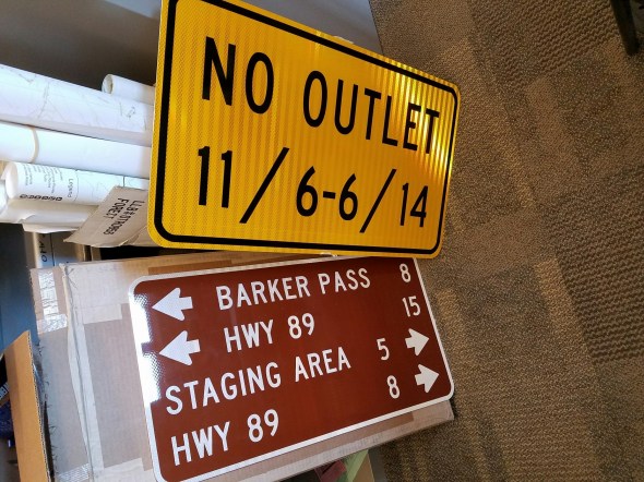
The first is for Forest Road 03-04 where it meets the Rubicon. As you come in from Tahoe, Forest Road 03-04 continues straight while the Rubicon is almost a 90 degree turn to the left. Forest Road 03-04 (if you continued straight) is closed seasonally from November 5th through June 14th. With this sign, we’re trying to prevent someone from thinking they can get out that way after November 5th and get lost, stuck or run out of fuel and not have anyone driving by regularly.
The second sign is for the same intersection but to be posted for those driving the Rubicon eastbound. This is a replacement sign as the original is long gone.
Susanne assured me there is funding to continue to install carsonite signs for all the side trails in the area. That will be one of my goals this season.
Headed out on the 1st and I’ll post up with a full report on the Rubicon and the side trails.
My Rubicon OHV season has started
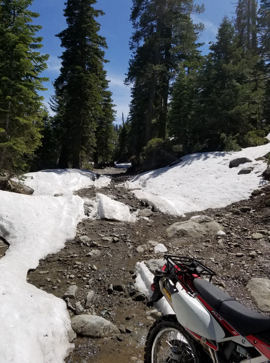
Posted: May 11, 2016 Filed under: Access, Travel Leave a commentThis afternoon I took out my, new to me, Kawasaki KLZ250s, dual sport on the Rubicon Trail.
Now, I have quite a bit of Jeep experience and quite a bit of mountain bike experience but not much experience at all on a dirt bike. So, of course I decide to take out the bike on the Rubicon in early Spring with snow drifts, running water and a deep water crossing. Yes, I got wet but I didn’t fall over.
No snow to the staging area. I drove the truck and had the KLX250 in the back. While there I filled the “Free Maps” box with my flier and the RTF flier. After heading out of the staging area there was snow on the sides of the trail at the first climb, stalled it. Once on the flats, past the Buck Lake Trail (still closed until June 1st), it was easy going but only got to second gear.
Lots of water on the trail. Most all of it is in sections that are rock covered so erosion is minimal. Please stay on the trail and drive slowly through water.

A snow drift here and there with Jeep ruts in them. Still the motorcycle didn’t have much traction on the packed down snow, go figure.
Then there was water bar #8. Let me explain. None of the water bars are actually water bars, they are rolling dips. Well, WB # 8 is actually an Arizona crossing. That is a concrete lined water crossing. There are many along the Rubicon and a few on the Richardson Lake Trail.
WB#8 at full flow, which it was, is 18” deep, or more! I knew this going in and just barreled through in second gear. It’s got to be ten feet across. I got wet. Not really bad, but wet.
Again, the trail is very wet but in this area rock covered. Further up the trail, around water bar #11, the snow covered the entire trail.

Hiking up a little bit, to see how far the snow covered the trail, I saw it was impassable for my skill level. The trail was covered, side to side for about 100 yards. Then no snow for about 40 yards, then twin ruts in the snow. I turned around.

Headed down the wet slope, trying to figure out the foot brake versus compression braking, I approached the water crossing. This time I stopped and took a picture.

Back on the bike I was more nervous crossing this time that the first time. I stalled it twice just trying to get a quick start. I don’t know what I did differently, faster or slower, but I got wetter than the first time. But I made it.
The result of my scouting trip is to recommend that most users wait a few weeks before heading out on the Rubicon. The long snow drifts will cause most a lot of trouble. The better equipped rigs will be able to get up on the snow and Tread Lightly! I fear the less built rigs might spin their tires and dig up some sedimentation which will flow downstream.
Further up the trail, in higher elevation, there will be more snow. Deeper snow. Wetter conditions. Stay home and check over the wheeler: fluids, belts, charging system, cooling system, loose bolts, leaks, etc. Set up the camping gear and see where the mice stayed the winter. Wait until June to hit the Rubicon.
If you go and have trouble, take a strap or pull the winch out. A few shovels will also help. Let’s not give the anti-OHV people ammunition to use against our sport.

