
Colby Emergency Tire Valve
Posted: December 21, 2016 Filed under: Travel Leave a commentMy Colby valves arrived yesterday. I’m really hot on this item.
I ordered the valve back in August before they were even producing them. I knew it would be months before it arrived and not in time for the 2016 wheeling season. No, I usually don’t do a lot of snow wheeling, that’s why I have a snowmobile.
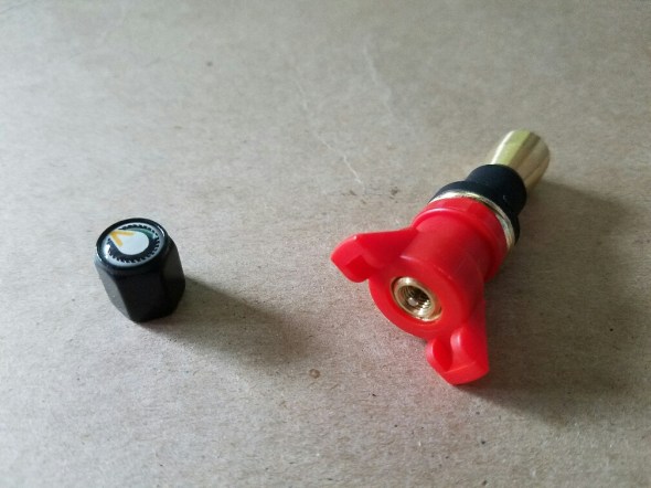
By looking at the two photos, you get how the valve works. First, remove or push in the damaged valve. Then, leaving the valve assembled, you push the Colby valve in the hole until the collar of the black rubber washer is snug against the wheel and then while maintaining some pressure, twist the red handle. The brass stem is drawn up in to the black washer. Due to the taper of the brass stem the black washer expands and seals on the back side (the inside) of the wheel. Tighten until snug. Fill the tire with air.

I think that in every group of wheelers, someone should be carrying one of these. They don’t take up any space and would save a ton of time swapping on the spare tire or worse, trying to in-bead the tire and replace the valve stem. Add it to your tire plug kit.
This product is so cool, I’ve already started to share what I bought. I ordered four of the ’emergency’ valves (there are three styles available) and I’ve already given away two of the valves as prizes at four wheel drive club Christmas parties.
Order up your own at www.ColbyValve.com. They run $28 for a pair of the ’emergency’ style.
For the record, at this time, I am not being paid by Colby nor did I receive mine in exchange for promotion of the product. I’m just really hot on this item!
Rubicon Ronin
Wet conditions. Tread Lightly!
Posted: December 10, 2016 Filed under: Access, Travel | Tags: Rubicon, snow, weather, winter Leave a commentOn my way to the annual Lake Tahoe Hi-Lo’s Christmas Party, I drove by the Rubicon trailhead. It was a little sloppy at the staging area with more than eight inches of slop.
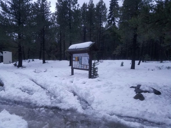
Rain is expected over the next few days, so it’s going to get worse. Imagine this mess freezing up. The temperatures will drop below freezing over night this week but they warm up to the 40’s during the day.
Next weekend the temperatures drop dramatically. We’re talking single digits. Go prepared. And don’t go alone.

The deepest spot was over the bridge, maybe ten inches. With no ground warming, it just doesn’t melt. Be careful crossing the bridge as the ‘sides’ are only eight inches tall. If there is a crown to the snow, you may slide off the side. If you’re concerned about sliding sideways, dig two grooves/ruts to prevent sliding.

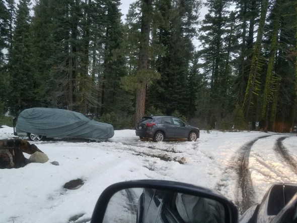
If you’re feeling like it’s too sloppy, you’re being a whimp. Theses two vehicle were parked along the trail and should have no problem getting out.
Weather conditions can change quickly. Always be prepared to spend the night in case of a breakdown. Tent, sleeping bags, winter clothing, water, food, change of clothes, warm snow boots, etc. Prepare for the worst case. You don’t want to be that guy.
The ham repeater system is in place year round. (Thank you RTF and Dennis Mayer!) Carry a radio in case of trouble as cell phones do not work out there. Tell several people where you are going and when you will return.
The side trails in the Eldorado and the Basin are closed. The Tahoe side trails close January 1st. I would suggest staying on the Rubicon at this time of year. That is because the side trails are narrow and off-camber and you could windup in the trees in the blink of an eye. Trust me, you’ll have plenty of fun on the main trail.
Please stay on the trail. Over the snow travel is not permitted for wheeled vehicles. Snowmobiles can go over the snow but don’t follow their tracks in your 4×4.
Get out there and do some snow wheeling but Tread Lightly! and be safe.
Rubicon Ronin
RTF property access finalized
Posted: December 3, 2016 Filed under: Access, Travel | Tags: camping, RTF Leave a commentSo it doesn’t really affect the Tahoe side but it’s important Rubicon news. RTF has finalized legal wheeled access to its property along the Rubicon Trail. The RTF half section is due west of the Rubicon Springs property.

News release from RTF:
RUBICON TRAIL FOUNDATION
Contact: Rusty Folena FOR IMMEDIATE RELEASE
Telephone: 1-888-678-2426
E-mail: President@RubiconTrailFoundation.org
Placerville, CA
December 1st 2016
Rubicon Trail Foundation Property Access
I would like to announce that the Rubicon Trail Foundation and Rubicon Trail Partnership have reached an agreement to access the Rubicon Trail Foundation parcel of land. We have recorded a Boundary Line Adjustment with Rubicon Trail Partnership which will give us two benefits one is access to our nearly land, and the other one is that we will own a quarter mile of land underlying the most famous trail in the world the Rubicon Trail. The Rubicon Trail Foundation would like to thank The Rubicon Trail Partnership for working with us to make this happen. There will be some great opportunities for public access to camp, explore and to enjoy he Rubicon Trail
Stay tuned for more news about what the plan is to access the property. We will have an “Open House” after the snow melts. Follow us on FaceBook and our website link to the Property Page http://www.rubicontrail.org/rtf-property.htm. Hundreds of hours of volunteer work has been done already to help with access to the property. There is more work to be done for sure. The master plan will be released soon, so please stay tuned.
Thank You
Rusty Folena
The Rubicon Trail Foundation (RTF) was formed in 2004. We are a 501(c)3 non-profit corporation dedicated to the future health of the Rubicon Trail and our mission is to enhance the future health and use of the Rubicon Trail, while ensuring responsible motorized year-round trail access. FOTR (Friends of the Rubicon) and RTF works with individuals, 4×4 clubs, organizations, and agencies to maintain and manage the trail. Our Officers and Directors represent a wide variety of Rubicon Trail OHV users, land owners, county representatives, manufacturers, and event organizers.
If you would like to help with our efforts, you may send your tax deductible donations to:
Rubicon Trail Foundation PO Box 2188 Placerville, CA 95667 Paypal donations or major credit cards by calling 888-6rubicon or by signing up for a Friends of the Rubicon work party at: http://www.friendsoftherubicon.com
More information is available at http://www.RubiconTrailFoundation.org To schedule an interview with a representative of the Rubicon Trail Foundation, please e-mail president@RubiconTrailFoundation.org
The map below is virtually the same as above but outlines the parcel west (left) of the RTF parcel, highlighted. You can only imagine that the RTP owners gave up the furthest south 1/4 mile of the Rubicon to RTF. Without any knowledge of what actually happened, I’m going to guess RTF got the trail from the split at the Old True Sluice and the Indian Slabs to the southern RTP property line. And some of the property east of the trail in order to access the RTF property.
No doubt, RTF traded some of their property to RTP for this access.

Great to see this settled.
Rubicon Ronin
Deer Valley Trail to reopen in 2017!
Posted: December 1, 2016 Filed under: Access, Travel | Tags: deer valley, ENF Leave a commentThe Eldorado National Forest (ENF) has finalized the decision to reopen the Deer Valley Trail. It will reopen after the a short period of time after the snow melts. This will be a scientific timeframe not one determined by the USFS.
Here is the cover letter:
Dear Interested Citizen:
As the Responsible Official, I have signed the Decision Notice/Finding of No Significant Impact (DN/FONSI) selecting Alternative 3, the modified seasonal closure, for the Deer Valley 4wd Trail Meadow Restoration and Blue Lakes/Meadow Lake Road Maintenance Environmental Assessment (EA).
Details of the Deer Valley 4wd Trail Meadow Restoration and Blue Lakes/Meadow Lake Road Maintenance Project, including the DN/FONSI, EA, and specialist reports can be found on the Eldorado National Forest website at: http://www.fs.fed.us/nepa/nepa_project_exp.php?project=45439 or http://www.fs.usda.gov/projects/eldorado/landmanagement/projects. To obtain a hard copy of the DN/FONSI or EA, please contact Matt Brown, IDT Leader, 530-647-5390 or mrbrown@fs.fed.us.
The Deer Valley 4wd Trail (19E01) will be reopened immediately as conditions permit. The Blue Lakes/Meadow Lake Road (9N01) would be reopened and added back to the Motor Vehicle Use Map (MVUM) after the corrective actions are implemented to bring routes in compliance with S&G 100. These corrective actions are anticipated to be completed in summer/fall 2017.
For additional information concerning this decision, please contact: Matt Brown, Placerville Ranger District, 4260 Eight Mile Road, Camino CA 95709, Phone: (530) 647-5390 or Email: mrbrown@fs.fed.us.
Thank you for taking the time to read this information and for your continued interest in the management of National Forest System lands.
Sincerely,
/S/ Richard G. Hopson
RICK HOPSON
District Ranger
This is the full eleven page decision:
final-dn_fonsi_deervalleymeadowlakerd
Eldorado closes OHV trails early
Posted: November 30, 2016 Filed under: Access, Travel | Tags: ENF, TNF Leave a commentThe Eldorado National Forest has put out the following press release closing its OHV trails on December 1st, tomorrow. For us that means the Richardson Lake Trail but it applies to most all OHV trails on the ENF.
This is unfortunate as the Richardson Lake Trail is covered with snow and not susceptible to damaging the soils under the snow. Maybe in future years we can ask to have the Richardson Lake Trail remain open as an over the snow route for ‘wheeled’ OHV use.
Trails within the Lake Tahoe Basin Management Unit (LTBMU) are also closed for the season but the Tahoe National Forest (TNF) has not posted any early closing yet. The trails on the TNF are scheduled to close January 1st.
Rubicon Ronin
|
|||
|
|||
|

 News Release

