
Grants are out for comments
Posted: March 3, 2015 Filed under: Maintenance | Tags: education, grant, LTBMU, maintenance, OHV State Parks, TNF Leave a commentGrants are out for comments
I’ll apologize up front, this is a long one. Grant funding is hugely important and honestly, I haven’t been active enough over the years. I’ve tried to hit the high points for you. Please take the time to comment on these and other OHV grants currently in the system. If we don’t comment, they won’t hear us.
Let’s start with Placer County.
In 2013, Placer got a nearly $300,000 grant from CA State Parks for the Rubicon Trail. It ran from Oct of 2013 to Oct of 2014. Placer County did not apply for a grant in 2014. I’ve already posted about how the work done under that grant fell short of many peoples and government agency expectations.
The community was hoping that Placer would learn from the 2013 grant and move forward with a follow up grant to finish the work done in 2014, specifically with greater oversight. That didn’t happen.
I’m hearing lots of rumors but nothing has been confirmed. So, I type this as speculation. I’m hearing that El Dorado County wrote and submitted Placer County’s grant proposal on behalf of Placer County. Good news, bad news. I’m good with that because the last I heard, Placer was not going to apply for ANY grant funding. The bad part is it is only a “Planning” grant with NO money for “Ground Operations”.
So, this Placer County grant funds three main points:
“Task 1 – Hydrological Inventory
This task will be performed by professionals with backgrounds in hydrology and geology. This task is of particular importance since, due to drought and climate change conditions, where the water bar and drainage crossings occur on the Rubicon Trail have likely changed and/or are in a dynamic state. The hydrologists will determine and inventory all crossings, including ones potentially impacted by drought conditions.”
“This task will consist of a full determination of all water crossings beginning where the Rubicon Trail begins at the exit of the McKinney residential neighborhood, to the El Dorado–Placer County Line after Cadillac Hill and before Rubicon Springs.”
“Task 2 – GIS Mapping
From the eastern neighborhood entrance, GPS point locations of the water crossings will be obtained and inventoried. This task is important as the locations will be subsequently used in a map to more accurately determine maintenance needs, potential water quality issues, as well as to direct Contractors or those unfamiliar with the Trail to locations along the Trail.”
“Placer County will also solicit input from user groups to include pertinent and some common Trail places of interest. It is important that all GPS point locations given will be relative to a consistent datum. These points will be field checked.”
“Task 3 – Hydrological Assessment
Using the information from Task 1 above, hydrologists and engineers will determine what and where would be the best location for the water to cross the Trail, as well as an assessment of the current functionality of the water crossing. This task will assess if water bars are properly cited, need to be upgraded or replaced, combined, under-sized, or are obsolete.”
“This task is ultimately a maintenance assessment that will be used in subsequent years to plan maintenance improvements for water quality and sediment erosion control. An additional future task would be to re-numerate the water crossings with markers. The re-marking would occur after the assessment, since it is probable that some of the current water bars can be eliminated. Marking and identifying the water crossings on the Trail, will be key in maintaining water quality in future years.”
The money plays out as follows: $89,000.00 in grant funding; $33,400.00 in matching funds by Placer County. That might include volunteer hours/work as matching funds; for a total grand grant of $122,400.00.
Although just a “Planning Grant”, this work will be a great step in repairing and maintaining the Rubicon Trail. I have heard, rumor only, that Placer County is willing to fund some ground work this summer, the summer of 2015.
All three of these points should be supported by OHV users, as I support them.
We’ll move on to the Tahoe National Forest (TNF).
The TNF grant is structured a little differently. The grant cycle for the TNF is January 1st to January 1st. The grant being applied for in 2015 will actually fund the OHV year of 2016.
This “Ground Operations” grant is designed and written to provide “funding to enable Tahoe National Forest (TNF) to meet annual baseline OHV operation, maintenance and monitoring needs from 1/1/2016 to 12/31/2016.”
It covers a vast list of projects and needs:
- Management of the OHV and OSV programs on all four districts.
- Contracts, equipment, salaries, services and supplies
- Monitoring: Soil, water quality, wildlife, plants, cultural sites
- The following activities will occur on or adjacent to the OHV routes (as needed):
- Repair/armor stream crossings
- Erosion and sediment control
- Removal of brush, loose rocks and down logs from the trail corridor
- Installment, repair and replacement of OHV barriers
- Tread maintenance to provide for safety, resource protection, etc
- Purchase, installation and replacement of signs
- Purchase and installation of gates
- Purchase and distribution of OHV trail maps
- Cleaning toilets and other staging area facilities (1-2 times/week)
- Hazard tree removal
- Toilet pumping
- Facility maintenance and repair
- Trash and litter removal
- Posting and maintenance of bulletin boards, signs and other visitor education services
- Water system testing and maintenance
- Purchase of two motorcycles for the Yuba River RD
- Purchase of minor equipment and supplies (hand tools, chainsaw supplies, beacons, safety riding gear, etc.)
If you read that list closely, you saw that it does contain the word “gate”. We don’t like gates. Unfortunately, gates are now part of an OHV reality. They are primarily used for closing seasonal trails, forest service access roads and roads to private property. Let’s stay on top of all forests and make sure that is the only use of gates.
The way I read the grant, the TNF has no major projects in mind with this grant just regular OHV trails maintenance, so, no bridges.
The money equation plays out as follows: $625,701.00 in grant funding; $220,509.00 in matching funds for a total of $846,210.00.
That’s quite a bit of money. But the TNF funds many OHV positions with OHV grant funds. Jeff Wiley in the Susanville office and Susanne Jensen in the Truckee office are just two examples. I wish the LTBMU would fund a dedicated OHV person for the Basin.
The TNF also has a grant for “Planning”. This grant covers:
- Identify existing public motorized access easement “gaps” in the Tahoe NF’s network of OHV/OSV designated trails and roads.
- Prioritize the identified easement “gaps” based on importance to OHV/OSV users for potential future acquisition.
- Develop cost estimates for future acquisition of priority easements.
- Develop a plan that identifies a prioritized list of easements, with cost estimates, to acquire for public motorized use, which would then become the basis for a future OHMVR Division Acquisition Grant request.
It reads as the forest wanting to connect a lot of bits and pieces of OHV trails around the forest. Hopefully, this will lead to more through routes and less dead ends.
The money plays out as follows: $55,360.00 in grant money; $21,390.00 in matching funds for a total of $76,750.00.
I will comment on and support both of these grants submitted by the TNF.
Last and possibly least, the Lake Tahoe Basin Management Unit:
This one really makes me wonder about the grant process. Here we go…
Work will occur on the following trails: (Note: all of these trails are open to mountain bikes!)
- Corral Trail – (1 mile) open to Motorcycle and ATV
- Cedar Trail – (2 miles) open to Motorcycle and ATV
- Sidewinder Trail – (1.5 miles) open to Motorcycle
- High Meadows OHV Trail – (1 mile) open to Motorcycle
Conservation activities include:
- Vehicle barriers- Repair of existing and installation of additional barriers to prevent OHV use off the trail system. A gate will be installed to limit vehicle access into restricted areas during seasonal travel closures and large rocks and logs will be used to protect natural and cultural resources.
- Restoration of unauthorized parking areas (approximately 2,500 square feet)
Trail maintenance activities include:
- Brushing (removal of vegetation from within the trail corridor).
- Tread restoration
- Shaping and Compacting soils
- Tread Armoring
- Trail signage
- Informational kiosks
- Volunteer workdays will be offered throughout the trail season
This all sounds like really good stuff. And in reality, it is good stuff. But let’s take a closer look at the details.
The total cost of the entire OHV grant is $137,000. That is the total sum of money the LTBMU has asked for to maintain the entire OHV system within the Basin.
Further in to the details, we learn that this grant is only written to repair/maintain five and a half (5.5) miles of OHV trails. Again, those five and a half miles are motorcycle/ATV routes that are open to mountain bikes. At $137,000 for 5.5 miles equals $4.50 per FOOT!!!!
So, the Basin has asked for no money for any other OHV trails, specifically, no money for any four wheel drive trails. No money for the Rubicon corridor, including the staging area. No money for the Twin Peaks area. No money for the Buck Lake Trail or the Middle Fork Trail near the Rubicon.
No money for management or supervision. For as long as I can remember, there has been no lead person for dealing with OHV within the Basin. Every time you approach them about OHV, you speak to someone new. They need a ‘point’ person for all things OHV. Grant funding can do that for them but they don’t ask for it.
The volunteer group listed within the grant is TAMBA. That’s the Tahoe Area Mountain Bike Association. Is this an OHV project or a mountain bike project? Why is there no motorcycle or ATV group associated with this grant?
Where is the money for four wheel drive clubs? Just to mention a few: the Hi-Lo’s, North Tahoe Trail Dusters, South Tahoe Sami’s, Rubicon Trail Foundation, FOTR, Cal4, United, BRC, etc.
Detailed within the grant is a contract with Sierra Buttes Trail Stewardship (SBTS). This group has done a lot of trail maintenance work all over the Sierras. All of that work has been mountain bike trails. Some of the trails also allow motorcycles but not all of them. The kicker, the contract is worth $68,500!!!! Again, an OHV grant or a mountain bike grant?
Do you know what a four wheel drive group could do with $68,500? We could buy a lot of rock and protect a lot of creek crossings and meadows in order to prevent future closings. And be sure, there will be future closings. Some anit-OHV person will sue and the Basin will say they have no money to deal with the issue and the trails will close.
I do not like this grant. I feel it is the LTBMU using OHV money to maintain mountain bike trails and not getting ANY money for four wheel drive trails. The grant is legal and follows the rules, but it stinks!
The Basin has many OHV groups that have adopted trails and many groups that are trying to get more adopted. The Basin doesn’t want more OHV trails, staging areas and signage adopted. Trust me, I’ve tried.
Please comment on this grant more than any other. The Basin needs to hear from OHV users. There is money out there for OHV. Pressure the Basin to apply for that money. Pressure the Basin to use that money for OHV not mountain bike trails.
So, now you know about the grants pertaining to the Tahoe side of the Rubicon Trail. Give me a day or so and I’ll let you know how to comment on these grants.
Comments are due before April 6th.
Start here:
Money, Money, Money
Posted: February 13, 2015 Filed under: Access, Maintenance | Tags: grant, OHV State Parks, Placer, TNF Leave a comment
Okay, actually, “Grant, Grant, Grant”, literally, a Tahoe National Forest OHV grant.
Yesterday, the Tahoe National Forest (TNF) held an open house in Nevada City to get input from the users regarding the upcoming OHV grant cycle. My apologies for not posting about this meeting BEFORE the meeting, moving forward, I will make every effort to inform you of upcoming important meetings. The good news is that you still have time to comment on how you would like to see the 2015 grant money spent. (Details at the bottom of this post)
The TNF was very open and welcoming to the users and listened to every comment and suggestion. There were specific tables set-up for each district. Maps were plentiful.
Unfortunately, Placer County has decided NOT to pursue a grant during this cycle. This will be the second straight cycle they have decided not to apply for a group. Last year, Placer County had contractors working on the Rubicon using OHV grant funding. Not all of the identified work was completed and some of the work done was done incorrectly or in the wrong place.
The Tahoe National Forest has been made aware of this and is willing to step up and work some of the areas needing immediate attention.
My focus is the Rubicon Trail and the surrounding OHV trails. My letter to the TNF is posted below. Please remember that the TNF also has to maintain the Fordyce Trail and the trails around Boca and Stampede Reservoirs.
The grant outlines are due in early March. They will be made available to the public to review March 3rd -Apr 6th at http://ohv.parks.ca.gov/
Joe Chavez
JoeTChavez@fs.fed.us
TNF Trails Specialist
February 13, 2015
Joe,
Yesterday afternoon, I attended the TNF open house on OHV grant funding. I want to thank the forest for continuing to be open to and welcoming of ideas from the users. Everyone there was happy to address the concerns brought to their attention.
That being said, here are the suggestions I have for the upcoming grant cycle:
1) Continue to fund the positions held by Jeff Wiley and Susanne Jensen. Without these dedicated and professional individuals, the state of OHV within the TNF would be much worse off.
2) Unfortunately, Placer County has decided not to pursue OHV grant funding at this time. I would like to ask the TNF to survey the work done on and near the Rubicon Trail in order to identify possible immediate needs due to the work, some incomplete, done last summer by Placer County’s contractor, specifically, restoring natural seasonal creek crossings across the Rubicon Trail.
3) Another need that I know has been on your list for a few years, is the needed maintenance on Forest Road 03-04, commonly known as Barker Pass Road. Although I’m told it’s not an ‘OHV trail’, but as a ‘road’ it provides access to OHV trails and a quicker route for the delivery of materials needed to perform maintenance to the areas OHV trails.
As a professional firefighter, I’d like to see the road improved so that fire protection and other emergency personnel can access the area in safe and timely manner, improving the ability to protect and serve the OHV trails and users in the area.
4) The last issue I’d like to bring up is signage in the area of the Rubicon Trail and Forest Road 03-04. Along the Rubicon, side trails like the Richardson Lake Trail (mostly, but not completely in the ENF), Ellis Peak Trail, Barker Meadow OHV Trail and the Long Lake Trail could use specific USFS ‘carsonites’ with FS trail numbering, two of the four have proper signage but not FS numbering.
FYI, the Richardson Lake Trail is being adopted, through the ENF, by a Carson City businessman and his company. It would be great if the TNF allowed him to post a sign at the start of the Richardson Lake Trail, on the TNF, in order to better educate the users of that trail and other trails in the area. (I’ll get in touch with Susanne Jensen with this request once she returns to her seasonal position in April.)
The intersection of Forest Road 03-04 and the Rubicon Trail needs the sign replaced. I think it finally has disappeared altogether after many years of being pushed over and or thrown in to the forest. The sign provided directions and distances to Blackwood Canyon and the Tahoma staging area.
Along Forest Road 03-04 and just after the Rubicon Trail, a “No Outlet – Nov 1st thru May 31st” sign is needed. As more and more users recreate on the Rubicon Trail in the winter, I think it’s only a matter of time that a winter user tries to ‘exit’ the area using Forest Road 03-04, only to find not one but three gates before getting to Highway 89. The 03-04 road itself needs FS numbering as well, as it’s not really clear to a new user which way the Rubicon turns.
Further along Forest Road 03-04 there are many, many side trails. Although lower on my personal wish list, these side trails should be numbered to better let users know where they are as they drive 03-04 or if they are looking for a specific side trail.
Again, I would like to thank the TNF for the opportunity to voice my opinion regarding the upcoming OHV grant cycle. I look forward to another successful OHV season working with the TNF.
Doug Barr
www.TheOtherRubicon.com
Lake Tahoe Hi-Lo’s
North Tahoe Trail Dusters
Comments are being accepted through February 23, 2015.
Please send your thought to Joe Chavez. JoeTChavez@fs.fed.us
Sign updated at staging area
Posted: January 29, 2015 Filed under: Access, Maintenance, Travel | Tags: education, El Dorado County, FOTR, Placer, RTF, Rubicon Leave a commentAs was the subject of the last “Photo of the month”, the sign at the McKinney-Rubicon Springs Road has been in the need of attention for some time.
Recently, some new material was installed along with a new piece of backing plywood and a new plexi-glass cover. Additionally, the broken map box was replaced and stocked with both the RTF Rubicon Trail map and the new Rubicon Area OHV Trails map and flier. The map was covered in my last post.
Here is the new signage in all it’s glory:
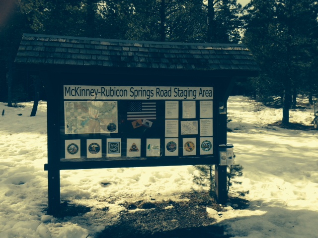
The RTF map is on the left.
The agencies involved with the trail are represented across the bottom: Placer County, El Dorado County, US Forest Service, CA State Parks OHV, Friends of the Rubicon, Rubicon Trail Foundation, CA Association of Four Wheel Drive Clubs, and the Blue Ribbon Coalition.
Towards the right is some educational information including ham radio frequencies, contact information for the agencies involved, how to volunteer, driving cautions and a copy of the new tri-MVUM map.
A close up of the new map box now housing the RTF Rubicon Trail map and the new tri-MVUM of Rubicon Area OHV trails:

This was a private effort. Hopefully, in the future, the agencies listed on the sign will get together with the users to decide what more signage and information is needed at the staging area and along the trail.
UPDATE 2-20-15:
The LTBMU visited the staging area and decided that the sign needed a few changes. Here is a photo of the current sign. I’m working on getting FOTR to join the party and hopefully, together, we can all get the information on the sign to reflect what the users need to travel safely and enjoy the area.
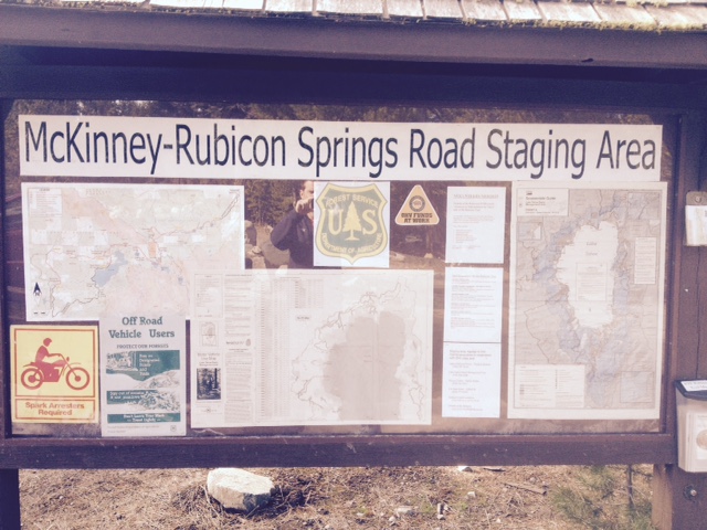
They added a full Motor Vehicle Use Map for North Tahoe and a snowmobile riding area map.
New Tri-MVUM map for Rubicon area
Posted: January 27, 2015 Filed under: Access, Travel | Tags: El Dorado County, Placer, Rubicon Leave a commentIt’s only a first draft but here is a new map of the Rubicon Trail area:

This map combines the three Motor Vehicle Use Maps (MVUM) from the Tahoe National Forest (TNF), the Eldorado National Forest (ENF) and the Lake Tahoe Basin Management Unit (LTBMU). This issue only comes up on the Placer side as the ENF MVUM map covers the entire Rubicon on the El Dorado side.
This map will provide the users with a guide to side trails in the area from Blackwood Canyon to Sourdough Hill. This map is provided for reference only. It is not intended to be used to navigate. Most of the trails listed on this map are seasonal use only, for wheeled motorized vehicles. It is the users responsibility to know when the trails are open for use.
The backside of this map has user information including trail names to go with the FS trail numbers, ham radio frequencies and contact information for Rubicon agencies:
As I said, first draft. This version started as a scan of the three MVUMs. Not a great quality to start with. As I’m new to Photoshop, the resolution was not set to the optimum setting. I’m already working on a new map, from the online FS maps, that should be of good enough quality to enlarge to a size suitable for the trailhead sign.
Although the forests involved would probably rather see ALL the data left on the maps, in future drafts I’m going to eliminate some of the clutter, including all the labeling of the really short trails. That would be all the 003-004-07 kind of numbers.
The LTBMU labels private property vs forest lands differently than the other two forest. Not noticeable in this version. The border between the forests gets a little lost but is the solid black line. No lines for the two counties. The two wildernesses are marked but only one is labeled. Again, first draft. The different forests use different styles to mark the OHV trails. I tried to get the LTBMU and the TNF the same but I’ll wait for the next draft to make the ENF trails look the same.
As crude as this first draft is, these fliers are currently available at the Tahoma Staging Area.
I wanted to get these out so I could get some feedback on the idea. Please let me know what you think these maps need to make them worth while.
Thanks!
Winter on the Rubicon
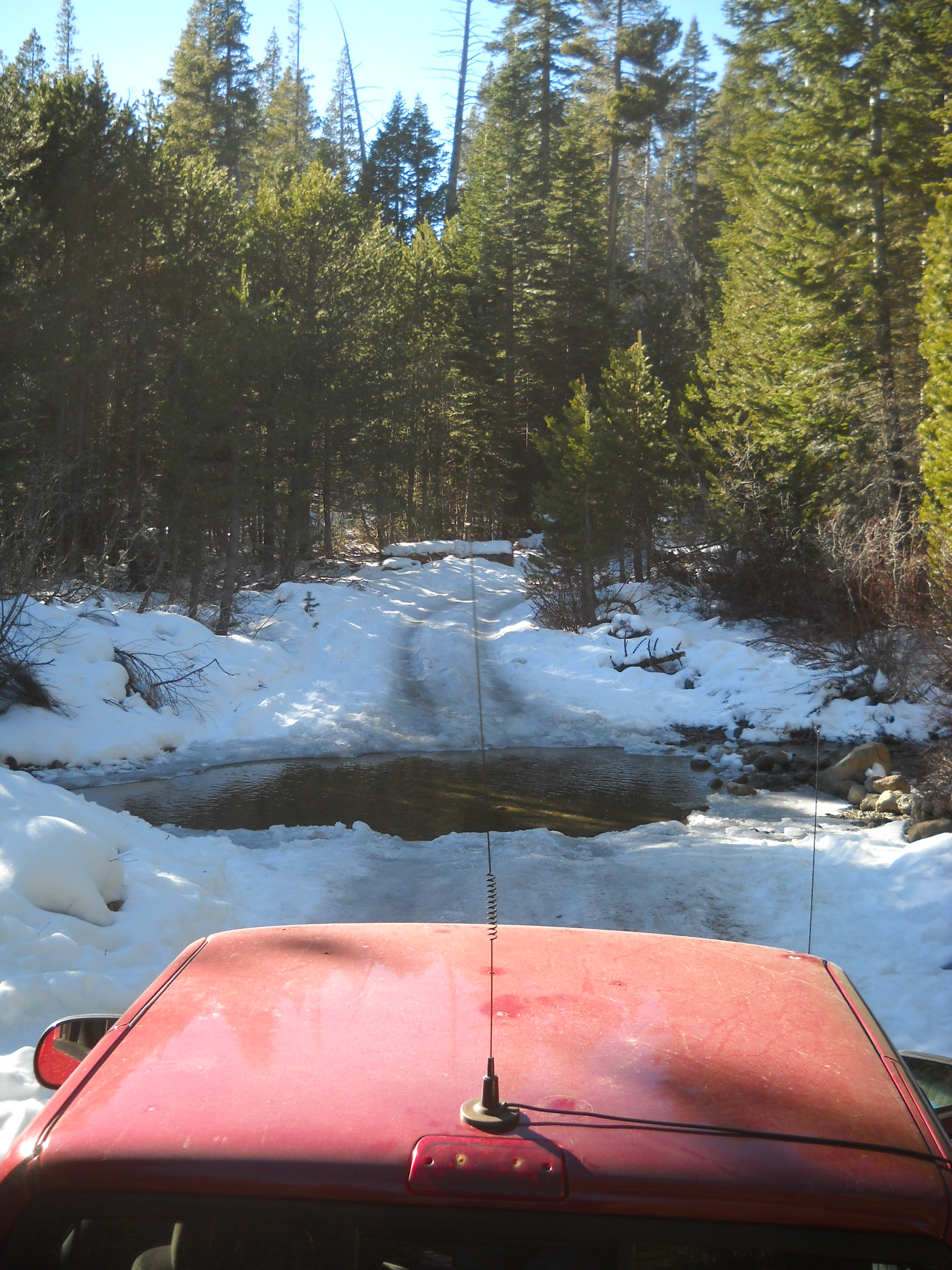
Posted: January 8, 2015 Filed under: Uncategorized Leave a commentI drove out to the Rubicon yesterday. Being alone and in my street truck, 2002 ZR-2, I didn’t venture too far.
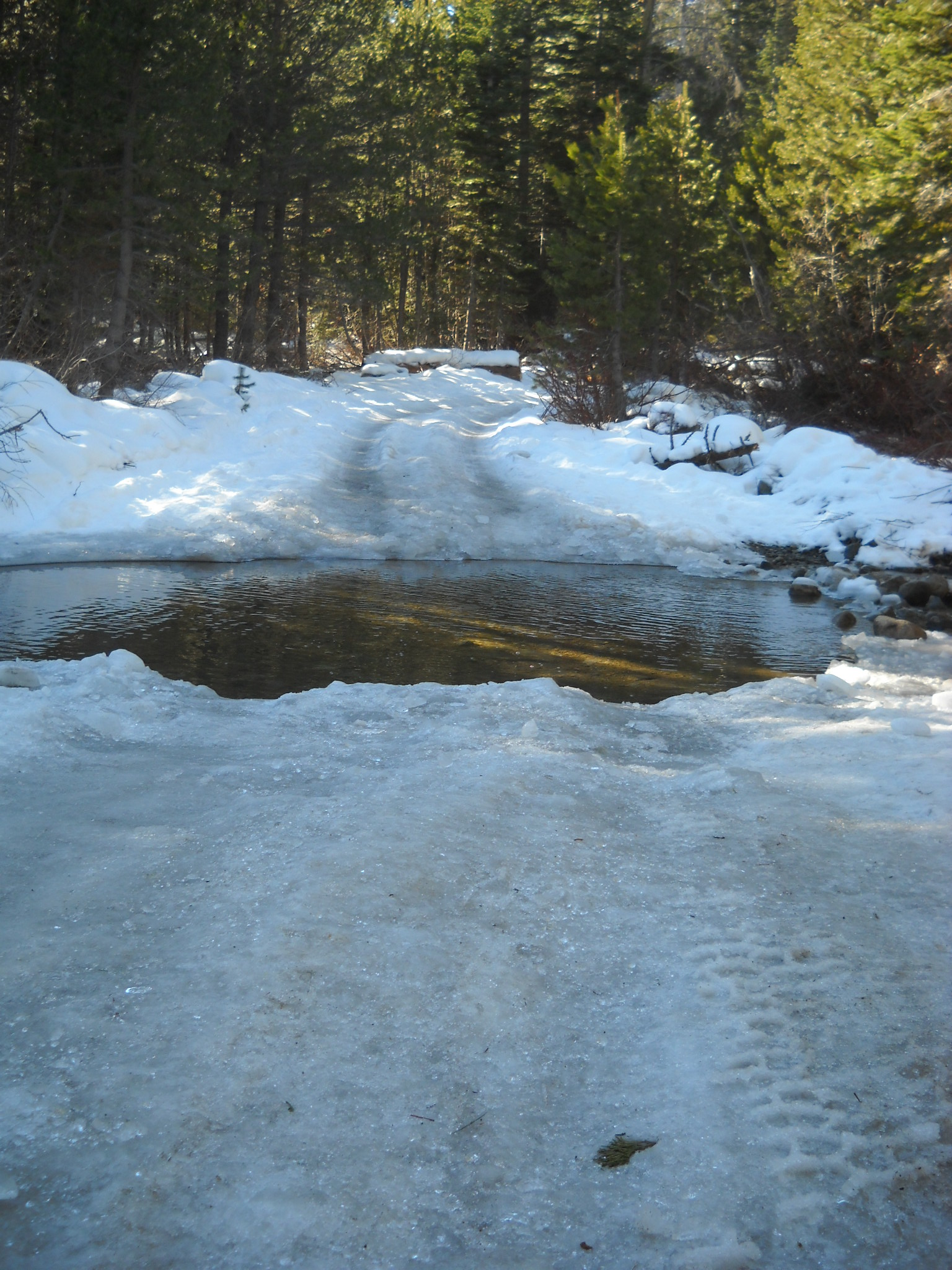
Here is my truck at water bar number eight, actually an Arizona crossing. It’s about a 1/8 mile past the intersection with the Buck Lake Trail. The trail was very icy due to the warm day temperatures and below freezing nights.
Plenty of evidence of people out playing on the trail.

Just before WB#8, someone took the time to clear a downed tree from the trail. Thank you to all of you who take care of business while you’re out on the trail. If you document your time and the people involved, we can get credit towards grant fund matching. Forward any documentation to FOTR.

Please remember to go prepared.
“Turn around, don’t go around.”
If you come across a downed tree or other obstacle and don’t have the means to clear the trail, turn around and head home. Do not drive around the blockage. If you have a chain saw or what ever it takes to clear the trail, feel free to do so but be very careful. This time of year there is less traffic on the trail. If you hurt yourself, you might not see someone drive by for days.

