
Long Lake Trail opens Saturday
Posted: April 21, 2015 Filed under: Access, Maintenance | Tags: access, Hi-Lo's, Long Lake Trail, TNF Leave a commentThe Tahoe National Forest (TNF) Motor Vehicle Use Map (MVUM) has the Long Lake Trail opening on Saturday the 24th. Last weekend, the Lake Tahoe Hi-Lo’s got permission to run the trail early to make sure it was open and safe for the general public.
We drove down Saturday morning without a major issue. One guy heard a rattle and after borrowing a 1/2″ coarse thread nut from a fellow traveler, we were on our way.The run in was a very casual pace. It was nice not to be rushing to get somewhere for a specific time.
The Long Lake Trail only had one tree down but it was rather large:

The nice part was that it was rotten and cut very easily. It actually broke apart as we tried to winch it out of the trail.

We made camp at the campsite along the trail. Other than the two geese that woke everyone up at 6:30am, it was an uneventful stay at the camp. Rain clouds threatened over night. but it never rained.
The drive out was slow and steady. No break downs but some challenging spots going up Cadillac Hill. It seems the rocks continue to “grow” out of the mountain. Future maintenance will be needed to prevent further erosion along Cadillac Hill.
So, the Long Lake Trail is open for business. Please stay on the trail and remember that it ends 0.91 miles in. Also, the campsite is one way in and one way out. Please do not attempt to make it a drive through. Any off trail driving/riding could get the trail closed.
If you come across any issues with the trail or have any questions about the Long Lake Trail, please email me or the Lake Tahoe Hi-Lo’s at LakeTahoeHiLos@Gmail.com.
Enjoy
The season begins
Posted: April 20, 2015 Filed under: Uncategorized | Tags: access, Hi-Lo's, Long Lake Trail Leave a commentLast week I checked out the Rubicon for the first time this season. There was evidence of trees that had fallen across the trail but had been cleared, but no snow to speak of.
That was a little different on the Richardson Lake Trail, 14N39. This trail opened on April 1st. That is earlier than most side trails along the Rubicon. My plan was to drive the trail up to the gate at the Pacific Crest Trail (PCT) and clear any trees across the trail.
Along the way, I came across a few snow drifts on the trail, mostly on the northern aspect of the hill. Some had tracks of previous travelers but the last few did not. It’s a cool feeling knowing you are the first person of the season to run the trail. As long as I was breaking trail going uphill, I felt I was okay. Although alone, I had a winch, gravity and all my other recovery tools if I didn’t make the climb.
When I crested the climb and came across another snow drift in front of me going downhill. It was time to turn around.

This drift was no larger than any of the others I had already driven through that day but it was downhill. If I got stuck, I’d have to winch against gravity or further down the hill. If I had another vehicle with me, I would have driven it for sure. Maybe next time.
The snow is melting fast. I suspect most of the snow in that picture is now gone.
The Hi-Lo’s drove down to the Long Lake Trail on Saturday to open the trail for next weekend. There was one HUGE tree across the trail but it’s been moved. That trail opens to the public on April 24th. I’ll post a detailed report when I get some pictures from my fellow Hi-Lo’s. Enjoy!
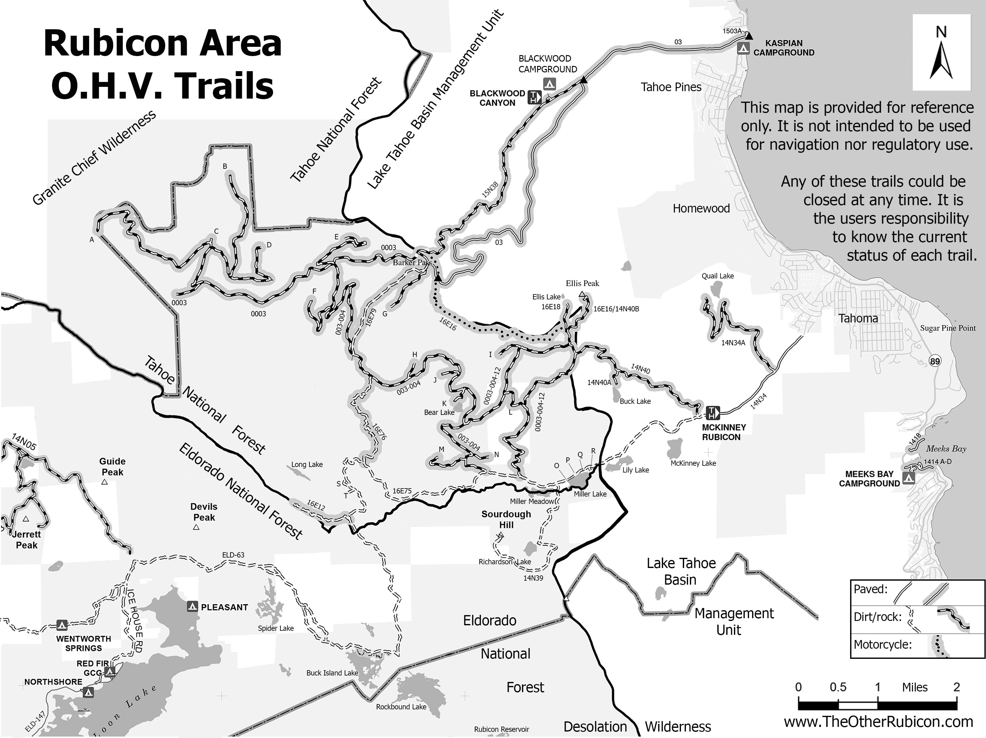
New Rubicon Area OHV Trails Map
Posted: March 18, 2015 Filed under: Access, Travel | Tags: access, education, ENF, LTBMU, rubicon trail, TNF Leave a commentSo, some time ago, I posted a new map of OHV trails in the area of the Tahoe side of the Rubicon Trail. Since then, I’ve learned a lot about using Photoshop. The old map was 72dpi, the new map was 300dpi. The old map was a cluttered mess. The new map is leaner and cleaner.
I’ve bounced different drafts off a lot of people including those within the Forest Service (FS). Some in the FS were not overwhelmingly in support. Some had concerns over the possible differences between my map and current MVUM provided by the FS.
I’ve gone further to distance this map from the official FS MVUM. The FS MVUM is a legal document used to notify the public as to what trails are open for public use. This new map is not intended for navigation nor is it to be used to determine what trails are currently open. This map displays ALL the OHV trails in the area but does not report which are open and which are closed. All but the Rubicon are seasonally closed. At least one is partially closed due to meadow issues.
It is the users responsibility to know where they are at all times and the status of the trail they are driving. Please visit the forest website and read all forest orders that may apply.
Hot off the presses:
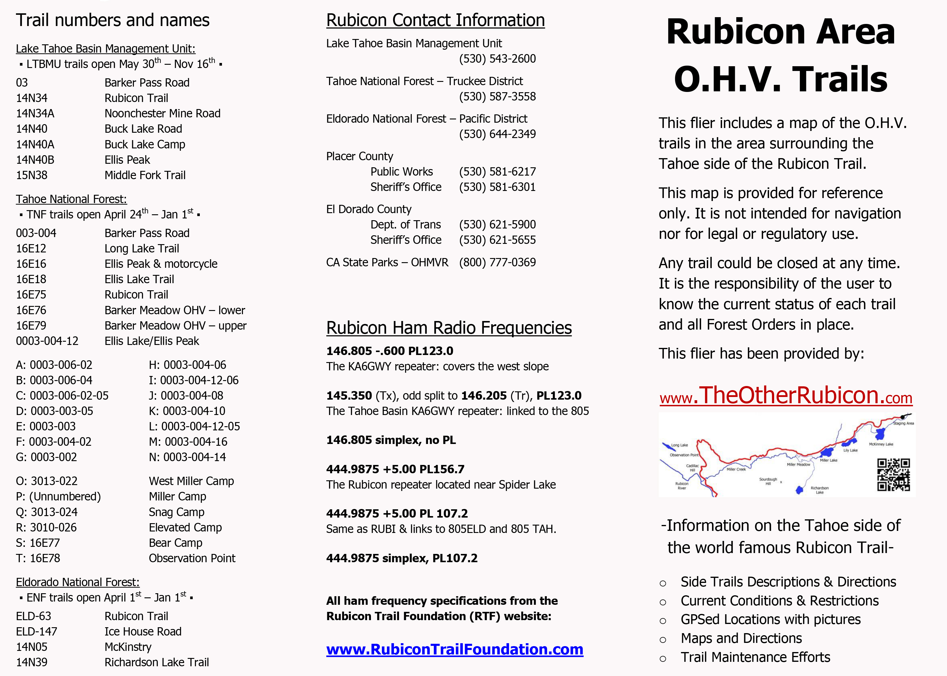
I’ve created a flier from this map to be handed out to users. Here is the front side of the flier with information on the names of trails, seasonal dates for the opening of those trails (which could be changed at any time), ham freqs, agency contact information, etc.
I’ll be handing this map out at the Reno Motorsports Show this Friday and Saturday. The maps will be there Sunday but I have to work. Stop by and pick up a few. I’m still open to comments about what could make this a better map for the users.

