
OHMVR Grant Funds at Risk
Posted: December 14, 2016 Filed under: Uncategorized | Tags: CORVA, education, grant Leave a commentAs a new CORVA (CA Off-Road Vehicle Assoc.) Field Representative, I felt the responsibility to phone in to and participate in the Board of Directors meeting Monday night. It is an open meeting, anyone call phone in and participate or just listen. For the most part, it was your typical meeting reviewing minutes, President’s report, old business, etc.
The one thing that jumped out at me was someone (sorry I didn’t note who brought it up) spoke about the new CA Senate Bill SBX1-1. Look it up. (I think there’s a similar one in the Assembly.) In a nut shell, it proposes the ability to change the allocation of the gas tax revenues that usually funds CA State Parks OHVMR grants to be used for all things vehicle related such as general highway repair, adding bicycle lanes to state roads, etc.
I’m not a legal scholar, so I’ve provided a link to the bill below for you to review the bill as well as copied the two paragraphs from the bill that I think sum it up:
https://leginfo.legislature.ca.gov/faces/billNavClient.xhtml?bill_id=201520161SB1
(8) Article XIX of the California Constitution requires gasoline excise tax revenues from motor vehicles traveling upon public streets and highways to be deposited in the Highway Users Tax Account, for allocation to city, county, and state transportation purposes. Existing law generally provides for statutory allocation of gasoline excise tax revenues attributable to other modes of transportation, including aviation, boats, agricultural vehicles, and off-highway vehicles, to particular accounts and funds for expenditure on purposes associated with those other modes, except that a specified portion of these gasoline excise tax revenues is deposited in the General Fund. Expenditure of the gasoline excise tax revenues attributable to those other modes is not restricted by Article XIX of the California Constitution.
This bill, commencing July 1, 2016, would instead transfer to the Highway Users Tax Account for allocation to state and local transportation purposes under a specified formula the portion of gasoline excise tax revenues currently being deposited in the General Fund that are attributable to boats, agricultural vehicles, and off-highway vehicles. Because that account is continuously appropriated, the bill would make an appropriation.
This could be a huge blow to funding OHV maintenance and repair. Along with this bill, the entire OHMVR program is coming up for review (it will go away unless it gets voted to continue) and the OHMVR division will be rolled into the CA State Park system and no longer be a different division.
These are a lot of changes facing our grant source all at one time.
CORVA is on it. They are already voicing support to renew the OHMVR program. They are keeping an eye on how this system will be managed under CA State Parks directly. And they are aware of and will work to correct any bill that would defund or reduce funds to our OHV grant program.
As a life member of CORVA, I would ask that you help support the efforts of CORVA in this issue and the many others that CORVA champions. www.CORVA.org
Rubicon Ronin
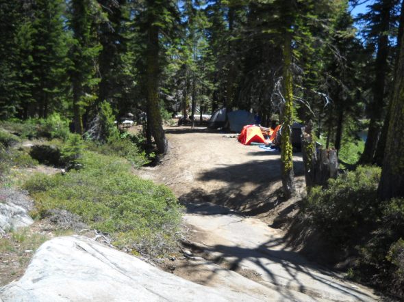
Tahoe side points of interest
Posted: October 16, 2016 Filed under: Travel | Tags: education, Placer, Rubicon Leave a commentBoth Placer County and the Lake Tahoe Basin Management Unit (LTBMU) are looking for a list of Tahoe side points of interest along the east half of the trail within Placer County.
The LTBMU is putting together a new map for the staging area and would like to add these points. I think Placer wants them for a map for their website.
Here is what I have so far, please let me know what I’ve missed or if you call any of these by a different name:
Highway 89
Entrance @ Residential
Quad Rental Parking
FS 14N34: Noonchester Mine Road
Overflow/size Parking
Bridge (Car Wash)
Staging Area
Gatekeeper (sort-of)
FS 14N40: Buck Lake Trail
TNF/LTBMU boundary
FS 3102-26 (turnout)
Adopt-A-Campsite: Elevated
Adopt-A-Campsite: Snag
FS 3102-24 (Campsites across from Miller Lake)
Boat Ramp
FS 3102-22 (Campsite on west end of Miller)
14N39: Richardson Lake Trail
The Pond
FS 03-04-12-05: Ellis Peak Trail
FS 03-04: road to Barker Pass
Pacific Crest Trail
Bottom Dollar Hole
Potato Patch
Old Water Hole (filled)
FS 16E76: Barker Meadow OHV Trail (lower)
Hummer Bend
Helicopter Flat / Birthday Cake (the mountain in the distance)
FS 16E77: Bear Camp
FS 16E78: Observation Point
Trees Section
Creek Crossing (with log water bar)
Upper Hairpin
Morris Rock (The Steps)
The Notch (Squeeze Rock)
U-Rock (Formally V-Rock)
The Cadillac (over the side of the trail)
S-Turn
Lower Hairpin
Roots & Rocks Section
Granite Outcropping – alternate route
The Driveway
The Graves
FS 16E12: Long Lake Trail
Miller Creek
County Line
Cadillac Hill bypass blocked
Posted: September 20, 2016 Filed under: Access, Maintenance, Travel | Tags: access, education, law enforcement, maintenance, Placer, Rubicon, TNF Leave a commentAuthor’s note: I was going to hold off on this just to space out my posts but a conversation online just now made me decide to post it. For the record, I don’t alter the trail. I repair the trail. My work is pre-approved by the Tahoe National Forest or involves getting water off or across the trail in order to minimize erosion. (Also pre-approved; generally not specifically.)
Unfortunately, there are those out there that alter the trail for their own personal gain, either making the trail easier or making the trail harder. Some are trying to do good work but skip too many steps and the work doesn’t last and sometimes hurts.
In order for keep our trails open, safe and maintained properly, we must all speak up when our opinions are being asked. We should volunteer when we can. Comment on grants, attend your local FS meetings, join organizations that fight for your ‘pursuit of happiness’! Rant Off.
A new illegal bypass has appeared on Cadillac Hill this summer. I don’t know when it appeared or who started it but it’s not the first of it’s kind. Not twenty yards from this one was a previous attempt to bypass the trail around a difficult section.
You can see the ‘new’ bypass looking straight in to the photo. The top of the old bypass is in front of the bumper of the Jeep on the right side of the photo.
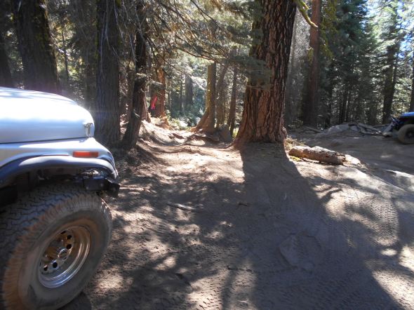
I get that people are tired and sometimes broken when they are driving out, but that doesn’t mean you are allowed to make an easier route. Please stay on the trail.
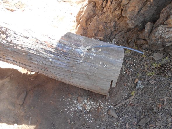
The bypass was blocked by moving a rather large log to block the route.

Both ends of the log were drilled and rebar was placed to prevent the removal of the log. I know this will not prevent those who really want to remove it from removing it but they will have to work at it and they will know they are doing something wrong.

Signs were placed on both sides of the log to let people know that this is the will of the forest service, not an individual.
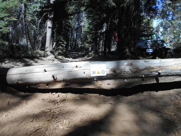
Not wanting to hide from the work I perform under the guidance of the forest service, I put the logo of this website on the sign along with the USFS logo and the CA State Parks logo because they mange and fund respectively a large portion of the maintenance of our OHV trails.
We are our own worst enemy sometimes. Driving off trail and creating new route just gives the anti-OHV people more ammunition to use against us and to close our trails.
We need to work together. There are those who illegally modify the trail to make it harder and there are those who illegally drive off trail to find an easier route. We need to find a middle ground.
If you would like to discuss this issue further, please email me TheOtherRubicon@Charter.net.
Rubicon Ronin
Long Lake campsite
Posted: September 7, 2016 Filed under: Access, Maintenance | Tags: access, education, Hi-Lo's, Long Lake Trail, maintenance, TNF Leave a commentThe Lake Tahoe Hi-Lo’s have adopted the Long Lake Trail (16E12) since it was officially recognized by the USFS in 2014. Since 2011, we have been working with the USFS by bringing FS personnel out there and doing trail maintenance to the point they would accept it, including removing an outhouse and hardening a seasonal creek crossing.
There is a campsite off the trail about halfway down the trail. It is a sharp U-turn to the left and brings you right down along the Rubicon River. This campsite is great for larger groups and offers a quiet change of pace from Rubicon Springs.
Here is the hard left U-turn:
Looking down the campsite, the Rubicon River on the right:
Unfortunately, some people have tried to make this a drive through site by driving off trail, down a granite slab and through a marsh (in spring time). The Forest Service will not allow this ‘through route’.
This was one of three turns off the Long Lake Trail in to the back of the campsite:

This is the ‘backdoor’ in the campsite that in the spring time is a wet muddy marsh:
The Hi-Lo’s have now blocked the ‘through route’ several times. This time we added 4×4 posts with signage explaining the campsite boundary and the possible consequences if the off trail driving continues.
There is now no mistaking this as a possible route to the campsite:

Within the campsite, we added some educational materials to the 4×4 posts:

Having the campsite as a one way in/out is much nicer than a through route. I wouldn’t want anyone driving through my camp at 1am trying to figure out where the actual trail runs.
Also, please note that the trail is only 0.91 miles long. It ends before a 90 degree right turn, an extremely steep climb up a granite slab and another 90 degree left turn; which leads to a boulders strewn seasonal waterfall.
Driving past the recognized end of the trail could result in fines.

Although I do not promote or support driving off trail, the Long Lake Trail is not well defined past the campsite. There are easy routes and extreme routes to get to the end of the trail.
When driving the Long Lake Trail at night, please be extremely cautious. There are steep drops all along the trail. It’s best to have someone walk the trail in front of your rig in order to prevent accidents.
Link to a Photo Journal of the Long Lake Trail.
All I ask is that you always Tread Lightly!
- Don’t drive over bushes
- Don’t leave oil spills on the granite
- Use a WAG bag when camping on granite slabs
- Don’t spin your tires so much you leave marks on the granite
- Leave a clean camp
- Make sure your fire is out cold (Have fires only when restrictions lifted)
- Keep the music down after 10pm
- Pack-it-in, pack-it-out
- Respect other campers
This trail has something for everyone. As long as we respect the trail and each other, we will all be able to enjoy it.
Rubicon Ronin
Traveling 03-04 early in the season
Posted: June 13, 2016 Filed under: Access, Maintenance | Tags: education, maintenance, Rubicon, TNF Leave a commentOn June 12th, at 7am, I headed out from the cabin in Carnelian Bay.
It’s not a long drive around the west side of the lake, only 15-20 minutes, but it was early and there was a chill. Trips like this are why I always have my old ski jacket with gloves and a hat in the Jeep.
Although I was looking forward to the drive time alone on the Rubicon and Forest Road 03-04, it was a work trip. As a volunteer with the Tahoe National Forest (TNF), I have agreed to place trail markers along the Rubicon and on the side trails in the area of Forest Road 03-04. That’s the road from the Rubicon, past Bear Lake that goes to Barker Pass at the top of Blackwood Canyon.
Today, I had a new mileage sign for the intersection of 03-04 and the Rubicon, a no outlet sign for 03-04 (did you read my last post?) and two 03 markers for Barker Pass Road where is meets 03-04.

Using a post hole digger in the Sierra Nevada mountains is not a straight forward process. I start one hole and got about 20″ down when I hit granite. I filled that one in and started another; only got ten inches down. Started a third; eight inches. I went back to the first hole and dug it out again. I figured I’d place a bunch o0f rock around the base to make up for the short hole. I was hoping to get them down at least 24 inches. That was the mileage sign.

I moved up 03-04 to start the “No Outlet 11/6 – 6/14”, the granite rock in the hole were smaller and the center of the hole kept shifting to get around the rocks. But the sign is up.

The day before, I had driven as far north as Bear Lake with the Tahoe Donner 4wdc. Today I would go further and by myself. Yes, I’m setting a bad example. But I had food, drink, shelter, fire starter stuff and a working ham radio.

Just north of Bear Lake, in a downhill section on a northern aspect, there was a sizable snowdrift. I went down it no problem but I knew I’d have trouble on the way out, even if I wasn’t pulling a trailer like I was that day.
I drained a few puddles along the way and had to cut two trees off the trail. The snow drifts were narrow and thus fun to pop over. There were a few longer ones that posed a small challenge but weren’t a problem.

The dirt at the intersection of 03-04 and 03 was very soft for digging but didn’t pack to well after placing the posts.
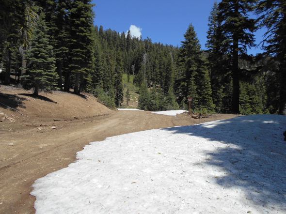
As predicted, on the way out, I had trouble in the large snow drift. Let the winching scenario begin. Of course I wanted to go straight up the trail, there are no trees right in the middle of the trail. So I winched a little to the right and then a little to the left and then once more to the right. But it worked.

The plan was to turn left on 03-04-12 and place some carsonite markers as well but there was a very large drift a short distance up that trail. Maybe in a week or two I’ll try again.

