
Deer Valley Trail – good news!
Posted: August 31, 2016 Filed under: Access | Tags: access, ENF Leave a commentSo the Dept of Fish & Wildlife finally got back top the Eldorado National Forest regarding the re-opening of the Deer Valley Trail.
They agree with the ENF that the re-opening and future work “may affect, but is most likely not to adversely effect” the Lahontan Cutthroat and yellow legged frog.
Here’s the whole document:
We are not out of the woods yet.
- Rick Hobson, Amador District Ranger, will draft his “Final Decision”
- The decision will be posted/published publically
- There will be a 30 day “objection” period (not the same as comments)
- Crabtree will consider any “objection” and will draft his decision
- This decision may include things to address any “objection” such as requiring the approach/departure of the creek crossing to be completed before the trail opens. He could alter the dates of the seasonal closure.
This trail is scheduled to stay open until January 1st. That means two months from now we will be on the trail. Baring any last minute lawsuits that will eventually far short because this has already been to court.
Rubicon Ronin
The Richardson Lake Trail is open!
Posted: August 21, 2015 Filed under: Access, Maintenance | Tags: 14N39, camping, ENF, maintenance Leave a commentFinally,
The Richardson Lake Trail, 14N39, is open!
|
||
|
||
|

Major 14N39 trail work by ENF
Posted: August 6, 2015 Filed under: Maintenance, Uncategorized | Tags: 14N39, ENF, maintenance, Richardson Lake Leave a commentSo, I headed out to the Rubicon to place more carsonite trail markers, and came across a large “Road work ahead” sign at the staging area. I was meeting John Briggs, the Friends of the Rubicon Tahoe side lead. We moved markers at a few of the campsites and later placed markers at the intersection of Forest Road 03 (Barker Pass Road) and 03-04.


After getting our volunteer commitments done, we headed up the Richardson Lake Trail (14N39) to see what was actually going on. We knew that the last ‘meadow’ was scheduled for work but wanted to see for ourselves.
On our way up the Rubicon earlier, we came across a HUGE dump truck. It was a Volvo 725. I believe that means a 25 yard bed. I had earlier asked the size of the hauler (before seeing it) and he said it could do 20 tons. This is a similar machine to the ones Placer used to haul so much material last summer. I think it was the same contractor.

We drove up 14N39 to the Pacific Crest Trail (PCT), where the trail temporarily ends and walked the short distance from there. There we met Tim Merten. He is a Lake Tahoe Basin Management Unit (LTBMU) civil engineer on loan to the Eldorado National Forest (ENF) to deal with the “42 Meadow Route Closures”.
At the ‘meadow’, there was a very large excavator working the section of trail that goes through the ‘meadow’. The plan calls for digging down almost two feet, laying cloth that will prevent the rock from sinking but allow water to pass, placing rip-rap about the size of a football, smaller rock on top of that and finally 3/4 crushed rock as ‘drain rock’. The final product should be able three inches above the grade of the ‘meadow’.


I was told they planned on three weeks to complete the work and I wondered if they were going to place each rock by hand.
What I later learned was the plan also calls for rebuilding twenty five (25) rolling dips along the trail as they work their way out.
With any luck, we’ll be driving to the top of Sourdough by the 20th!
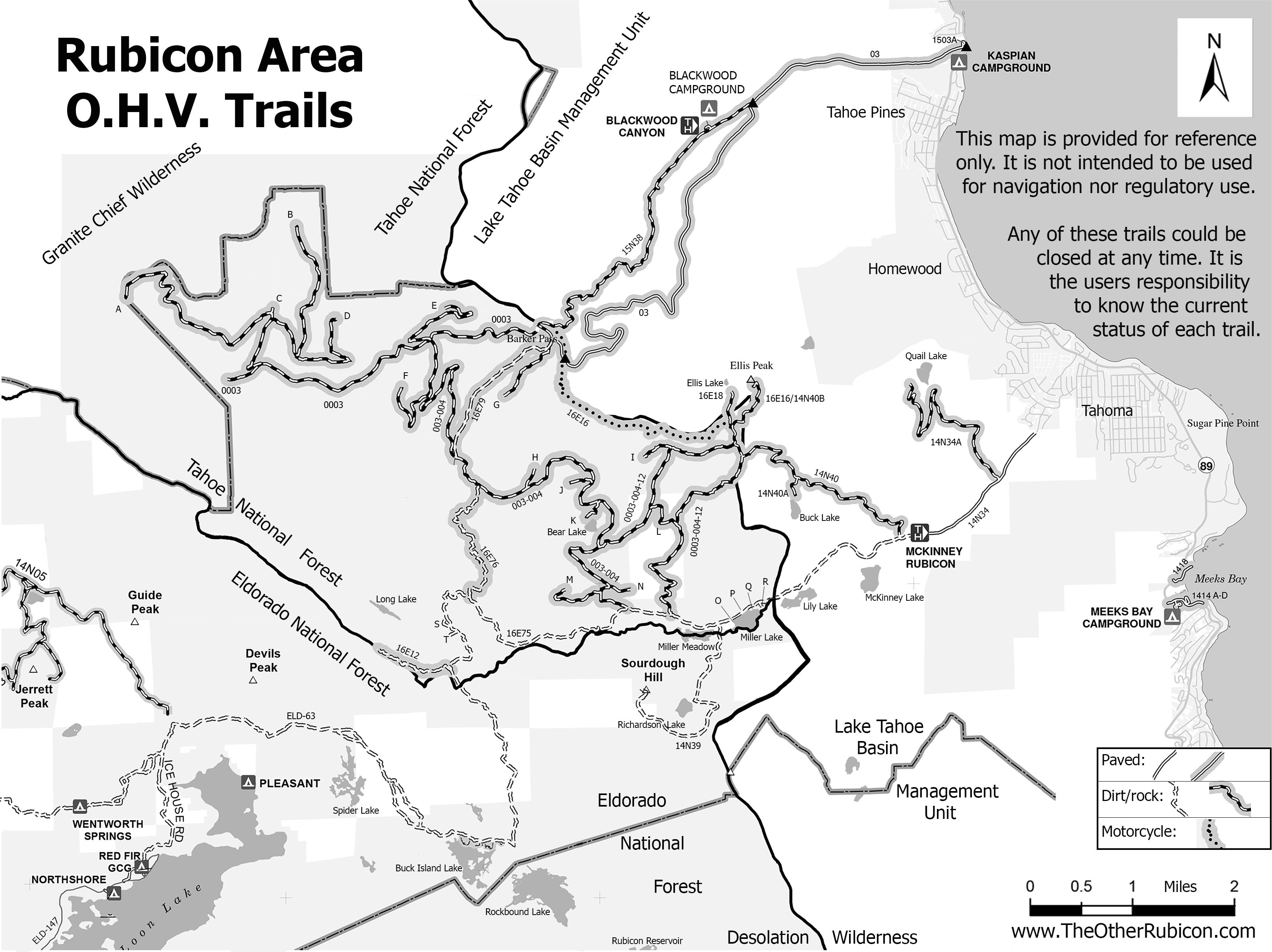
New Rubicon Area OHV Trails Map
Posted: March 18, 2015 Filed under: Access, Travel | Tags: access, education, ENF, LTBMU, rubicon trail, TNF Leave a commentSo, some time ago, I posted a new map of OHV trails in the area of the Tahoe side of the Rubicon Trail. Since then, I’ve learned a lot about using Photoshop. The old map was 72dpi, the new map was 300dpi. The old map was a cluttered mess. The new map is leaner and cleaner.
I’ve bounced different drafts off a lot of people including those within the Forest Service (FS). Some in the FS were not overwhelmingly in support. Some had concerns over the possible differences between my map and current MVUM provided by the FS.
I’ve gone further to distance this map from the official FS MVUM. The FS MVUM is a legal document used to notify the public as to what trails are open for public use. This new map is not intended for navigation nor is it to be used to determine what trails are currently open. This map displays ALL the OHV trails in the area but does not report which are open and which are closed. All but the Rubicon are seasonally closed. At least one is partially closed due to meadow issues.
It is the users responsibility to know where they are at all times and the status of the trail they are driving. Please visit the forest website and read all forest orders that may apply.
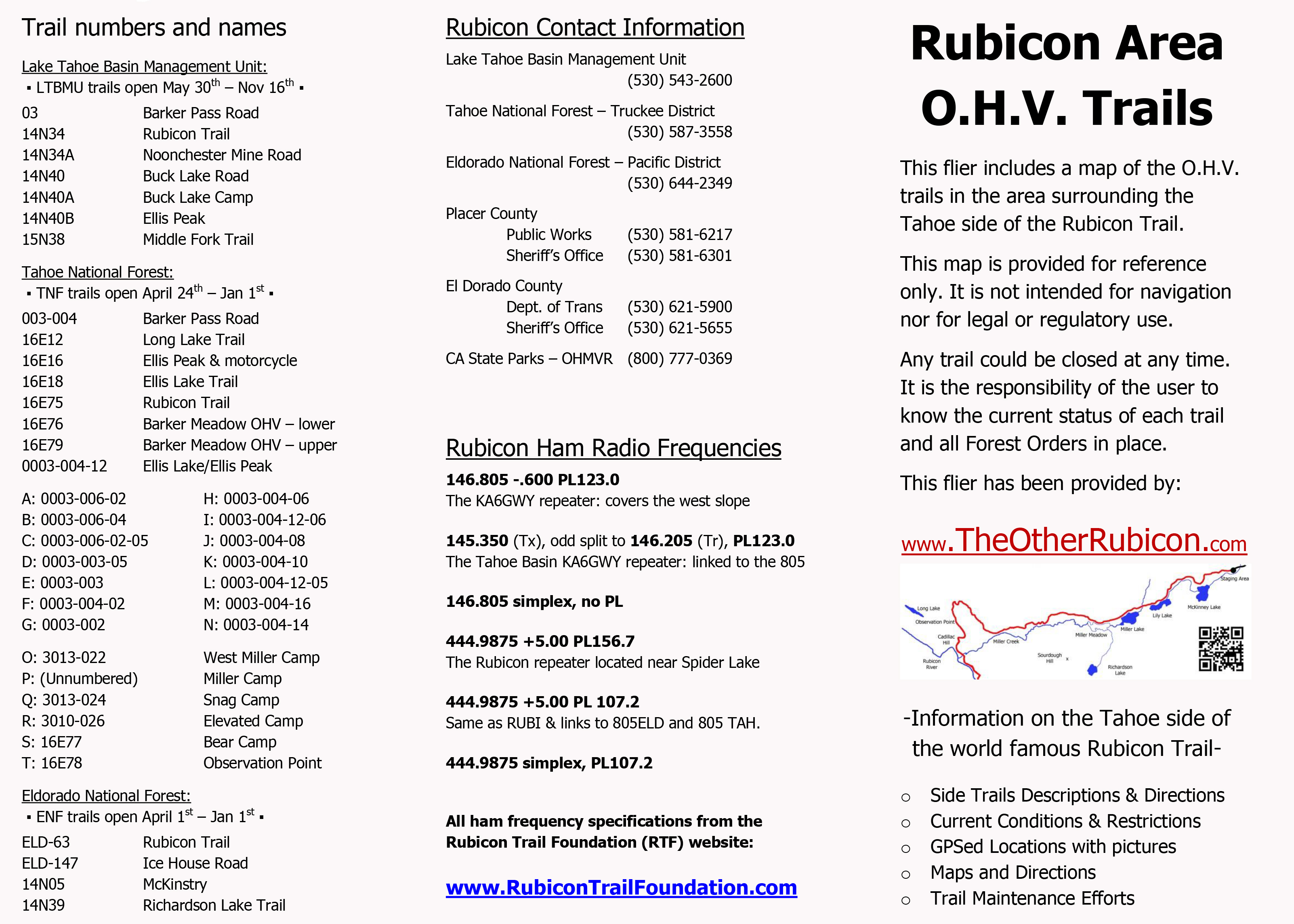
Hot off the presses:
I’ve created a flier from this map to be handed out to users. Here is the front side of the flier with information on the names of trails, seasonal dates for the opening of those trails (which could be changed at any time), ham freqs, agency contact information, etc.
I’ll be handing this map out at the Reno Motorsports Show this Friday and Saturday. The maps will be there Sunday but I have to work. Stop by and pick up a few. I’m still open to comments about what could make this a better map for the users.
LTBMU, ENF & TNF lift fire restrictions
Posted: October 4, 2014 Filed under: Access | Tags: ENF, fire, LTBMU, TNF Leave a comment
The last of the trio of Rubicon forests has lifted fire restrictions. The ENF lifted restrictions as of 10-8-14.
http://www.fs.usda.gov/detail/eldorado/news-events/?cid=STELPRD3819658
Starting 9-30-14, the Tahoe National Forest has lifted fire restrictions for the season.
http://www.fs.usda.gov/detail/tahoe/news-events/?cid=STELPRD3818599
Starting 10-3-14, the Lake Tahoe Basin Management Unit has lifted fire restrictions for the season.
http://www.fs.usda.gov/detail/ltbmu/news-events/?cid=STELPRD3818996
Although I feel this is too early, fires are now allowed with the proper fire permit. Please take the time to make sure the fire is completely out. This means OUT, not just no flames. The fire pit should be cold enough to run your hands through the coals. I usually pour two five gallon buckets of water on the coals and stir as I go.
Several unattended fires have been reported over the past summer along the Rubicon. Luckily, none of them turn in to major wild fires. The only major fire was arson. We did have a few lighting started fires. The one instance I heard of where a camp fire became a wild fire was in Desolation Wilderness, and you know that wasn’t the fault of a wheeler.
Please be safe and help protect our forests.

