
V-Rock now U-Rock
Posted: August 29, 2016 Filed under: Access, Maintenance | Tags: Cadillac Hill, FOTR, maintenance, Placer, RTF, Rubicon Leave a commentSo, I made it down Cadillac Hill this past weekend and noticed that quite a bit of work has been done. Cadillac Hill was easier than I can ever remember.
As you all know, there are several ‘famous’ obstacles along the climb up Cadillac Hill. One of those is V-Rock. V-Rock is (was) a granite slope from above the trail down to the edge of the trail with a large boulder outcropping at the edge. The angle between the granite slope and edge of the boulder created a “V” that users needed to navigate.
So here are two before any work was done. Unfortunately, not all from the same angle. The granite slope on the right slopes up more than the photo implies.

Special nod to Randy for posting a picture of his rig the last time it was running. Note the deep “V” at his front right tire.

Some work was done over the last few years to get the condition below. The “V” still has loose rock so the depth can vary. Drive it as is if so equipped; fill in a bunch of rock if you’re lower or limping out broken.

But now, after a whole bunch of concrete and rock were placed in the “V”, the “V” is now a “U”. And it’s concrete so no chance for a difficult line.
![DSCN0558[1]](https://theotherrubicon.com/wp-content/uploads/2016/08/dscn05581.jpg?w=590)
I asked before on a public forum “Who Decides?” That thread was started about a rock on Cadillac that was drilled and split, without any formal permission. The answer was if it’s a safety issue, take care of it.
What would happen if an individual made the Soup Bowl ‘safe’?
Now there are rumors that even more rocks will be split, removed, dealt with, etc. on Cadillac Hill; during the dark of night with no formal permission or discussion. Does Placer know? FOTR? RTF? TNF?
There is a new bypass on Cadillac Hill in the ‘trees’ section. I can only assume the tight turn was too much for some drivers or some rigs so they went straight through the trees. This is an illegal users created bypass and will be blocked.
In both photos below, you can see a former bypass that was blocked on the right. In the first photo right through my rear view mirror. In the second photo far right and half way up.
Bypass straight ahead, original trail to the right:
![DSCN0513[1]](https://theotherrubicon.com/wp-content/uploads/2016/08/dscn05131.jpg?w=590)
Bypass left of the tree, original trail around to the right:
![DSCN0514[1]](https://theotherrubicon.com/wp-content/uploads/2016/08/dscn05141.jpg?w=590)
I thought people drove the Rubicon Trail for a challenge?
Traveling 03-04 early in the season
Posted: June 13, 2016 Filed under: Access, Maintenance | Tags: education, maintenance, Rubicon, TNF Leave a commentOn June 12th, at 7am, I headed out from the cabin in Carnelian Bay.
It’s not a long drive around the west side of the lake, only 15-20 minutes, but it was early and there was a chill. Trips like this are why I always have my old ski jacket with gloves and a hat in the Jeep.
Although I was looking forward to the drive time alone on the Rubicon and Forest Road 03-04, it was a work trip. As a volunteer with the Tahoe National Forest (TNF), I have agreed to place trail markers along the Rubicon and on the side trails in the area of Forest Road 03-04. That’s the road from the Rubicon, past Bear Lake that goes to Barker Pass at the top of Blackwood Canyon.
Today, I had a new mileage sign for the intersection of 03-04 and the Rubicon, a no outlet sign for 03-04 (did you read my last post?) and two 03 markers for Barker Pass Road where is meets 03-04.

Using a post hole digger in the Sierra Nevada mountains is not a straight forward process. I start one hole and got about 20″ down when I hit granite. I filled that one in and started another; only got ten inches down. Started a third; eight inches. I went back to the first hole and dug it out again. I figured I’d place a bunch o0f rock around the base to make up for the short hole. I was hoping to get them down at least 24 inches. That was the mileage sign.

I moved up 03-04 to start the “No Outlet 11/6 – 6/14”, the granite rock in the hole were smaller and the center of the hole kept shifting to get around the rocks. But the sign is up.

The day before, I had driven as far north as Bear Lake with the Tahoe Donner 4wdc. Today I would go further and by myself. Yes, I’m setting a bad example. But I had food, drink, shelter, fire starter stuff and a working ham radio.

Just north of Bear Lake, in a downhill section on a northern aspect, there was a sizable snowdrift. I went down it no problem but I knew I’d have trouble on the way out, even if I wasn’t pulling a trailer like I was that day.
I drained a few puddles along the way and had to cut two trees off the trail. The snow drifts were narrow and thus fun to pop over. There were a few longer ones that posed a small challenge but weren’t a problem.

The dirt at the intersection of 03-04 and 03 was very soft for digging but didn’t pack to well after placing the posts.
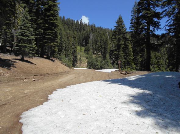
As predicted, on the way out, I had trouble in the large snow drift. Let the winching scenario begin. Of course I wanted to go straight up the trail, there are no trees right in the middle of the trail. So I winched a little to the right and then a little to the left and then once more to the right. But it worked.

The plan was to turn left on 03-04-12 and place some carsonite markers as well but there was a very large drift a short distance up that trail. Maybe in a week or two I’ll try again.
The LTBMU fails to get any OHV funds
Posted: June 9, 2016 Filed under: Access, Maintenance, Travel | Tags: access, FOTR, grant, Hi-Lo's, LTBMU, maintenance, OHV grant, OHV State Parks, Placer, TNF Leave a commentThis OHV season, the CA State Parks OHV Division made available almost $11 million dollars for OHV issues, projects, maintenance, law enforcement, education, etc.
The Lake Tahoe Basin Management Unit (LTBMU) failed to obtain a single penny of it. In comparison, the Eldorado National Forest (ENF) received $438k and the Tahoe National Forest (TNF) received $650k.
There is a 30 day grace period for the agency requesting funds to ask that their grant be reviewed and rescored but don’t hold your breath. This is the second straight year the grant writers and administrators at the LTBMU have fallen short. I think it’s safe to say the LTBMU needs a new grant writing staff.
Here’s the problem, even though the LTBMU didn’t receive CA State Parks grant funding, they are still required to manage OHV on their forest. It’s just going to be that much more difficult without specific funding for OHV.
I’m using this lack of funding problem to push the LTBMU to reinstate the Adopt-A-Trail program they dumped two years ago.
If you or your club, group, business or organization would like to adopt an OHV trail within the LTBMU, email them, call them, hound them, do not take no for an answer, Right now I only know of the Twin peaks Trail in South Lake Tahoe, the Buck Lake Trail off the Rubicon and the Middle Fork Trail up Blackwood Canyon (just north of the Rubicon) that historically have been adopted.
That list doesn’t include the pre-Placer County Rubicon when the Lake Tahoe Hi-Lo’s had the entire east side of the trail adopted. For adopting a section of the Placer side of the Rubicon Trail, contact the Rubicon Trail Foundation.
Here is a list of OHV trails within the basin from the LTBMU website. Not all trails are listed. Check the Motor Vehicle Use Map (MVUM) for more trails.
Lake Tahoe – East Shore
- Genoa Peak Road 14N32
- Kingsbury Stinger 18E39.3
- Logan House 14N33
Lake Tahoe – North Shore
- Kings Beach 18E18
- Mt Watson 73E
Lake Tahoe – South Lake Tahoe
- Corral Trail 18E14
- Hellhouse Road 12N01D
- High Meadows Trail 18E33A
- Power Line Road 12N08
- Sand Pit 12N08
- Sawmill Pond 12N30
- Twin Peaks 12n30
Lake Tahoe – West Shore
- Buck Lake Road – 14N40
- McKinney / Rubicon Trailhead
- Noonchester 14N34A
Please step up, adopt a trail, push the LTBMU to work with the users!
Adopt-A-Campsite Update
Posted: December 15, 2015 Filed under: Maintenance | Tags: access, camping, maintenance, TNF Leave a commentAdopt-A-Campsite Update
This past OHV season marked the beginning of a new Adopt-A-Campsite program on the Truckee District of the Tahoe National Forest.
For the first year of the program, it went well. We had six different campsites adopted by five individuals or groups.
Here is the list of current volunteers:
- Jon & Jan Briggs
- Tahoe Donner 4 Wheelers Club http://gerb58.wix.com/td-4-wheelers-#!
- Doug Barr www.TheOtherRubicon.comThe Other Rubicon
- Sierra Stompers http://www.sierrastompers.org/
- Dominic Bruno
While working with the Forest Service (FS) to get the paperwork straight for each particular site, we discovered that the FS had miss marked the three ‘new’ sites near Miller Lake. So, one of the adopted sites is not yet an official site, as is another that has yet to be adopted.
Hopefully, the FS will get these sites added to the MVUM very soon. My understanding is that the FS is not asking for these sites to be blocked off to motor vehicle access at this time.
For those of you interested in adopting a site, click the link on the right side of my website and look around for a site you’d like to maintain. There is a well shaded site along Miller Lake available as is Observation Point itself. Please email me (TheOtherRubicon@charter.net) if you’d like to adopt on of these two or any of the sites listed.
Duties are much less than adopting a trail. You need to complete the appropriate paperwork to adopt the site and then ensure that paperwork is done for each individual helping you maintain your site. An email letting me know, and I will let the FS know, what you have planned in the way of maintenance and a report at the end of the year is the rest of the paperwork required.
Basic on the ground duties include visiting/maintaining the site at least twice a year to pick up trash, clean out the fire pit (if there is one) and ensure that the site is not growing using logs and boulders to define the borders.
The Richardson Lake Trail is open!
Posted: August 21, 2015 Filed under: Access, Maintenance | Tags: 14N39, camping, ENF, maintenance Leave a commentFinally,
The Richardson Lake Trail, 14N39, is open!
|
||
|
||
|


