
Fire restrictions in place on LTBMU & TNF
Posted: June 25, 2015 Filed under: Access | Tags: LTBMU, TNF Leave a commentAs of July 1, 2015, fire restrictions are in place on the TNF & LTBMU!
I just came across the postings on their websites. The Eldorado won’t be far behind.
Be fire safe even without a fire. Carry water and a shovel at all times.
Long Lake Trail opens Saturday
Posted: April 21, 2015 Filed under: Access, Maintenance | Tags: access, Hi-Lo's, Long Lake Trail, TNF Leave a commentThe Tahoe National Forest (TNF) Motor Vehicle Use Map (MVUM) has the Long Lake Trail opening on Saturday the 24th. Last weekend, the Lake Tahoe Hi-Lo’s got permission to run the trail early to make sure it was open and safe for the general public.
We drove down Saturday morning without a major issue. One guy heard a rattle and after borrowing a 1/2″ coarse thread nut from a fellow traveler, we were on our way.The run in was a very casual pace. It was nice not to be rushing to get somewhere for a specific time.
The Long Lake Trail only had one tree down but it was rather large:

The nice part was that it was rotten and cut very easily. It actually broke apart as we tried to winch it out of the trail.

We made camp at the campsite along the trail. Other than the two geese that woke everyone up at 6:30am, it was an uneventful stay at the camp. Rain clouds threatened over night. but it never rained.
The drive out was slow and steady. No break downs but some challenging spots going up Cadillac Hill. It seems the rocks continue to “grow” out of the mountain. Future maintenance will be needed to prevent further erosion along Cadillac Hill.
So, the Long Lake Trail is open for business. Please stay on the trail and remember that it ends 0.91 miles in. Also, the campsite is one way in and one way out. Please do not attempt to make it a drive through. Any off trail driving/riding could get the trail closed.
If you come across any issues with the trail or have any questions about the Long Lake Trail, please email me or the Lake Tahoe Hi-Lo’s at LakeTahoeHiLos@Gmail.com.
Enjoy
New Rubicon Area OHV Trails Map
Posted: March 18, 2015 Filed under: Access, Travel | Tags: access, education, ENF, LTBMU, rubicon trail, TNF Leave a commentSo, some time ago, I posted a new map of OHV trails in the area of the Tahoe side of the Rubicon Trail. Since then, I’ve learned a lot about using Photoshop. The old map was 72dpi, the new map was 300dpi. The old map was a cluttered mess. The new map is leaner and cleaner.
I’ve bounced different drafts off a lot of people including those within the Forest Service (FS). Some in the FS were not overwhelmingly in support. Some had concerns over the possible differences between my map and current MVUM provided by the FS.
I’ve gone further to distance this map from the official FS MVUM. The FS MVUM is a legal document used to notify the public as to what trails are open for public use. This new map is not intended for navigation nor is it to be used to determine what trails are currently open. This map displays ALL the OHV trails in the area but does not report which are open and which are closed. All but the Rubicon are seasonally closed. At least one is partially closed due to meadow issues.
It is the users responsibility to know where they are at all times and the status of the trail they are driving. Please visit the forest website and read all forest orders that may apply.
Hot off the presses:
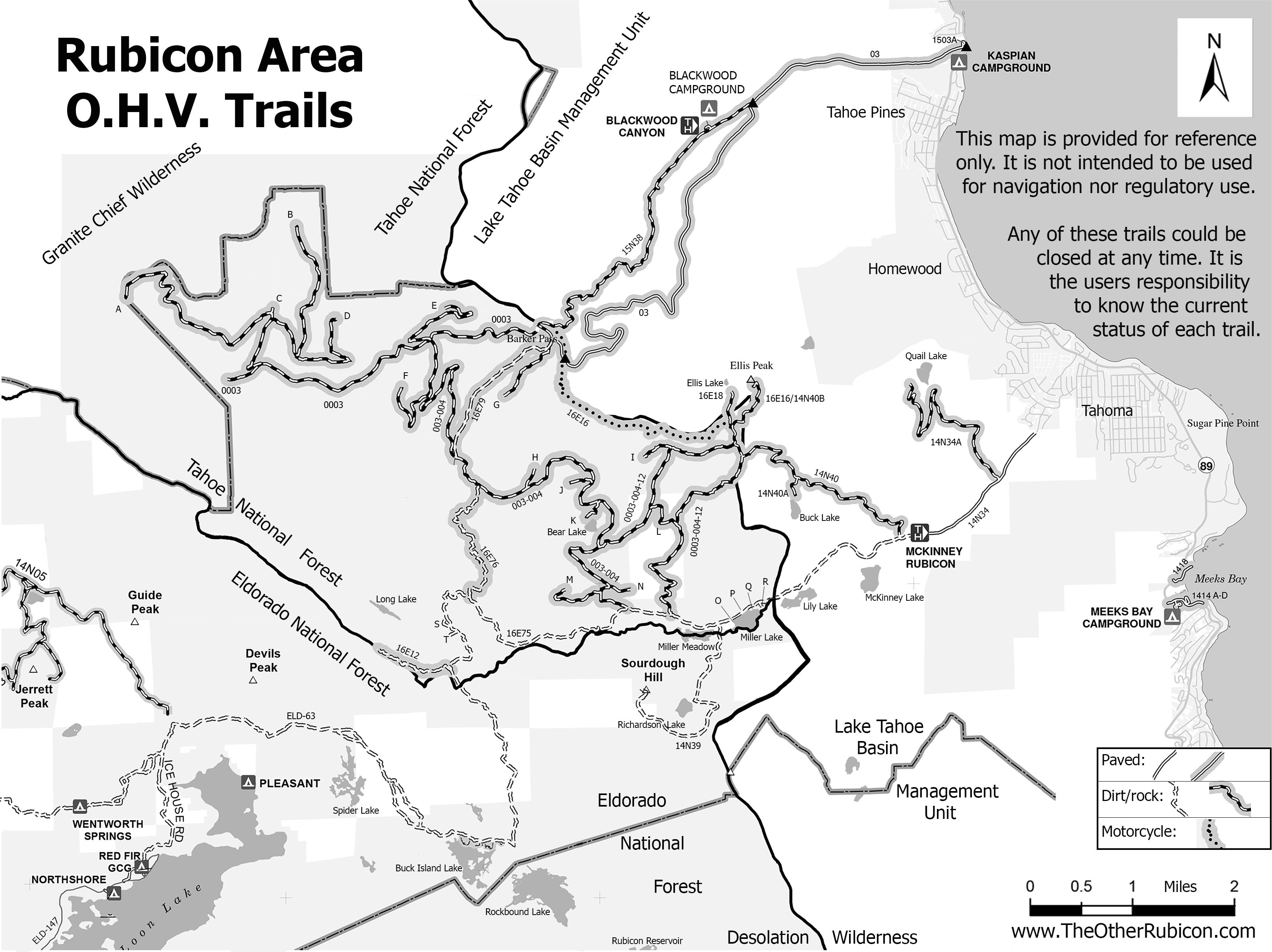
I’ve created a flier from this map to be handed out to users. Here is the front side of the flier with information on the names of trails, seasonal dates for the opening of those trails (which could be changed at any time), ham freqs, agency contact information, etc.
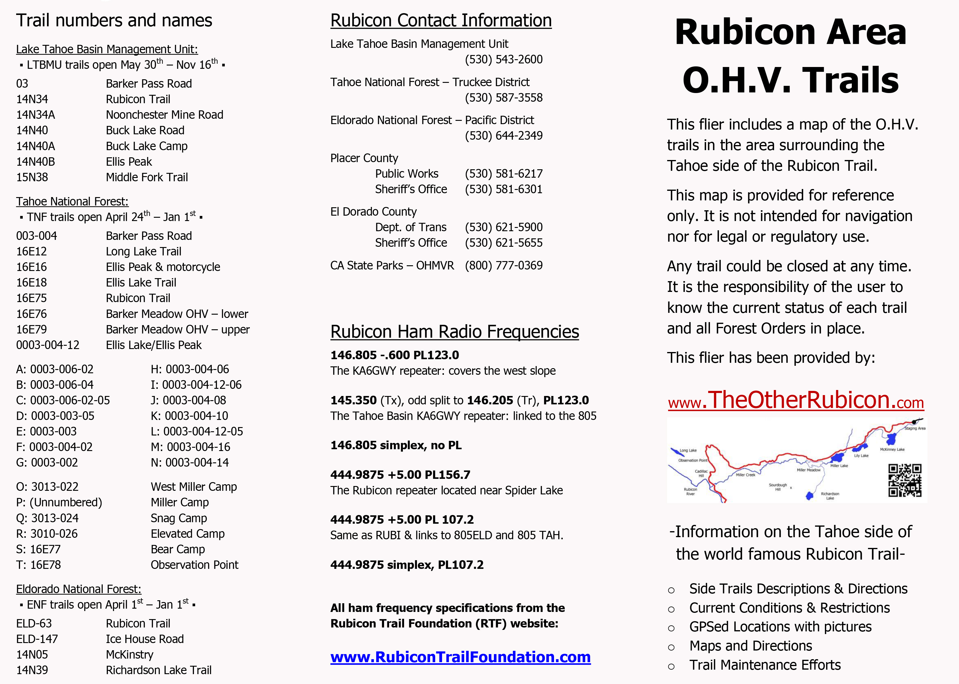
I’ll be handing this map out at the Reno Motorsports Show this Friday and Saturday. The maps will be there Sunday but I have to work. Stop by and pick up a few. I’m still open to comments about what could make this a better map for the users.
Grants are out for comments
Posted: March 3, 2015 Filed under: Maintenance | Tags: education, grant, LTBMU, maintenance, OHV State Parks, TNF Leave a commentGrants are out for comments
I’ll apologize up front, this is a long one. Grant funding is hugely important and honestly, I haven’t been active enough over the years. I’ve tried to hit the high points for you. Please take the time to comment on these and other OHV grants currently in the system. If we don’t comment, they won’t hear us.
Let’s start with Placer County.
In 2013, Placer got a nearly $300,000 grant from CA State Parks for the Rubicon Trail. It ran from Oct of 2013 to Oct of 2014. Placer County did not apply for a grant in 2014. I’ve already posted about how the work done under that grant fell short of many peoples and government agency expectations.
The community was hoping that Placer would learn from the 2013 grant and move forward with a follow up grant to finish the work done in 2014, specifically with greater oversight. That didn’t happen.
I’m hearing lots of rumors but nothing has been confirmed. So, I type this as speculation. I’m hearing that El Dorado County wrote and submitted Placer County’s grant proposal on behalf of Placer County. Good news, bad news. I’m good with that because the last I heard, Placer was not going to apply for ANY grant funding. The bad part is it is only a “Planning” grant with NO money for “Ground Operations”.
So, this Placer County grant funds three main points:
“Task 1 – Hydrological Inventory
This task will be performed by professionals with backgrounds in hydrology and geology. This task is of particular importance since, due to drought and climate change conditions, where the water bar and drainage crossings occur on the Rubicon Trail have likely changed and/or are in a dynamic state. The hydrologists will determine and inventory all crossings, including ones potentially impacted by drought conditions.”
“This task will consist of a full determination of all water crossings beginning where the Rubicon Trail begins at the exit of the McKinney residential neighborhood, to the El Dorado–Placer County Line after Cadillac Hill and before Rubicon Springs.”
“Task 2 – GIS Mapping
From the eastern neighborhood entrance, GPS point locations of the water crossings will be obtained and inventoried. This task is important as the locations will be subsequently used in a map to more accurately determine maintenance needs, potential water quality issues, as well as to direct Contractors or those unfamiliar with the Trail to locations along the Trail.”
“Placer County will also solicit input from user groups to include pertinent and some common Trail places of interest. It is important that all GPS point locations given will be relative to a consistent datum. These points will be field checked.”
“Task 3 – Hydrological Assessment
Using the information from Task 1 above, hydrologists and engineers will determine what and where would be the best location for the water to cross the Trail, as well as an assessment of the current functionality of the water crossing. This task will assess if water bars are properly cited, need to be upgraded or replaced, combined, under-sized, or are obsolete.”
“This task is ultimately a maintenance assessment that will be used in subsequent years to plan maintenance improvements for water quality and sediment erosion control. An additional future task would be to re-numerate the water crossings with markers. The re-marking would occur after the assessment, since it is probable that some of the current water bars can be eliminated. Marking and identifying the water crossings on the Trail, will be key in maintaining water quality in future years.”
The money plays out as follows: $89,000.00 in grant funding; $33,400.00 in matching funds by Placer County. That might include volunteer hours/work as matching funds; for a total grand grant of $122,400.00.
Although just a “Planning Grant”, this work will be a great step in repairing and maintaining the Rubicon Trail. I have heard, rumor only, that Placer County is willing to fund some ground work this summer, the summer of 2015.
All three of these points should be supported by OHV users, as I support them.
We’ll move on to the Tahoe National Forest (TNF).
The TNF grant is structured a little differently. The grant cycle for the TNF is January 1st to January 1st. The grant being applied for in 2015 will actually fund the OHV year of 2016.
This “Ground Operations” grant is designed and written to provide “funding to enable Tahoe National Forest (TNF) to meet annual baseline OHV operation, maintenance and monitoring needs from 1/1/2016 to 12/31/2016.”
It covers a vast list of projects and needs:
- Management of the OHV and OSV programs on all four districts.
- Contracts, equipment, salaries, services and supplies
- Monitoring: Soil, water quality, wildlife, plants, cultural sites
- The following activities will occur on or adjacent to the OHV routes (as needed):
- Repair/armor stream crossings
- Erosion and sediment control
- Removal of brush, loose rocks and down logs from the trail corridor
- Installment, repair and replacement of OHV barriers
- Tread maintenance to provide for safety, resource protection, etc
- Purchase, installation and replacement of signs
- Purchase and installation of gates
- Purchase and distribution of OHV trail maps
- Cleaning toilets and other staging area facilities (1-2 times/week)
- Hazard tree removal
- Toilet pumping
- Facility maintenance and repair
- Trash and litter removal
- Posting and maintenance of bulletin boards, signs and other visitor education services
- Water system testing and maintenance
- Purchase of two motorcycles for the Yuba River RD
- Purchase of minor equipment and supplies (hand tools, chainsaw supplies, beacons, safety riding gear, etc.)
If you read that list closely, you saw that it does contain the word “gate”. We don’t like gates. Unfortunately, gates are now part of an OHV reality. They are primarily used for closing seasonal trails, forest service access roads and roads to private property. Let’s stay on top of all forests and make sure that is the only use of gates.
The way I read the grant, the TNF has no major projects in mind with this grant just regular OHV trails maintenance, so, no bridges.
The money equation plays out as follows: $625,701.00 in grant funding; $220,509.00 in matching funds for a total of $846,210.00.
That’s quite a bit of money. But the TNF funds many OHV positions with OHV grant funds. Jeff Wiley in the Susanville office and Susanne Jensen in the Truckee office are just two examples. I wish the LTBMU would fund a dedicated OHV person for the Basin.
The TNF also has a grant for “Planning”. This grant covers:
- Identify existing public motorized access easement “gaps” in the Tahoe NF’s network of OHV/OSV designated trails and roads.
- Prioritize the identified easement “gaps” based on importance to OHV/OSV users for potential future acquisition.
- Develop cost estimates for future acquisition of priority easements.
- Develop a plan that identifies a prioritized list of easements, with cost estimates, to acquire for public motorized use, which would then become the basis for a future OHMVR Division Acquisition Grant request.
It reads as the forest wanting to connect a lot of bits and pieces of OHV trails around the forest. Hopefully, this will lead to more through routes and less dead ends.
The money plays out as follows: $55,360.00 in grant money; $21,390.00 in matching funds for a total of $76,750.00.
I will comment on and support both of these grants submitted by the TNF.
Last and possibly least, the Lake Tahoe Basin Management Unit:
This one really makes me wonder about the grant process. Here we go…
Work will occur on the following trails: (Note: all of these trails are open to mountain bikes!)
- Corral Trail – (1 mile) open to Motorcycle and ATV
- Cedar Trail – (2 miles) open to Motorcycle and ATV
- Sidewinder Trail – (1.5 miles) open to Motorcycle
- High Meadows OHV Trail – (1 mile) open to Motorcycle
Conservation activities include:
- Vehicle barriers- Repair of existing and installation of additional barriers to prevent OHV use off the trail system. A gate will be installed to limit vehicle access into restricted areas during seasonal travel closures and large rocks and logs will be used to protect natural and cultural resources.
- Restoration of unauthorized parking areas (approximately 2,500 square feet)
Trail maintenance activities include:
- Brushing (removal of vegetation from within the trail corridor).
- Tread restoration
- Shaping and Compacting soils
- Tread Armoring
- Trail signage
- Informational kiosks
- Volunteer workdays will be offered throughout the trail season
This all sounds like really good stuff. And in reality, it is good stuff. But let’s take a closer look at the details.
The total cost of the entire OHV grant is $137,000. That is the total sum of money the LTBMU has asked for to maintain the entire OHV system within the Basin.
Further in to the details, we learn that this grant is only written to repair/maintain five and a half (5.5) miles of OHV trails. Again, those five and a half miles are motorcycle/ATV routes that are open to mountain bikes. At $137,000 for 5.5 miles equals $4.50 per FOOT!!!!
So, the Basin has asked for no money for any other OHV trails, specifically, no money for any four wheel drive trails. No money for the Rubicon corridor, including the staging area. No money for the Twin Peaks area. No money for the Buck Lake Trail or the Middle Fork Trail near the Rubicon.
No money for management or supervision. For as long as I can remember, there has been no lead person for dealing with OHV within the Basin. Every time you approach them about OHV, you speak to someone new. They need a ‘point’ person for all things OHV. Grant funding can do that for them but they don’t ask for it.
The volunteer group listed within the grant is TAMBA. That’s the Tahoe Area Mountain Bike Association. Is this an OHV project or a mountain bike project? Why is there no motorcycle or ATV group associated with this grant?
Where is the money for four wheel drive clubs? Just to mention a few: the Hi-Lo’s, North Tahoe Trail Dusters, South Tahoe Sami’s, Rubicon Trail Foundation, FOTR, Cal4, United, BRC, etc.
Detailed within the grant is a contract with Sierra Buttes Trail Stewardship (SBTS). This group has done a lot of trail maintenance work all over the Sierras. All of that work has been mountain bike trails. Some of the trails also allow motorcycles but not all of them. The kicker, the contract is worth $68,500!!!! Again, an OHV grant or a mountain bike grant?
Do you know what a four wheel drive group could do with $68,500? We could buy a lot of rock and protect a lot of creek crossings and meadows in order to prevent future closings. And be sure, there will be future closings. Some anit-OHV person will sue and the Basin will say they have no money to deal with the issue and the trails will close.
I do not like this grant. I feel it is the LTBMU using OHV money to maintain mountain bike trails and not getting ANY money for four wheel drive trails. The grant is legal and follows the rules, but it stinks!
The Basin has many OHV groups that have adopted trails and many groups that are trying to get more adopted. The Basin doesn’t want more OHV trails, staging areas and signage adopted. Trust me, I’ve tried.
Please comment on this grant more than any other. The Basin needs to hear from OHV users. There is money out there for OHV. Pressure the Basin to apply for that money. Pressure the Basin to use that money for OHV not mountain bike trails.
So, now you know about the grants pertaining to the Tahoe side of the Rubicon Trail. Give me a day or so and I’ll let you know how to comment on these grants.
Comments are due before April 6th.
Start here:

