
Open house report
Posted: April 3, 2015 Filed under: Access, Maintenance | Tags: OHV grant, Rubicon, Twin Peaks Leave a commentYesterday afternoon, the Lake Tahoe Basin Management Unit (LTBMU) held an OHV open house from 4-7pm at their headquarters in South Lake Tahoe. Almost any OHV topic was fair game. There were about 18 users in attendance; 3-4 4wd clubs, a motorcycle club, interested citizens and an OHV business owner. Most people stayed for the whole three hour event. A few left and a few more showed up.
Overall, the event went well and most everyone got their questions answered and everyone gave comment and suggestion to the LTBMU. My thanks to the LTBMU for setting this up.
The LTBMU had people from the recreation department and the engineering department. They are transitioning and/or splitting OHV management from recreation to engineering. I’m not really sure they have a complete management plan for OHV.
There were also LEOs from the LTBMU and Ca State Parks. Ca State Parks had another representative who oversees the grant implementation for the LTBMU and other grants in the area. Unfortunately, they left before the end of the event. A few questions came up just for them.
The grant was discussed and the LTBMU stated that it wanted to focus its attention on finishing a project at Corral riding area started years ago. Many were concerned there was no money for 4wd trails, only motorcycle/ATV trails. The LTBMU claimed that they didn’t want to submit a scattered grant application that might look like they didn’t really have a plan. FYI, the LTBMU has already altered its grant application to ask for money to help open the pit toilets at OHV trailheads early, weather permitting.
There are new forms for “user agreements”. All the old ones have expired (and will expire every two years). Every member of the club or group needs to fill out the three page form that is mostly a series of questions where you need to just check a box. Finalizing shouldn’t take more than week. This has not been the case in the past. The users agreement allows the volunteer to work anywhere on the LTBMU, as long as it is a pre-approved project.
The LTBMU seems to have forgotten what an Adopt-A-Trail program is although they have currently have clubs with adoption paperwork. I’ll be pushing to get the LTBMU back on track with more AAT agreements.
The LTBMU has reaffirmed it will be revising their Motor Vehicle Use Map this fall. Although they claim it is only to make it more accurate, we need to stay on top of this so we don’t lose any trails. If fact, we should comment that certain trails need to be reopened. Start thinking what trails you might want reopened. (Duck Lake, North Fork, what else)
Also to be addressed with the MVUM revisions are opening dates. The LTBMU said they are open to using science and measurements on the trail in order to determine when they should open in place of a hard date. This could work to our advantage on snow years like the past three but it could work against us on the late/heavy winter years.
Off topic a little bit, the Sand Pits area in South Lake Tahoe near Twin peaks is set to open May 10th, two days early.
The Hum/Toy MVUM is missing the ‘middle section’. Not sure what that means but they are looking in to reprinting the maps.
Here’s a new twist, the LTBMU claims that the state has authority over the Rubicon Trail. The question of whether green sticker vehicles are legal on the “state route” came up. Technically, green stickers are not legal but have been allowed historically. We were assured that the enforcement will not change anytime in the near future.
It went well but in order to see if it really was a success we’ll have to wait and see if the LTBMU actually acts on any of our suggestions.
LTBMU to hold OHV open house
Posted: March 25, 2015 Filed under: Access, Maintenance | Tags: education, Hi-Lo's, maintenance, OHV grant, Rubicon, Twin Peaks Leave a commentChange of the hours: it should have read 4pm to 7pm!
This is a great opportunity to let the Lake Tahoe Basin Management Unit know how we feel about how they are managing our OHV trails. They will be open for discussion on the proposed grant, the management of Twin Peaks, the Rubicon Trail and all other OHV related subjects.
Let’s get a big turn out and let the Basin know we care about our OHV trails and how we would like to see them managed.
Forest Service to hold open house on off-highway vehicle use
South Lake Tahoe, Calif. – The U.S. Forest Service Lake Tahoe Basin Management Unit (LTBMU) will host an open house to discuss Off-Highway Vehicle (OHV) use on designated routes within the Lake Tahoe Basin on Thursday, April 2, 2015, from 4 to 7 p.m. at the Forest Supervisor’s office at 35 College Drive, South Lake Tahoe, CA 96150.
The open house provides an opportunity for the public to meet Forest Service OHV, engineering, trails and recreation staff and ask questions regarding the LTBMU Motor Vehicle Use Map (MVUM) and the California Off-Highway Motor Vehicle Recreational (OHMVR) Grant application. Local OHV club members will be on hand to discuss membership and volunteer opportunities sponsored by the Forest Service.
Contact Adrian Escobedo at aescobedo@fs.fed.us for reasonable accommodation access to the facility or proceedings.
For more information, contact Tim Merten at 530-543-2863 or tmerten@fs.fed.us.
###
Swap Meet!
Posted: March 22, 2015 Filed under: Uncategorized Leave a commentThe Nevada 4 Wheel Drive Association (N4WDA) is going to hold a 4×4 swap meet at the 4 Wheel Parts in Sparks, NV on Saturday April 25th. The address is 40 Victorian Ave, you can see it from Highway 80.
Bring your stuff and leave with cash. For only $10, you get a single car parking space to display all your treasures.
N4WDA will have helpers on hand as early as 7am to help you set-up. They will also have a booth and will be serving food.
The 4 Wheel Parts RTI ramp and the ‘rock crawl’ area will be open during the swap.
For more information or to sign up, please contact Larry @ (775) 246-3212.
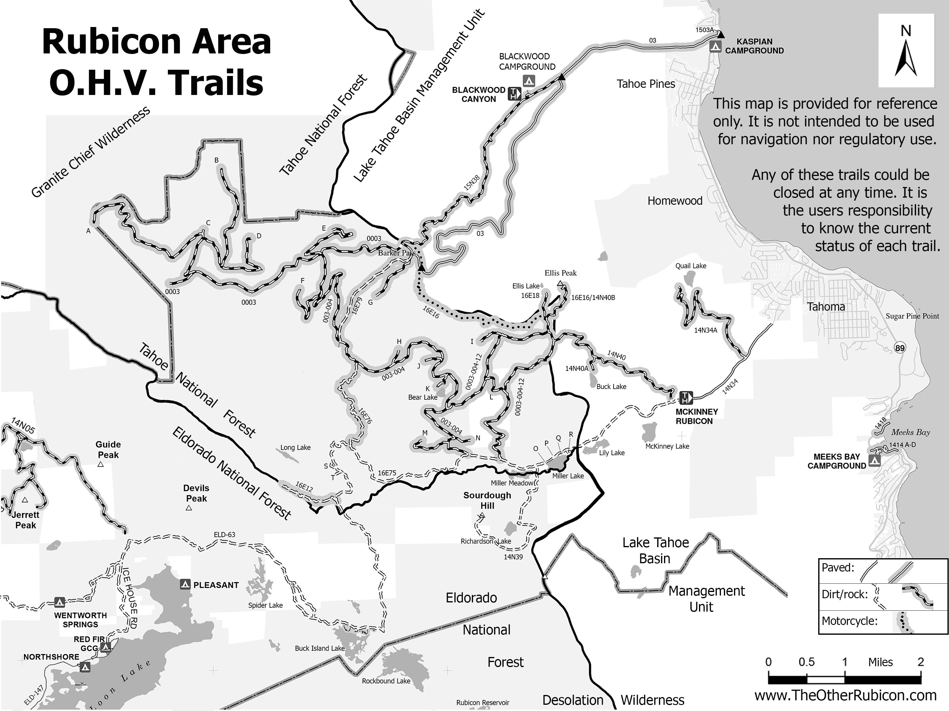
New Rubicon Area OHV Trails Map
Posted: March 18, 2015 Filed under: Access, Travel | Tags: access, education, ENF, LTBMU, rubicon trail, TNF Leave a commentSo, some time ago, I posted a new map of OHV trails in the area of the Tahoe side of the Rubicon Trail. Since then, I’ve learned a lot about using Photoshop. The old map was 72dpi, the new map was 300dpi. The old map was a cluttered mess. The new map is leaner and cleaner.
I’ve bounced different drafts off a lot of people including those within the Forest Service (FS). Some in the FS were not overwhelmingly in support. Some had concerns over the possible differences between my map and current MVUM provided by the FS.
I’ve gone further to distance this map from the official FS MVUM. The FS MVUM is a legal document used to notify the public as to what trails are open for public use. This new map is not intended for navigation nor is it to be used to determine what trails are currently open. This map displays ALL the OHV trails in the area but does not report which are open and which are closed. All but the Rubicon are seasonally closed. At least one is partially closed due to meadow issues.
It is the users responsibility to know where they are at all times and the status of the trail they are driving. Please visit the forest website and read all forest orders that may apply.
Hot off the presses:
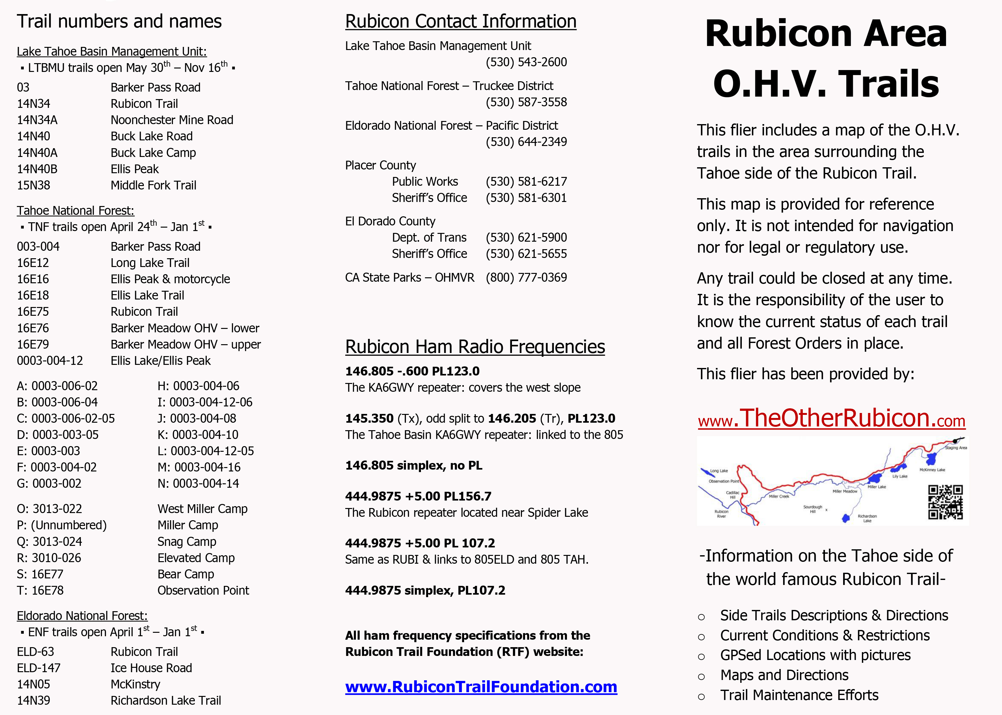
I’ve created a flier from this map to be handed out to users. Here is the front side of the flier with information on the names of trails, seasonal dates for the opening of those trails (which could be changed at any time), ham freqs, agency contact information, etc.
I’ll be handing this map out at the Reno Motorsports Show this Friday and Saturday. The maps will be there Sunday but I have to work. Stop by and pick up a few. I’m still open to comments about what could make this a better map for the users.
The 2015 Cone Zone
Posted: March 15, 2015 Filed under: Access, Travel | Tags: El Dorado County, Placer, Rubicon Leave a commentYes, the orange blooms are already happening.
Road construction has started in the Lake Tahoe Basin. This is important enough that I may start a direct link to updated information on current construction project that could affect driving to and/or from the world Famous Rubicon Trail.
The website of the week: http://www.tahoeroads.com/
This website has all kinds of information on road construction around Tahoe. The easiest page to understand has pictures. So, rather than me ramble on with too many words, here are two pictures pages that says it all. The link is for the web page of the two images below.
http://www.tahoeroads.com/docs/files/File/TahoeBasinMap2014%20with%20logo.pdf:
![]()
![]()
The Sierra Sun is also reporting:
- Paving treatment on Highway 267, airport to the summit, May-Oct, 20 minute delays
- Paving treatment on 28, between Tahoe City and 267. Aug-Oct, 10 minute delays
- Bridge replacement on the road to Alpine Meadows at 89, May-Oct
- Highway 80 at the Donner Lake Interchange, May-July
- Highway 80 Boca to Floriston, May-Oct, 20 minute delays
Please check conditions before you travel. Add time to your trip as needed. Watch out for the workers.

